Freienwil
| Freienwil | |
|---|---|
| State : |
|
| Canton : |
|
| District : | to bathe |
| BFS no. : | 4028 |
| Postal code : | 5423 |
| Coordinates : | 666 897 / 261 739 |
| Height : | 461 m above sea level M. |
| Height range : | 428–624 m above sea level M. |
| Area : | 3.99 km² |
| Residents: | 1042 (December 31, 2019) |
| Population density : | 261 inhabitants per km² |
|
Proportion of foreigners : (residents without citizenship ) |
12.9% (December 31, 2019) |
| Website: | www.freiwil.ch |
|
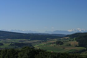
View of Freienwil |
|
| Location of the municipality | |
Freienwil ( Swiss German : ˌfrɛjəˈʋiːl ) is a municipality in the Swiss canton of Aargau . It belongs to the Baden district and is located around three kilometers north of the district capital of Baden .
geography
The village is located in a southern side valley of the Surb valley . The valley, which runs from south to north, forms a shallow depression on the edge of the Siggenberg, which is part of the Table Jura . The terrain rises towards the west to the Hörndli ( 624 m above sea level ), a foothill of the Siggenberg. The Büel ( 526 m above sea level ) forms the boundary to the valley of Ehrendingen to the east . In the south, the valley of the hazel Buck (is 578 m above sea level. M. ) completed the Limmat out, there is a narrow passage. The community area is drained by the Rickenbach, which flows into the Surb near Lengnau .
The area of the municipality is 399 hectares , of which 154 hectares are covered with forest and 39 hectares are built over. The highest point is at 624 meters on the Hörndli, the lowest at 428 meters on the northeastern municipal boundary. Neighboring communities are Lengnau in the north, Ehrendingen in the east, Ennetbaden in the south and Obersiggenthal in the west.
history
The village emerged in the 8th century in the course of the Alemannic conquest. Friginwillare was first mentioned in a document in 1230. The place name comes from the Old High German Friginwilari and means "court settlement of the free". Landowners in the High and Late Middle Ages included the monasteries Einsiedeln , Sankt Blasien and Wettingen . In fact, however, the influence of the monasteries was small, because the village was a relatively compact twing under the control of ministerials from the city of Baden . These were in the service of the Habsburgs , who exercised blood jurisdiction.
The lower jurisdiction was in the hands of the Lords of Rümlang until 1367 , after which various Baden citizens took turns who resided in the defunct Weiherhaus. In 1506 the Freienwilers were able to buy their way out for 615 guilders , an extraordinarily high sum of money at the time, after which they had the right to conduct the village court independently. Since the conquest of Aargau by the Confederates in 1415, Freienwil has been part of the Ehrendingen administrative district in the county of Baden , a common rule . In 1798 the French took Switzerland and proclaimed the Helvetic Republic . Freienwil was initially a municipality in the short-lived canton of Baden , since 1803 it has belonged to the canton of Aargau.
Due to the population increase, some of the residents became impoverished and economic development stalled. Since working from home brought in little additional income, many farmers were forced to emigrate in the 19th century. The population stagnated for more than a century. It did not begin to increase until the mid-1950s, when the village was increasingly drawn into the wake of the expanding Zurich agglomeration .
Attractions
coat of arms
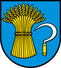
The blazon of the municipal coat of arms reads: "In blue, yellow sheaf of corn, on the left accompanied by a white sickle with a yellow handle." The coat of arms represents the agricultural tradition of the municipality. It was introduced in 1928 at the suggestion of the local men's choir.
population
The population developed as follows:
| year | 1799 | 1850 | 1900 | 1930 | 1950 | 1960 | 1970 | 1980 | 1990 | 2000 | 2010 |
| Residents | 280 | 506 | 370 | 466 | 416 | 366 | 464 | 489 | 641 | 753 | 918 |
On December 31, 2019, 1,042 people lived in Freienwil, the proportion of foreigners was 12.9%. In the 2015 census, 41.4% described themselves as Roman Catholic and 19.4% as Reformed ; 39.2% were non-denominational or of other faiths. 94.2% said German as their main language in the 2000 census , 1.7% French and 1.5% English .
Politics and law
The assembly of those entitled to vote, the municipal assembly , exercises legislative power. The executing authority is the five-member municipal council . He is elected by the people in the majority procedure, his term of office is four years. The parish council leads and represents the parish. To this end, it implements the resolutions of the municipal assembly and the tasks assigned to it by the canton. The Baden District Court is responsible for litigation in the first instance . Freienwil belongs to the Friedensrichterkreis III (Baden).
economy
According to the company structure statistics (STATENT) collected in 2015, there are around 120 jobs in Freienwil, of which 23% are in agriculture, 7% in industry and 70% in the service sector. Most of the employed people are commuters and work in the agglomerations of Baden and Zurich . Freienwil is primarily a residential community.
traffic
Freienwil is located on the little-used canton road 427 between Obersiggenthal and Lengnau , from which the canton road 426 branches off to Oberehrendingen . Most of the through traffic leads east past the village through Ober- and Unterehrendingen. The village is served by a post bus line from Baden train station to Tegerfelden . On weekends, a night bus runs from Baden via Freienwil and Klingnau to Bad Zurzach .
education
The community has a kindergarten and a schoolhouse where primary school is taught. The Realschule and the secondary school can be visited in Lengnau , the district school in Endingen . The closest grammar schools are the Baden Cantonal School and the Wettingen Cantonal School .
Others
The village and the Freienwil forest served as the main filming locations for the fourth season of the SRF crime series Der Bestatter in summer 2015 . In the series the village is called Morgenthal and is located near Aarau .
literature
- Andreas Steigmeier : Freienwil. In: Historical Lexicon of Switzerland .
- Peter Hoegger: The art monuments of the canton of Aargau . Ed .: Society for Swiss Art History . Volume VII: District of Baden II. Birkhäuser Verlag, Basel 1995, ISBN 3-909164-44-7 , p. 27-34 .
Web links
Individual evidence
- ↑ Cantonal population statistics 2019. Department of Finance and Resources, Statistics Aargau, March 30, 2020, accessed on April 2, 2019 .
- ↑ Cantonal population statistics 2019. Department of Finance and Resources, Statistics Aargau, March 30, 2020, accessed on April 2, 2019 .
- ↑ a b Beat Zehnder: The community names of the canton of Aargau . In: Historical Society of the Canton of Aargau (Ed.): Argovia . tape 100 . Verlag Sauerländer, Aarau 1991, ISBN 3-7941-3122-3 , p. 144-145 .
- ^ National map of Switzerland, sheet 1070, Swisstopo.
- ↑ Standard area statistics - municipalities according to 4 main areas. Federal Statistical Office , November 26, 2018, accessed on June 7, 2019 .
- ^ Joseph Galliker, Marcel Giger: Municipal coat of arms of the Canton of Aargau . Lehrmittelverlag des Kantons Aargau, book 2004, ISBN 3-906738-07-8 , p. 158 .
- ↑ Population development in the municipalities of the Canton of Aargau since 1850. (Excel) In: Eidg. Volkszählung 2000. Statistics Aargau, 2001, archived from the original on October 8, 2018 ; accessed on June 7, 2019 .
- ↑ Resident population by religious affiliation, 2015. (Excel) In: Population and Households, Community Tables 2015. Statistics Aargau, accessed on June 7, 2019 .
- ↑ Swiss Federal Census 2000: Economic resident population by main language as well as by districts and municipalities. (Excel) Statistics Aargau, archived from the original on August 10, 2018 ; accessed on June 7, 2019 .
- ↑ circles of justice of the peace. Canton of Aargau, accessed on June 18, 2019 .
- ↑ Statistics of the corporate structure (STATENT). (Excel, 157 kB) Statistics Aargau, 2016, accessed on June 7, 2019 .
- ↑ Katharina Herzig: In the forest of "Morgenthal" the undertaker is looking for the missing investigator. Aargauer Zeitung , January 12, 2016, accessed on January 12, 2019 .
- ↑ Freienwil is "thank you for the funeral home". Swiss radio and television , January 12, 2016, accessed on January 12, 2019 .


