
Tegerfelden
| Tegerfelden | |
|---|---|
 |
|
| State : |
|
| Canton : |
|
| District : | Zurzach |
| BFS no. : | 4320 |
| Postal code : | 5306 |
| Coordinates : | 663 749 / 268 201 |
| Height : | 364 m above sea level M. |
| Height range : | 337-534 m above sea level M. |
| Area : | 7.11 km² |
| Residents: | 1196 (December 31, 2019) |
| Population density : | 168 inhabitants per km² |
|
Proportion of foreigners : (residents without citizenship ) |
17.0% (December 31, 2019) |
| Website: | www.tegerfelden.ch |
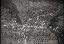
 Tegerfelden |
|
| Location of the municipality | |
  |
|
Tegerfelden ( Swiss German : ˈtægərˌfæld ) is a municipality in the Swiss canton of Aargau . It belongs to the Zurzach district and is located in the Surbtal , around three kilometers south of the border with Germany .
geography
The southern part of the village lies in the narrow valley of the Surb , the northern part in a hollow which is bordered on three sides by hills of the Table Jura . These are the Belchen ( 468 m above sea level ) in the west, the Hörndli ( 521 m above sea level ) in the north and the Imberg ( 532 m above sea level ) in the east. Extensive vineyards extend on the steep south and south-west slopes of these hills . To the south of the Surb lies the Ruckfeld, an extensive plateau, which is limited at its edges by very steep slopes up to 40 meters high.
The area of the municipality is 711 hectares , of which 268 hectares are forested and 73 hectares are built over. The highest point is at 532 meters on the Imberg, the lowest at 337 meters on the Surb. Neighboring communities are Bad Zurzach in the north, Rekingen in the northeast, Baldingen in the east, Endingen in the south and Döttingen in the west.
history
The area around Tegerfelden was already settled during the Neolithic Age between 3,500 and 5,000 years ago, as various tool finds prove. Other finds come from the Romans , the Alemanni and the Franks . Tegerfelt was first mentioned in a document in 851. The place name comes from the Old High German (ze demo) tegarin field and means "near the large field". Towards the end of the 11th century, the barons of Tegerfelden had a castle built on a rocky promontory of the Ruckfeld. From the Castle Tegerfelden a few remains of walls have been preserved.
In 1150 a Luitoldus de Tegeruelt appears in a document from the St. Blasien monastery . Well-known representatives of the Barons of Tegerfelden were Ulrich von Tegerfelden , abbot of the St. Gallen Monastery from 1167 to 1199 and at the same time Bishop of Chur between 1171 and 1179 and his nephew Konrad II of Tegerfelden , who was Bishop of Constance from 1209 to 1233 . Konrad's brother Waltherus III. died in 1254 without male descendants. His daughter Ita brought the inheritance to Ulrich von Klingen , the founder of the small town of Klingnau, through marriage . In 1276 the former property of the Tegerfeld family was transferred to the St. Blasien monastery. The Habsburgs also owned some goods and also exercised blood jurisdiction .
The Swiss conquered Aargau in 1415 and Tegerfelden now belonged to the Siggenamt in the county of Baden , a common rule . In 1529 a large part of the population converted to the Reformation . In contrast to numerous neighboring villages, the new denomination was able to assert itself here even after the Second Kappel War of 1531. Until 1661, Catholics and Reformed people shared the chapel. Then the Catholics consecrated their own church in Unterendingen , while the Reformed church expanded the chapel into a church by 1664 .
In March 1798 the French took Switzerland and proclaimed the Helvetic Republic . Tegerfelden was initially a municipality in the short-lived canton of Baden , since 1803 it has belonged to the canton of Aargau. After the opening of the Turgi – Waldshut railway lines in 1859 and Dielsdorf – Niederweningen in 1891, the Surbtal communities submitted a concession for the construction of a connecting line between Niederweningen and Döttingen . But the First World War prevented the construction of the Surb Valley Railway and the project was finally written off in 1937.
Around 1880 around 47 hectares were planted with vines . In the early 20th century, the once dominant fell viticulture into a deep crisis, caused by cheap wine imports by rail, the mildew and from North America entrained phylloxera . The acreage continued to decrease and reached its lowest point in the 1960s. Since 1970, however, an upward trend has been discernible again, the area under cultivation has been growing since then and has almost reached the old level again.
Attractions

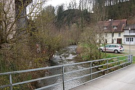
The Surb in Tegerfelden

View of the vineyards

Former court house


coat of arms
The blazon of the municipal coat of arms reads: "In blue with a red and white border, a white eagle." The community seals of 1811 and 1872 showed an illustration that was based on a misinterpretation of the place name. The outstretched arm protruding from the right edge of the shield with a sword in hand should represent the term "sword field". Around 1930 the community took over the coat of arms of the Free von Tegerfelden . The red and white border, however, had three rows, which made the eagle appear extremely small. Since 1953 the shelf has only been in a single row.
population
The population developed as follows:
| year | 1799 | 1850 | 1900 | 1930 | 1950 | 1960 | 1970 | 1980 | 1990 | 2000 | 2010 |
| Residents | 702 | 757 | 577 | 579 | 579 | 588 | 620 | 658 | 821 | 965 | 1062 |
On December 31, 2019, 1196 people lived in Tegerfelden, the proportion of foreigners was 17%. In the 2015 census, 40.7% described themselves as Roman Catholic and 29.3% as Reformed ; 30.0% were non-denominational or belonged to other faiths. In the 2000 census, 96.3% said their main language was German and 1.7% Albanian .
Politics and law
The assembly of those entitled to vote, the municipal assembly , exercises legislative power. The executing authority is the five-member municipal council . He is elected by the people in the majority procedure, his term of office is four years. The parish council leads and represents the parish. To this end, it implements the resolutions of the municipal assembly and the tasks assigned to it by the canton. The Zurzach District Court is the first instance responsible for legal disputes . Tegerfelden belongs to the XVII (Zurzach) judges' circle.
economy
According to the corporate structure statistics (STATENT) collected in 2015, there are around 450 jobs in Tegerfelden, 17% of them in agriculture, 48% in industry and 35% in the service sector. The most important branches of industry are wood processing, the manufacture of thermal coatings, and machine and apparatus engineering. Most of the employed are commuters and work mainly in Bad Zurzach or Döttingen and other communities in the region.
Viticulture , which dates back to at least the 13th century, is of supraregional importance in Tegerfelden . The cultivation area is 35.7 hectares, making it the second largest of all Aargau communities, only surpassed by Schinznach . Two dozen varieties are grown , with Blauburgunder , Pinot gris and Sauvignon Blanc being the most common. Tegerfelden is also the location of the cantonal viticulture museum.
traffic
Tegerfelden is on Hauptstrasse 17 , which leads from Döttingen through the Surbtal and Wehntal to Zurich . Its winding course through the village center has been replaced by a bypass road. Here it crosses the canton road 295 from Würenlingen over the Acheberg to Bad Zurzach . Several postal routes meet in Tegerfelden: from Brugg station to station Bad Zurzach , of Döttingen to Niederweningen and Tegerfelden to Baden train station . On weekends, a night bus runs from Baden via the Surbtal and Klingnau to Bad Zurzach.
education
The community has a kindergarten and a school house where primary school is taught. The district school can be visited in Endingen , the Realschule and the secondary school in Lengnau . The closest grammar schools are the Baden Cantonal School and the Wettingen Cantonal School .
regional customs
The Berchslete takes place on January 2nd ( Berchtold's Day). Today the bachelors dance in a polonaise through the village to the sounds of the music companies; At the end there is a joint cervelat roast around the fire. In even years, Wysonntig (wine Sunday) is a winegrower's festival.
literature
The history of Tegerfelden was summarized in a detailed village chronicle. Volume I was published in 1989. Volume II gives an insight into life and people in the past and present rural society around Tegerfelden. Both volumes can be obtained from the municipal council office.
Personalities
- Konrad II von Tegerfelden , Bishop of Constance from 1209 to 1233
- Martin Müller (1878–1957), industrialist
- Otto Sutermeister (1832–1901), educator and folk fairy tale collector
Web links
- Official website of the municipality of Tegerfelden
- Bruno Meier : Tegerfelden. In: Historical Lexicon of Switzerland .
Individual evidence
- ↑ Cantonal population statistics 2019. Department of Finance and Resources, Statistics Aargau, March 30, 2020, accessed on April 2, 2019 .
- ↑ Cantonal population statistics 2019. Department of Finance and Resources, Statistics Aargau, March 30, 2020, accessed on April 2, 2019 .
- ↑ a b Beat Zehnder: The community names of the canton of Aargau . In: Historical Society of the Canton of Aargau (Ed.): Argovia . tape 100 . Verlag Sauerländer, Aarau 1991, ISBN 3-7941-3122-3 , p. 419-424 .
- ↑ Standard area statistics - municipalities according to 4 main areas. Federal Statistical Office , November 26, 2018, accessed on June 14, 2019 .
- ^ Trudpert Neugart: Codex Diplomaticus Alemanniae Et Burgundiae Trans-luranae Intra Fines Dioecesis Constantientis, Volume 2, pp. 81f.
- ^ Joseph Galliker, Marcel Giger: Municipal coat of arms of the Canton of Aargau . Lehrmittelverlag des Kantons Aargau, book 2004, ISBN 3-906738-07-8 , p. 289 .
- ↑ Population development in the municipalities of the Canton of Aargau since 1850. (Excel) In: Eidg. Volkszählung 2000. Statistics Aargau, 2001, archived from the original on October 8, 2018 ; accessed on June 14, 2019 .
- ↑ Resident population by religious affiliation, 2015. (Excel) In: Population and Households, Community Tables 2015. Statistics Aargau, accessed on June 14, 2019 .
- ↑ Swiss Federal Census 2000: Economic resident population by main language as well as by districts and municipalities. (Excel) Statistics Aargau, archived from the original on August 12, 2018 ; accessed on June 14, 2019 .
- ↑ circles of justice of the peace. Canton of Aargau, accessed on June 14, 2019 .
- ↑ Statistics of the corporate structure (STATENT). (Excel, 157 kB) Statistics Aargau, 2016, accessed on June 13, 2019 .
- ↑ Grape harvest control 2018 Canton Aargau. (PDF, 2.4 MB) Agricultural Center Liebegg, 2019, accessed on June 14, 2019 .
- ↑ Cantonal Viticulture Museum
- ↑ Peter Keller: "The racing pillars run after me like little dogs". aargauerzeitung.ch, September 19, 2012, accessed on July 4, 2016 .
Bad Zurzach | Baldingen | Böbikon | Böttstein | Döttingen | Endingen | Fisibach | Full-Reuenthal | Kaiserstuhl | Klingnau | Koblenz | Leibstadt | Lengnau | Leuggern | Mellikon | Rekingen | Rietheim | Rümikon | Schneisingen | Siglistorf | Tegerfelden | Wislikofen
Former municipality: Mellstorf | Oberleibstadt | Unterendingen | Unterleibstadt
Canton of Aargau | Districts of the Canton of Aargau | Municipalities in the Canton of Aargau