
Wislikofen
| Wislikofen | |
|---|---|
 |
|
| State : |
|
| Canton : |
|
| District : | Zurzach |
| BFS no. : | 4322 |
| Postal code : | 5463 |
| Coordinates : | 669 427 / 267855 |
| Height : | 394 m above sea level M. |
| Height range : | 367-585 m above sea level M. |
| Area : | 3.75 km² |
| Residents: | 354 (December 31, 2019) |
| Population density : | 94 inhabitants per km² |
|
Proportion of foreigners : (residents without citizenship ) |
11.3% (December 31, 2019) |
| Website: | www.wislikofen.ch |
 Wislikofen |
|
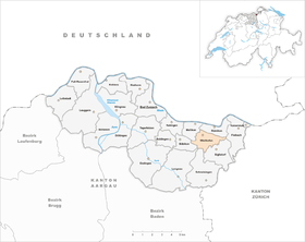
| Location of the municipality | |
  |
|
Wislikofen ( Swiss German : Wislike, ˈʋislikχə ) is a municipality in the Swiss canton of Aargau . It belongs to the Zurzach district and is about two kilometers south of the border with Germany .
geography
The community consists of the villages Wislikofen ( 394 m above sea level ) in the west and Mellstorf ( 414 m above sea level ) in the east, which are about one kilometer apart in the valley of the Tägerbach. The Tägerbach flows first from southeast to northwest, then northwards through the deeply cut Chessel Gorge, and finally flows into the Rhine east of Mellikon . The narrow valley is bounded by two elongated hills of the Tafeljura , the Gweslig ( 505 m above sea level ) in the north and the Flue ( 585 m above sea level ) in the south. Both are extremely steep in the lower area and merge into plateaus. In the far southwest, Wislikofen has a portion of the southern slope of the Flue, which drops steeply into the Chrüzlibach valley.
The area of the municipality is 375 hectares , of which 136 hectares are forested and 39 hectares are built over. The highest point is at 585 meters on the Flue plateau, the lowest at 360 meters on the Tägerbach. Neighboring communities are Rümikon in the north, Fisibach in the northeast, Siglistorf in the east, Schneisingen in the south, Böbikon in the west and Mellikon in the northwest.
history
It was first mentioned in a document in 1107. At that time, Adelbero de Wiscilinchoven appeared as a witness at a property business owned by the Allerheiligen monastery in Schaffhausen . The place name comes from the Old High German Wizzilinghofun and means "at the farms of the Wizzilo clan". On December 27, 1113, the nobles gave of Waldhausen the monastery of St. Blaise large landholdings in the region. The Benedictine monastery then set up a provost's office to administer the newly acquired, but rather distant property. The Wislikofen provost developed into a cultural and economic center and shaped the village community for centuries.
Patrons of the monastery and owners of blood jurisdiction over the village were initially the Counts of Kyburg , after their extinction from 1273 the Habsburgs . The Swiss conquered Aargau in 1415 and Wislikofen now belonged to the Ehrendingen office of the County of Baden , a common rule . In March 1798 the French took Switzerland and proclaimed the Helvetic Republic . Wislikofen was initially a municipality in the short-lived canton of Baden , since 1803 it has belonged to the canton of Aargau. The small neighboring community of Mellstorf was incorporated on January 1, 1899. The community remained agricultural until well into the 20th century.
In 2000 Wislikofen joined the administrative cooperation “Verwaltung2000”, which handles the administrative tasks of seven communities in the neighborhood. The municipality has been involved in the “Rheintal +” project since 2014, which envisages the merger of nine municipalities to form the municipality of Zurzach . After the community assembly approved the merger on May 23, 2019 with 85 to 12 votes, the decision was confirmed on September 8, 2019 in a referendum with 109 to 41 votes. This means that the merger will take place on January 1, 2022 (but without Mellikon , which narrowly refused).
Attractions


The villagescape of Wislikofen is shaped by the Wislikofen Propstei, founded in 1113 . After it was secularized in 1804 , it belonged jointly to the parish and the canton. Since the building was hardly used anymore, it fell into disrepair over time. In 1962, the Grand Council even decided to demolish it, but concerns about monument protection postponed the implementation of this measure. The spirit of optimism at the Second Vatican Council led to the opening of numerous Catholic educational institutions, and the Wislikofen priory was also to be used in this way. In 1973 the Roman Catholic Church in Aargau acquired the building. It has served as a seminar and education center since 1976, and is also used as a hotel and restaurant. The parish church of Wislikofen, which has existed since 1137, is attached to it.
coat of arms
The blazon of the municipal coat of arms reads: "White lion soaring in blue on a green hill." The municipal coat of arms goes back to that of the provost office of the St. Blasien monastery, which can be traced back to 1562.
population
The population developed as follows:
| year | 1850 | 1900 | 1930 | 1950 | 1960 | 1970 | 1980 | 1990 | 2000 | 2010 |
| Residents | 291 | 240 | 246 | 286 | 238 | 246 | 284 | 374 | 344 | 329 |
On December 31, 2019, 354 people lived in Wislikofen, the proportion of foreigners was 11.3%. In the 2015 census, 46.6% described themselves as Roman Catholic and 21.3% as Reformed ; 32.1% were non-denominational or of other faiths. In the 2000 census, 98.5% stated German as their main language.
Politics and law
The assembly of those entitled to vote, the municipal assembly , exercises legislative power. The executing authority is the five-member municipal council . He is elected by the people in the majority procedure, his term of office is four years. The parish council leads and represents the parish. To this end, it implements the resolutions of the municipal assembly and the tasks assigned to it by the canton. The Zurzach District Court is the first instance responsible for legal disputes . Wislikofen belongs to the XVII peace judges' circle (Zurzach).
economy
According to the company structure statistics (STATENT) collected in 2015, Wislikofen has around 150 jobs, including 26% in agriculture, 35% in industry and 39% in the service sector. Many employed people are commuters and work in Bad Zurzach and the surrounding area or in the Baden region .
traffic
Wislikofen is a bit away from the through traffic on Kantonsstrasse 431, but can be easily reached via Hauptstrasse 7 from Basel to Winterthur, a few kilometers away . The connection to the public transport network is made by a post bus line from Kaiserstuhl via Niederweningen to Baden train station .
education
In Wislikofen there is a kindergarten and a school house in which the primary school (1st and 2nd grade) is taught. The 3rd to 6th primary school classes can be attended in Rekingen , all upper levels ( Realschule , Secondary School and District School ) in Bad Zurzach . The closest grammar schools are the Baden Cantonal School and the Wettingen Cantonal School . On the southern outskirts of Wislikofen is the "Haus Goldenbühl", a home for young people with mental and physical disabilities.
Web links
- Official website of the municipality of Wislikofen
- Administration2000 (administrative cooperation)
- Christoph Herzig: Wislikofen. In: Historical Lexicon of Switzerland .
- Christoph Herzig: Mellstorf. In: Historical Lexicon of Switzerland .
Individual evidence
- ↑ Cantonal population statistics 2019. Department of Finance and Resources, Statistics Aargau, March 30, 2020, accessed on April 2, 2019 .
- ↑ Cantonal population statistics 2019. Department of Finance and Resources, Statistics Aargau, March 30, 2020, accessed on April 2, 2019 .
- ↑ a b Beat Zehnder: The community names of the canton of Aargau . In: Historical Society of the Canton of Aargau (Ed.): Argovia . tape 100 . Verlag Sauerländer, Aarau 1991, ISBN 3-7941-3122-3 , p. 365-367 .
- ^ National map of Switzerland, sheet 1050, Swisstopo.
- ↑ Standard area statistics - municipalities according to 4 main areas. Federal Statistical Office , November 26, 2018, accessed on June 17, 2019 .
- ↑ About us. Verwaltung2000, accessed June 17, 2019 .
- ^ Philipp Zimmermann, Andreas Fretz, David Rutschmann: Grossfusion im Zurzibiet: 9 municipalities say yes to «Zurzach» - Fisibach refuses to join. Aargauer Zeitung , May 24, 2019, accessed on June 17, 2019 .
- ↑ Pirmin Kramer, Daniel Weissenbrunnen: Zurzibieter large merger is perfect! Eight municipalities say yes, only Mellikon refuses. Aargauer Zeitung , September 8, 2019, accessed on September 10, 2019 .
- ^ Propstei Wislikofen
- ^ Joseph Galliker, Marcel Giger: Municipal coat of arms of the Canton of Aargau . Lehrmittelverlag des Kantons Aargau, book 2004, ISBN 3-906738-07-8 , p. 317 .
- ↑ Population development in the municipalities of the Canton of Aargau since 1850. (Excel) In: Eidg. Volkszählung 2000. Statistics Aargau, 2001, archived from the original on October 8, 2018 ; accessed on June 17, 2019 .
- ↑ Resident population by religious affiliation, 2015. (Excel) In: Population and Households, Community Tables 2015. Statistics Aargau, accessed on June 17, 2019 .
- ↑ Swiss Federal Census 2000: Economic resident population by main language as well as by districts and municipalities. (Excel) Statistics Aargau, archived from the original on August 12, 2018 ; accessed on June 17, 2019 .
- ↑ circles of justice of the peace. Canton of Aargau, accessed on June 17, 2019 .
- ↑ Statistics of the corporate structure (STATENT). (Excel, 157 kB) Statistics Aargau, 2016, accessed on June 17, 2019 .
Bad Zurzach | Baldingen | Böbikon | Böttstein | Döttingen | Endingen | Fisibach | Full-Reuenthal | Kaiserstuhl | Klingnau | Koblenz | Leibstadt | Lengnau | Leuggern | Mellikon | Rekingen | Rietheim | Rümikon | Schneisingen | Siglistorf | Tegerfelden | Wislikofen
Former municipality: Mellstorf | Oberleibstadt | Unterendingen | Unterleibstadt
Canton of Aargau | Districts of the Canton of Aargau | Municipalities in the Canton of Aargau