
Endingen AG
| AG is the abbreviation for the canton of Aargau in Switzerland and is used to avoid confusion with other entries of the name Endingen . |
| Endingen | |
|---|---|
 |
|
| State : |
|
| Canton : |
|
| District : | Zurzach |
| BFS no. : | 4305 |
| Postal code : | 5304 |
| UN / LOCODE : | CH EDG |
| Coordinates : | 664 129 / 265 612 |
| Height : | 384 m above sea level M. |
| Height range : | 365-594 m above sea level M. |
| Area : | 11.91 km² |
| Residents: | 2563 (December 31, 2019) |
| Population density : | 215 inhabitants per km² |
|
Proportion of foreigners : (residents without citizenship ) |
18.3% (December 31, 2019) |
| Website: | www.endingen.ch |
 Endingen village center |
|
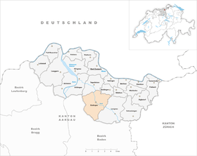
| Location of the municipality | |
  |
|
Endingen ( Swiss German : ˈændigə ) is a municipality in the Swiss canton of Aargau . It belongs to the Zurzach district and is located in the Surbtal , around four kilometers from the border with Germany . In the 18th and 19th centuries, Endingen and the neighboring village of Lengnau were the only places in Switzerland where Jews were allowed to settle. Until 1945 the municipality was called Oberendingen , in 2014 the merger with Unterendingen took place .
geography
The cluster village is located at the confluence of the Littenbach in the Surb . The Surbtal, which initially runs in a westerly direction, turns to the north in the village center. The valley narrows and is bordered by the Ruckfeld in the west and the Hörndlihau ( 543 m above sea level ) in the east. The Ruckfeld is a plateau, which is limited at its edges by steeply sloping flanks up to 40 meters high. The Hörndlihau is part of the Table Jura , the initially steep flank gradually turns into a plateau. The area south of the village is geologically part of the transition zone to the Central Plateau . The slopes of the long Siggenberg , the natural border to the Limmat Valley , are significantly flatter and more even. About one kilometer southeast of the village center is the small hamlet Loohof ( 430 m above sea level ). About one kilometer north of the village, at the confluence of the Schlierenbach in the Surb, lies the village of Unterendingen ( 386 m above sea level ).
The area of the municipality is 1191 hectares , of which 520 hectares are forested and 116 hectares are built over. The highest point is at 593 meters on the Siggenberg, the lowest at 375 meters on the Surb. Neighboring communities are Tegerfelden in the north, Baldingen in the northeast, Lengnau in the east, Obersiggenthal in the south and Würenlingen in the west.
history
Individual finds from the Neolithic and Bronze Age bear witness to an early settlement. The Alemanni settled in around the 6th century. Entingas was first mentioned in a document in 798, when Count Odalricus from Thurgau donated some land to the St. Gallen monastery. The place name comes from the Old High German Antingun and means "among the people of Anto". In the High Middle Ages the village was under the influence of the Barons of Regensberg and the Diocese of Constance . Their ministerials were the barons of Tegerfelden and, since at least 1239, the knights of Endingen. From 1305 at the latest, blood jurisdiction lay with the Habsburgs , while the monastery of St. Blasien exercised the lower jurisdiction .
In 1415 the Swiss conquered Aargau, Endingen now belonged to the Siggenamt of the County of Baden , a common rule . From 1678 on, Jews settled in Endingen for the first time , earning their living primarily at the internationally important Zurzach trade fair and at the market in Baden . The Jews were directly subordinate to the governor in Baden; they were not allowed to practice agriculture or any craft. From 1696 they had to buy an expensive protection and umbrella letter every 16 years. From 1776 the right of residence of all Jews in Switzerland was restricted to Endingen and Lengnau . Since they were only allowed to stay in the two villages at night, their radius of action was severely restricted.

In March 1798 the French took Switzerland and proclaimed the Helvetic Republic , Endingen initially belonged to the short-lived canton of Baden . The new state was soon hated by large sections of the population. This hatred erupted on September 21, 1802 in the so-called "Plum War" against the Jews, who were considered supporters of the new, more liberal order. A horde of more than 800 residents from the neighboring villages attacked Endingen and Lengnau and enriched themselves with the belongings of the defenseless Jews, while the Christian residents were largely unmolested.

Endingen has belonged to the canton of Aargau since 1803; at that time the Jews made up around 45 percent of the total population. In 1850 the community had 1941 inhabitants, slightly more than half of them were Jews. The Jewish corporation was self-governing and ran its own school. Only with the revised Federal Constitution of 1874 did the Jews receive full civil equality. As a result, almost all of them moved to the big cities (especially Zurich ), where they found better earning opportunities. As a result, the population of the village fell by almost half. Today there are only a few Jewish residents left in Endingen.
After the opening of the Turgi – Koblenz – Waldshut railway in 1859 and the Dielsdorf – Niederweningen railway in 1891, the Surbtal communities submitted a concession to build a connection between Niederweningen and Döttingen . But the First World War prevented the construction of the Surb Valley Railway and the project was finally abandoned in 1937. Small industries have settled in Endingen since the 1960s. The population, which had stagnated until the beginning of the 1970s, has been rising again since then and has exceeded the level of 1850 at the beginning of the 21st century. On June 15, 2012, the community meetings of Endingen and Unterendingen approved the merger of the two communities. In the referendum on September 23, 2012, the resolution in Endingen was confirmed with 612 to 55 votes, whereupon the merger took place on January 1, 2014.
Attractions


For historical reasons, Endingen has neither a Catholic nor a Reformed church. Catholics have been attending church services in Unterendingen and the Reformed in Tegerfelden since 1661 . The only place of worship is the Endingen synagogue . The Jewish cemetery in Endingen is located on the border with Lengnau .
Numerous houses in the village center have an architectural peculiarity. Contrary to the regulations, the Jews often lived under the same roof with Christians and circumvented the prohibition by not using the same house entrance. For this reason, these houses were given two entrances directly next to each other. The various Jewish buildings in the village are connected to one another by the Endingen-Lengnau Jewish Cultural Trail . The association of the same name emerged from the “double door” mediation project, which began implementing a visitor center in October 2018 with the purchase of a double door house in Lengnau.
coat of arms
The blazon of the municipal coat of arms reads: "Split of red and yellow, covered with split lily of white and blue." From 1926, the municipality carried the coat of arms of the Lords of Endingen, the oldest known representation of which comes from a register of coats of arms from 1621. In 1934, however, the remains of the castle of this ministerial family were found in Unterendingen . Unterendingen claimed the coat of arms for themselves and in 1953 appealed to the government council , which, however, decided in favor of Endingen.
population
The population developed as follows:
| year | 1799 | 1850 | 1900 | 1930 | 1950 | 1960 | 1970 | 1980 | 1990 | 2000 | 2010 |
| Residents | 1120 | 1941 | 1121 | 1036 | 1082 | 1041 | 1161 | 1503 | 1539 | 1766 | 2009 |
On December 31, 2019, 2563 people lived in Endingen, the proportion of foreigners was 18.3%. In the 2015 census, 40.7% described themselves as Roman Catholic and 24.2% as Reformed ; 35.1% were non-denominational or of other faiths. 92.9% said German as their main language in the 2000 census , 2.4% Albanian , 1.2% French , 1.0% Italian and 0.8% each of English and Serbo-Croatian .
Politics and law
The assembly of those entitled to vote, the municipal assembly , exercises legislative power. The executing authority is the five-member municipal council . He is elected by the people in the majority procedure, his term of office is four years. The parish council leads and represents the parish. To this end, it implements the resolutions of the municipal assembly and the tasks assigned to it by the canton. The Zurzach District Court is the first instance responsible for legal disputes . Endingen belongs to the XVII peace judges' circle (Zurzach).
economy
According to the company structure statistics (STATENT) collected in 2015, there are around 760 jobs in Endingen, 18% of them in agriculture, 30% in industry and 52% in the service sector. Around two thirds of the workforce are commuters and work in the surrounding communities and in the Baden region . Viticulture is carried out on an area of 4.5 hectares on the south-western slope of Hörndlihau , with the Blauburgunder , Maréchal Foch and Riesling varieties being the most common.
traffic
Endingen is on the main road 17 , which leads from Döttingen through the Surbtal and the Wehntal to Zurich . Four postal routes open up the village: from Endingen or Tegerfelden for bathing , from Brugg station to station Bad Zurzach and of Döttingen to Niederweningen . There is a connection to the Zurich S-Bahn at Niederweningen station . On weekends, a night bus runs from Baden via the Surbtal and Klingnau to Bad Zurzach.
education
The community has kindergartens and school houses in which the primary school and the district school are taught. The Realschule and the Secondary School can be attended in Lengnau . The closest grammar schools are the Baden Cantonal School and the Wettingen Cantonal School .
Sports
The handball club TV Endingen is known throughout Switzerland . The men's team plays in the National League A and has played its home games in the GoEasy Arena in Siggenthal Station since 2016 .
Personalities
- Bruno Bloch (1878-1933), dermatologist
- Markus G. Dreyfus (1812–1877), teacher and fighter for the equality of Jews
- Markus Guggenheim (1885–1970), biochemist
- Joël Keller (* 1995), football player
- Johannes Emil Keller (1879–1953), member of the revival movement and founder of the Keller community
- Monika Schärer (* 1968), moderator
- Victor Hermann Umbricht (1915–1988), lawyer and diplomat
literature
- Edith Hunziker, Ralph Weingarten: The synagogues of Lengnau and Endingen and the Jewish cemetery . In: Swiss art guides . tape 771/772 . Society for Swiss Art History , Bern 2005, ISBN 3-85782-771-8 .
- Anna Rapp: Jewish cultural assets in and from Endingen and Lengnau . Regional culture publishing house, Ubstadt-Weiher 2008, ISBN 978-3-89735-493-7 .
- Andreas Steigmeier : Endingen. In: Historical Lexicon of Switzerland .
- Peter Stein: Living and lost Jewish customs, customs yesterday and today, customs here and there, with special consideration of the Swiss Jewish villages of Endingen and Lengnau . Regional culture publishing house, Ubstadt-Weiher 2008, ISBN 978-3-89735-551-4 .
Web links
Individual evidence
- ↑ Cantonal population statistics 2019. Department of Finance and Resources, Statistics Aargau, March 30, 2020, accessed on April 2, 2019 .
- ↑ Cantonal population statistics 2019. Department of Finance and Resources, Statistics Aargau, March 30, 2020, accessed on April 2, 2019 .
- ↑ a b Beat Zehnder: The community names of the canton of Aargau . In: Historical Society of the Canton of Aargau (Ed.): Argovia . tape 100 . Verlag Sauerländer, Aarau 1991, ISBN 3-7941-3122-3 , p. 142-143 .
- ^ National map of Switzerland, sheets 1050 and 1070, Swisstopo.
- ↑ Standard area statistics - municipalities according to 4 main areas. Federal Statistical Office , November 26, 2018, accessed on June 15, 2019 .
- ↑ Harald Derschka : Die Ministeriale des Hochstiftes Konstanz (= Konstanz working group for medieval history: lectures and research. Special volume 45). Thorbecke, Stuttgart 1999, ISBN 3-7995-6755-0 , pp. 231-234.
- ^ Equality of the Swiss Jews: "A success story". SRF , January 16, 2016, accessed November 5, 2019 .
- ↑ Unterendingen and Endingen decide to merge. Aargauer Zeitung , September 23, 2012, accessed on June 15, 2019 .
- ↑ placement project Endingen Lengnau DOUBLE DOOR
- ↑ The new center will tell the story of the Aargau Jews. Swiss radio and television , October 30, 2018, accessed October 30, 2018 .
- ^ Joseph Galliker, Marcel Giger: Municipal coat of arms of the Canton of Aargau . Lehrmittelverlag des Kantons Aargau, book 2004, ISBN 3-906738-07-8 , p. 150 .
- ↑ Population development in the municipalities of the Canton of Aargau since 1850. (Excel) In: Eidg. Volkszählung 2000. Statistics Aargau, 2001, archived from the original on October 8, 2018 ; accessed on June 15, 2019 .
- ↑ Resident population by religious affiliation, 2015. (Excel) In: Population and Households, Community Tables 2015. Statistics Aargau, accessed on June 15, 2019 .
- ↑ Swiss Federal Census 2000: Economic resident population by main language as well as by districts and municipalities. (Excel) Statistics Aargau, archived from the original on August 12, 2018 ; accessed on June 15, 2019 .
- ↑ circles of justice of the peace. Canton of Aargau, accessed on June 15, 2019 .
- ↑ Statistics of the corporate structure (STATENT). (Excel, 157 kB) Statistics Aargau, 2016, accessed on June 15, 2019 .
- ↑ Grape harvest control 2018 Canton Aargau. (PDF, 2.4 MB) Agricultural Center Liebegg, 2019, accessed on June 15, 2019 .
- ^ TV Endingen
Bad Zurzach | Baldingen | Böbikon | Böttstein | Döttingen | Endingen | Fisibach | Full-Reuenthal | Kaiserstuhl | Klingnau | Koblenz | Leibstadt | Lengnau | Leuggern | Mellikon | Rekingen | Rietheim | Rümikon | Schneisingen | Siglistorf | Tegerfelden | Wislikofen
Former municipality: Mellstorf | Oberleibstadt | Unterendingen | Unterleibstadt
Canton of Aargau | Districts of the Canton of Aargau | Municipalities in the Canton of Aargau