
Bad Zurzach
| Bad Zurzach | |
|---|---|
 |
|
| State : |
|
| Canton : |
|
| District : | Zurzach |
| BFS no. : | 4323 |
| Postal code : | 5330 |
| Coordinates : | 664 291 / 271 129 |
| Height : | 340 m above sea level M. |
| Height range : | 317-521 m above sea level M. |
| Area : | 6.52 km² |
| Residents: | 4368 (December 31, 2019) |
| Population density : | 670 inhabitants per km² |
|
Proportion of foreigners : (residents without citizenship ) |
38.7% (December 31, 2019) |
| Website: | www.badzurzach.ch |
 Thermal bath with tower hotel |
|
| Location of the municipality | |
  |
|
Bad Zurzach (until December 1, 2006 officially: Zurzach , Swiss German : Zùùrzi [ˈt͡sʊːrt͡si] , Latin Tenedone ) is a municipality in the Swiss canton of Aargau and the capital of the Zurzach district in the northeast of the canton. The place forms a regional sub-center, but has not developed into a city, even if it had a town hall, market rights (1433) and a hospital early on. For this reason Bad Zurzach is traditionally referred to as " Flecken ".
The village is located on the Upper Rhine on the border with Germany and has recently become a popular tourist destination , mainly because of the Zurzach thermal baths . Since the Middle Ages , the grave of Saint Verena has been the destination of a national pilgrimage .
geography
The settlement area of Bad Zurzach extends in the almost 500 meter wide river plain to the left of the Rhine from southeast to northwest over a length of more than two kilometers. Near the town center, the river flowing in a north-westerly direction bends in a wide curve to the north. At this point the plain expands to a width of one and a half kilometers.
The historic center of the place is at the exit of a small valley that separates the hills of the Table Jura . West-southwest of the center rises the Acheberg ( 535 m above sea level ) and south-south-east the Hörndli ( 521 m above sea level ). Both hills have steep flanks and merge into spacious high plateaus. In the directed against the location of the rock head Achebergs leads Chatzesteig , at the northernmost projection of Hörndli is the Chänzeli . The road leads between the two mountains over the Zurzacherberg pass crossing ( 476 m above sea level ). The southern municipal boundary runs over the top of the pass. About two kilometers north of the town center is the hamlet of Barz ( 321 m above sea level ) on the banks of the Rhine , a little more than one kilometer west of the hamlet of Acheberg ( 513 m above sea level ) in a forest clearing.
The area of the municipality is 652 hectares , of which 276 hectares are wooded and 194 hectares are built over. The highest point is at 521 meters on the Acheberg plateau, the lowest at 318 meters on the Rhine.
The neighboring communities are the German Küssaberg in the north, Rekingen in the east, Tegerfelden in the south, Döttingen in the south-west, Klingnau in the west and Rietheim in the north-west.
Place name
According to Aegidius Tschudi , the ancient place name Tenedo or Tenedone was later replaced by the name Certiacum . Onomatology leads this name back to the Gallo-Roman gentile name * Ortiacum , from which Cercach later developed. Late Latin (praedium) Ortiacum means "estate belonging to Ortius". The name development went through the forms Urziacha and Zurzacho zu Zurzach . The short slang form Zuorza has been passed down since the 12th century .
history
Archaeological finds indicate that the area on the Upper Rhine was already populated during the Neolithic around 5000 years ago and also in the Bronze Age (1200 BC). Around 400 BC There was a Celtic settlement in the area of today's Zurzach , which is documented by grave finds under Mittskirchstrasse.
Antiquity

After the defeat of the Helvetii against the Roman army under Julius Caesar in the battle of Bibracte (58 BC), the region from Lake Geneva to the Rhine gradually came under Roman rule. After the Alpine campaign in 15 BC The Romans occupied the Central Plateau. At Zurzach / Rheinheim, the XIX. Legion across the river and built the 15 to 9 BC Dangstetten Roman camp, which has been proven and excavated from 1967 onwards . Presumably from this base up to the Wutach a larger bridgehead was formed to the right of the Rhine against Germania, because the destruction of the nearby, Celtic oppidum of Altenburg-Rheinau also took place during this period . From 14 AD the landscape on the Upper Rhine belonged to the province of Gallia Belgica and after 90 AD to Germania superior . The name Tenedo (ne) is attested by the Tabula Peutingeriana .

Because of the crossing of the Rhine, Tenedo became an important military base near the legionary camp Vindonissa on the military road to Juliomagus near Schleitheim and across the Danube to Arae Flaviae (Rottweil). In the 1st century, the Roman military camp Zurzach is documented by finds of wooden buildings near Himmelrych , today 's Zurzach Castle . The archaeological findings show remains of four construction phases. A civil settlement ( vicus ) was established in the vicinity of the camp .
The Roman Estate in the quarter Entwiesen (1st to 3rd century) west of the present town center was probably the Alemanni storm destroyed around 260 by fire. After the fall of the Limes , the Roman imperial border was moved back to the Upper Rhine in the second half of the 3rd century , and a heavily fortified fort was built on the banks of the Rhine east of the Tenedo settlement (occupied 315), the later double fort Kirchlibuck-Sidelen (occupied 367) with an opposite bridgehead near Rheinheim on the Rhine bridge . The remains of the fort near Zurzach are still an impressive architectural monument today.
Numerous remains of the Roman Rhine bridges near Tenedo , which the Zurich antiquity researcher Ferdinand Keller observed around 1860, have been preserved. The systematic dendrochronological investigation of a large number of yoke piles lifted from the river bed around 1985 revealed that the trees that were processed were felled shortly after the middle of the fourth century. The construction time of the military bridge thus fell during the reign of Emperor Valentinian I (364–375 AD), when the imperial border on the Rhine was secured with numerous buildings.
It is unclear where the place called Forum Tiberii , the “market place of Tiberius ”, by Claudius Ptolemy in his Geographike Hyphegesis (also Prætorium, seu Tribunal Cæsaris op. , Where Tiberius held court) is to be located. The German historian Joseph Bader equated him with Zurzach and referred the name Tenedo to the city of Tiengen , which is now considered refuted. The attribution of Forum Tiberii to Kaiserstuhl is also considered unlikely.
According to a legend handed down in several saints' lives, the stay of Saint Verena in Zurzach goes back to the first half of the 4th century . The tradition is related to the martyrdom of the Theban Legion , and it says that Verena came from Thebes in Egypt to Mediolanum ( Milan ) and visited the place of execution of the Theban soldiers near Agaunum in Lower Valais. From there she traveled north through the Roman province, where she was also persecuted as a Christian. In Salodurum ( Solothurn ) she lived with a hermit on the site of today's “ Verenaschlucht ”, where she worked miracles, which is why the Roman governor had her locked up; but now she has cured him of an illness, and he released her. She is said to have come across the Aare to the Rhine, where she lived on an island near Tenedo and, in turn, caused miraculous healings. The saint, popular in the Diocese of Constance, has been the patron saint of nurses since the Middle Ages.
In 401 the Roman troops withdrew from the provinces north of the Alps. In the years that followed, a baptistery was built in the former Kirchlibuck fort and a first burial church was built on the Roman burial ground on the road from Tenedo south to Vindonissa , which later became a popular place of pilgrimage because of the veneration of St. Verena. In the medieval Verena Minster you can visit the grave of the holy woman in the crypt.
middle Ages
.jpg)
The immigration of Alamannen across the Rhine is documented by grave finds from the 6th to 8th centuries. During this time, a double Benedictine monastery was built in Zurzach to take care of the pilgrimage to the grave of Saint Verena , which was first mentioned in 830 with the name Zuriaca . Emperor Karl III. gave the monastery to his wife Richardis , abbess at the Säckingen monastery and in the Fraumünster Abbey in Zurich . Later the Zurzach convent came to the Reichenau monastery . On the site of the first memorial church of Saint Verena, the early Romanesque collegiate church was built around 1000 , which in 1347 received a Gothic tower choir above the crypt. Zurzach developed into an internationally known place of pilgrimage in the border region between the Duchy of Swabia and the Kingdom of Burgundy , whose rulers personally visited the grave of the popular saints, as reported in the book of miracles from that time. Zurzach developed into an important religious and economic center in Swabia and a European trade fair location. The monastery Reichenau had 1279 the Canons in Zurzach due to financial problems in the diocese of Constance resell.
In 1415 the Swiss conquered Aargau and Zurzach now belonged to the County of Baden , a common rule . The importance of the Zurzach trade fair increased as a result: merchants from all over the Confederation, from southern Germany and even from the Netherlands , Milan and Poland came to Zurzach to advertise their goods. The highlight was the Verena day on September 1st (for customs see also: Whore Dance ). The traders benefited from the market town's duty-free status and the favorable location near the mouth of the Aare into the Rhine . During the Reformation in 1529 - in the wake of the Zurich iconoclasm - some of the monastery's cultural assets were also burned. The canons left Zurzach and were able to save the objects that are still in the church treasury during their escape. As a result of the Reformation, Zurzach lost its importance as a place of pilgrimage. Although the attempt in the 16th century, the Zurzach city charter to get failed, the Venue had developed into a patch with an urban look, like the engraving by Merian Forum Tiberii Zurzach shows.
Modern times
In 1798, France incorporated Switzerland as a satellite state into its sphere of influence. Under French pressure, the Helvetic Republic was proclaimed in March 1798 and Zurzach initially became the district capital in the short-lived Canton of Baden . Zurzach has been the district capital since the canton of Aargau was founded in 1803. The fair lost more and more importance in the course of the 19th century, also due to the changed traffic flows through the construction of the railways ; The last leather fair took place in 1855. The Benedictine monastery of St. Verena existed until it was dissolved on May 17, 1876. The last canon was Zurzach's chronicler, Johann Huber (1812–1879) from Hägglingen .

Zurzach threatened to sink into economic insignificance. But in 1872 the textile manufacturer Jakob Zuberbühler used some empty houses and moved here from Baden . His company developed into a large company. Thanks to the opening of the Winterthur – Koblenz railway in 1876, Zurzach entered the industrial age. From 1900 Minet developed from a wicker manufacturer to a furniture manufacturer. After centuries of ferry operations, the bridge over the Rhine that still exists today was inaugurated in 1907. In 1914, an underground salt store was discovered near Zurzach , which was exploited with salt pans . The wooden derricks are still evidence of this time. The Swiss soda factory (today Solvay Switzerland ) settled here and developed over the decades into an international chemical company. A thermal spring was also discovered during the salt drilling, but it was initially concreted over again.
After the First World War , the companies that Zuberbühler had built up increasingly lost influence due to mismanagement and went bankrupt in 1929. From 1934, the Spiesshofer & Braun company (now Triumph International ) used the ruins for the production of their corsetry. From 1945 Zuberbühler's shoe factory belonged to Odermatt & Co. AG and thus also to Villa Himmelrych . The Second World War did not leave Zurzach unscathed: the state border was secured and closed; Units of Border Brigade 5 were deployed along the Rhine to secure the border and for construction work and were quartered in the village. The Zurzach barrier was built on the Rhine with concrete bunkers on the river bank and tank barricades. The remains of the barriers form a military-historical monument of national importance.
Development into a health resort


On September 5, 1955, enough capital was available to re-drill the thermal spring. The hot water brought the first spa guests to Zurzach, which over the next few years developed into one of the most important thermal spa resorts in Switzerland. From 1957, the mineral-rich water is also sold as a drink. 1964 was of Fedor Altherr designed tower hotel the thermal spring AG, which is now regarded as the town's landmark. In addition to the companies already mentioned, Kägi, a kitchen manufacturer from Winterthur, has also been producing in Zurzach since 1964. 1973 opened a rheumatism and rehabilitation clinic. In 1978 the Villa Himmelrych was renovated by Hugo Ammann and set up as a Deusser Museum with the name Schloss Zurzach . The spa district was expanded with hotels and a modern thermal bath. In 1991 a training center for physiotherapy and occupational therapy was founded.
Latest time
Industry in Zurzach had shrunk sharply by the beginning of the 21st century. Minet closed its doors, Solvay Switzerland followed a few years later with the shutdown of production at the Zurzach location. The premises of the companies became a commercial building resp. Converted to industrial park. Odermatt & Co. AG went bankrupt with its Oco shoes as early as 1973, and Kägi in the 1980s. Triumph International stopped its production in Zurzach and only uses the location as an administrative center. In contrast, the medical sector continued to expand. In 2004 the TCM Ming Dao opened, which offers traditional Chinese medicine as an outpatient branch of the RehaClinic Zurzach . On May 21, 2006, the voters decided to change the name of the municipality, which has been called Bad Zurzach since August 1, 2006, even if the official approval by the federal government did not become legally effective until December 1, 2006.
In 2014, the “Rheintal +” project was launched in the region around Bad Zurzach, which envisages a merger of nine Aargau municipalities in the Zurzibiet to form the new municipality of Zurzach . In addition to Bad Zurzach, Baldingen , Böbikon , Kaiserstuhl , Rekingen , Rietheim , Rümikon and Wislikofen are part of the project. After the Zurzach community assembly approved the merger on May 23, 2019 with 395 to 10 votes, the decision was confirmed on September 8, 2019 in a referendum with 755 to 252 votes. Due to the approval of most of the other municipalities, the merger will take place on January 1, 2022 as planned; however, the electorate in Mellikon narrowly rejected the proposal, so that this town, which lies roughly in the middle of the project perimeter, will not belong to the new large municipality.
population
The population developed as follows:
| year | 1510 | 1780 | 1850 | 1900 | 1930 | 1950 | 1960 | 1970 | 1980 | 1990 | 2000 | 2010 |
| Residents | about 500 | 1024 | 948 | 1287 | 1849 | 2401 | 2694 | 3098 | 3068 | 3594 | 3899 | 4161 |
On December 31, 2019, 4,368 people lived in Zurzach, the proportion of foreigners was 38.7%. In the 2015 census, 37.9% described themselves as Roman Catholic and 19.6% as Reformed ; 42.5% were non-denominational or of another faith. In the 2000 census, 82.9% said their main language was German , 3.3% Serbo-Croatian , 3.2% Italian , 2.7% Albanian , 2.0% Portuguese , 1.6% Turkish and 0.7% English .
Attractions
- Center: Although Zurzach never had town charter, the closed rows of houses in the center give the place a small-town character. The numerous exhibition halls are reminiscent of the large international markets that took place here until 1855.
- The Verena Minster was an important pilgrimage center in the Middle Ages and has served as a Catholic parish church since 1876.
- Upper church : late Gothic church built in 1517; Rebuilt in 1763 in the Rococo style; has served as a concert hall since 1944; Permanent exhibition with works by the painter Pieter van de Cuylen .
- Reformed Church : Baroque church built in 1716
- There is a Loreto chapel near Acheberg
- Zurzach Castle : the manorial villa "Himmelrych" built by the industrialist Jakob Zuberbühler at the end of the 19th century; Exhibition by the German painter August Deusser ; important watch collection has been closed since 2009. The slowly overgrown park can still be visited through the main gate, sign for the Roman military camp Zurzach .
- Castle ruins on the "Buck"
- District museum Höfli : in the former canon house; Exhibition on the Roman and early medieval history of the region.
- Restored Barzmühle
- Messehaus zur Waag, today Gasthof zur Waag
- Engelburg exhibition center
- Derrick museum
- Zoo on the Zurzacherberg
photos

Farm in the Flecken

Reformed church Zurzach and parish hall "Arche"

Schwertgasse
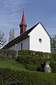
Castle chapel St. Verena and Mauritius


coat of arms
The blazon of the municipal coat of arms reads: "In white the black Gothic letter Z." The coat of arms was first depicted in this form on the seal from 1612. In 1702 a version with a white-green split shield appeared, which existed on an equal footing with the undivided white coat of arms. Finally, in 1973, the local council decided on the white version. The green and white split version has been used as the district coat of arms ever since .
Politics and law
The assembly of those entitled to vote, the municipal assembly , exercises legislative power. The executing authority is the five-member municipal council . He is elected by the people in the majority procedure, his term of office is four years. The parish council leads and represents the parish. To this end, it implements the resolutions of the municipal assembly and the tasks assigned to it by the canton. The Zurzach District Court is the first instance responsible for legal disputes . Bad Zurzach is the seat of the Friedensrichterkreis XVII, which includes the whole district.
economy
According to the corporate structure statistics (STATENT) collected in 2015, Bad Zurzach has around 3,150 jobs, of which one% is in agriculture, 13% in industry and 86% in the service sector. The main economic factor is the thermal bath . The 40 ° C warm, salty water is pumped up from a depth of 1000 meters. The modern bath complex, numerous hotels and a rehabilitation clinic make Zurzach an important tourist destination. Zurzach water is also bottled and sold as mineral water throughout Switzerland . Other important employers are the global chemicals group Solvay , the underwear manufacturer Triumph International and the transport and logistics company Indermühle.
traffic

Zurzach is on Hauptstrasse 7 between Basel and Winterthur . On the eastern edge of the village, Kantonsstrasse 295 branches off over the Zurzacherberg, which leads to Tegerfelden and Würenlingen . The Zurzach – Rheinheim bridge across the Rhine provides a connection across the border to Rheinheim . The west-east through traffic once squeezed through the historic town center. Since 1989, however, a tunnel along the Rhine has provided relief. In addition to the northern bypass, an eastern bypass is also to be built in order to ban all through traffic from the town center. Construction is scheduled to start in early 2020.
SBB trains run from Bad Zurzach station on the Winterthur – Koblenz line to Baden , Waldshut and Winterthur . In Waldshut there is a connection to the Hochrheinbahn of the DB express trains to Basel , Schaffhausen and Konstanz . Two post bus lines lead via Endingen to Brugg train station and to Baldingen . In Zurzach itself, a free bus connects the quarters with the center and with Rietheim . On weekends, a night bus runs from Baden via the Surbtal and Klingnau to Bad Zurzach.
Various marked hiking trails meet at Bad Zurzach. Route 60 ViaRhenana runs along the left bank of the Rhine. The Rhine route of the cycle route network crosses route 77 Rigi-Reuss-Klettgau, which leads from Aargau over the Zurzach Rhine bridge to Germany.
education
In Bad Zurzach all levels of compulsory elementary school ( primary school , secondary school , secondary school and district school ) are taught in four school buildings . The closest grammar schools are the Baden Cantonal School and the Wettingen Cantonal School .
Personalities
- Verena (approx. 260-320), saint
- Johann Jetzer (1483–1515), Dominican
- Johannes Wagner († 1541) was abbot of the St. Blasien Monastery from 1540 to 1541
- Peter Karl Attenhofer (1765–1844), member of the government
- Udalrich Schaufelbühl (1789–1856), councilor
- Jacob Meyer (1799–1865), naturalist, geographer and teacher, rector of the Zurzach district school
- Januarius II., Frey, von Zurzach, abbot of the Rheinau monastery 1805–1831
- Johann Huber (1812–1879), last provost, cathedral chapter to St. Verena
- Emil Welti (1825–1899), Federal Councilor (FDP)
- August Attenhofer (1828–1862), portrait and church painter
- Jakob Zuberbühler (1840–1904), embroidery entrepreneur, brought industrialization to Zurzach
- Hans Rudolf Sennhauser (* 1931), archaeologist
- Hans Jörg Huber (1932–2008), Council of States (CVP)
- Beat Blaser (* 1953), jazz musician and music journalist
- Alex W. Widmer (1956-2008), bank manager
literature
- Katrin Roth-Rubi and Christoph Herzig: Zurzach (community). In: Historical Lexicon of Switzerland .
- Albert and Hans Rudolf Sennhauser and Alfred Huber (eds.): History of the Fleckens Zurzach. Hist. Vereinigung des Bez. Zurzach, Zurzach 2004, ISBN 3-9522575-2-4 .
- Edward Attenhofer: Zurzach (= Swiss homeland books No. 180), Haupt, Bern 1976.
- R. Laur-Belart, HR Sennhauser, E. Attenhofer, A. Reinle and W. Edelmann: Zurzach. (= Aargau Home Guide, Volume 6). Volksblatt and Sauerländer, Aarau 1960.
- Historical association of the Zurzach district (ed.): Zuberbühler - Minet - Spühler - Railway and electricity: the dawn of the industrial age. Contributions to the history of the Zurzach district, issue 6/2011.
- Alfred Hidber: Thoughts on the early settlement development of the Zurzach area. Foundation for Research in Late Antiquity and the Middle Ages - HR. Sennhauser, Bad Zurzach 2012.
Web links
- Website of the Bad Zurzach community
- Bad Zurzach Tourism website
- Bad Zurzach on the ETHorama platform
Individual evidence
- ↑ Cantonal population statistics 2019. Department of Finance and Resources, Statistics Aargau, March 30, 2020, accessed on April 2, 2019 .
- ↑ Cantonal population statistics 2019. Department of Finance and Resources, Statistics Aargau, March 30, 2020, accessed on April 2, 2019 .
- ^ Beat Zehnder: The community names of the canton of Aargau . In: Historical Society of the Canton of Aargau (Ed.): Argovia . tape 100 . Verlag Sauerländer, Aarau 1991, ISBN 3-7941-3122-3 , p. 479-480 .
- ↑ Geoportal Aargau Bad Zurzach . Retrieved May 23, 2020.
- ^ National map of Switzerland, sheet 1050, Swisstopo.
- ↑ Standard area statistics - municipalities according to 4 main areas. Federal Statistical Office , November 26, 2018, accessed on June 16, 2019 .
- ↑ Zurzach on ortsnames.ch . Retrieved November 12, 2019.
- ^ Alfred Hirt: Provincia. In: Historical Lexicon of Switzerland .
- ↑ Martin Hartmann: A late Roman and a medieval Rhine bridge in Zurzach AG. In: Archeology of Switzerland = Archeologie suisse = Archeologia svizzera, 10, 1987, pp. 13–15.
- ^ Philipp Zimmermann, Andreas Fretz, David Rutschmann: Grossfusion im Zurzibiet: 9 municipalities say yes to «Zurzach» - Fisibach refuses to join. Aargauer Zeitung , May 24, 2019, accessed on June 17, 2019 .
- ↑ Pirmin Kramer, Daniel Weissenbrunnen: Zurzibieter large merger is perfect! Eight municipalities say yes, only Mellikon refuses. Aargauer Zeitung , September 8, 2019, accessed on September 10, 2019 .
- ↑ Population development in the municipalities of the Canton of Aargau since 1850. (Excel) In: Eidg. Volkszählung 2000. Statistics Aargau, 2001, archived from the original on October 8, 2018 ; accessed on June 16, 2019 .
- ↑ Resident population by religious affiliation, 2015. (Excel) In: Population and Households, Community Tables 2015. Statistics Aargau, accessed on June 16, 2019 .
- ↑ Swiss Federal Census 2000: Economic resident population by main language as well as by districts and municipalities. (Excel) Statistics Aargau, archived from the original on August 12, 2018 ; accessed on June 16, 2019 .
- ^ Joseph Galliker, Marcel Giger: Municipal coat of arms of the Canton of Aargau . Lehrmittelverlag des Kantons Aargau, book 2004, ISBN 3-906738-07-8 , p. 329 .
- ↑ circles of justice of the peace. Canton of Aargau, accessed on June 16, 2019 .
- ↑ Statistics of the corporate structure (STATENT). (Excel, 157 kB) Statistics Aargau, 2016, accessed on June 16, 2019 .
- ^ Bad Zurzach - Eastern Bypass NK 286. Canton Aargau - Department of Construction, Transport and Environment, accessed on June 16, 2019 .
- ↑ SwitzerlandMobility map . Retrieved November 12, 2019.
Bad Zurzach | Baldingen | Böbikon | Böttstein | Döttingen | Endingen | Fisibach | Full-Reuenthal | Kaiserstuhl | Klingnau | Koblenz | Leibstadt | Lengnau | Leuggern | Mellikon | Rekingen | Rietheim | Rümikon | Schneisingen | Siglistorf | Tegerfelden | Wislikofen
Former municipality: Mellstorf | Oberleibstadt | Unterendingen | Unterleibstadt
Canton of Aargau | Districts of the Canton of Aargau | Municipalities in the Canton of Aargau