
Küssaberg
| coat of arms | Germany map | |
|---|---|---|

|
Coordinates: 47 ° 36 ' N , 8 ° 19' E |
|
| Basic data | ||
| State : | Baden-Württemberg | |
| Administrative region : | Freiburg | |
| County : | Waldshut | |
| Height : | 330 m above sea level NHN | |
| Area : | 26.16 km 2 | |
| Residents: | 5399 (December 31, 2018) | |
| Population density : | 206 inhabitants per km 2 | |
| Postal code : | 79790 | |
| Primaries : | 07741, 07742 | |
| License plate : | WT | |
| Community key : | 08 3 37 125 | |
| LOCODE : | DE KUA | |
| Address of the municipal administration: |
Community center -3- 79790 Küssaberg |
|
| Website : | ||
| Mayor : | Manfred Weber | |
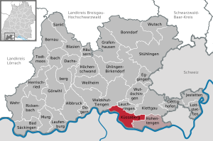
| Location of the municipality of Küssaberg in the district of Waldshut | ||
  |
||

Küssaberg is a municipality in the Waldshut district in Baden-Württemberg on the Swiss border . In Küssaberg the most important traffic connection with Switzerland runs between Waldshut-Tiengen and Schaffhausen over the Rhine bridge Zurzach-Rheinheim . The landmark of the district of Waldshut is the Küssaburg located in the Küssaberg district .
The northern foothills of the Alps and southern Germany came into the light of datable history through the ancient historian Strabo , who launched the Roman Alpine campaign in 15 BC. . Chr described, continued to its conclusion at a legion Zurzach / Küssaberg on the Upper Rhine. This information became verifiable through the discovery and excavation of the Roman camp in Dangstetten from 1967.
See also: History of Küssaberg
geography

Küssaberg is located on the southeastern edge of the Black Forest and is part of the Klettgau landscape . The community is located on a plain that is bordered by a mountain range of the Randen and in the south by the Upper Rhine . The municipality covers 26.20 km²; 10.18 km² are forested, the agricultural area is 12.62 km². In the area characterized by forest and agricultural use, there is a commercial district shielded from the living areas.
location

The Randen mountain range with the Küssaburg ruins at a height of 634 meters forms the border to the municipality of Hohentengen on the Upper Rhine in the east, to the municipality of Klettgau in the northeast and to the municipality of Lauchringen in the northwest . In the West through a bottleneck near the mouth of the Rhine tributary Wutach the national road 161 in the area of the towns Waldshut and Tiengen .
On the Swiss side is the canton of Aargau with the spa town of Bad Zurzach and the communities of Mellikon , Rekingen and Rietheim . The city of Zurich is 30 kilometers away.
Further environment
Küssaberg is roughly halfway between Basel and Lake Constance ; to Freiburg and the French border ( Vosges ) it is 80 to 120 kilometers; to the north are the Feldberg , Schluchsee and Wutach Gorge in the Black Forest , to the northeast the former cannon railway and today's museum railway . The Rhine Falls of Schaffhausen are 20 kilometers away . The connection to the A 81 motorway is also located here . In the south, Zurich-Kloten Airport can be reached in an hour's drive.
See also: Brief tourist description
Affected by COVID-19 pandemic
The COVID-19 pandemic spread to all rural areas in Baden-Württemberg in March 2020. Until the middle of the month, the district of Waldshut and the communities located here, including Küssaberg, were little affected by illnesses or even deaths. The comprehensive measures of federal government institutions in the country, the regional councils , and the district itself were followed without exception.
- With 8 sick people and a rate of 1.43 / 1000 inhabitants, the municipality of Küssaberg is considered “little affected” (mid-August 2020).
The community
The municipality of Küssaberg consists of the villages of Bechtersbohl , Dangstetten , Kadelburg , Küßnach , Reckingen , Rheinheim and the Ettikon settlement, which were independent until the 1970s . This includes numerous courtyards and historically former settlement areas in the respective surroundings.
See also: The localities
Since the community reform there has been a community administration association with Hohentengen on the Upper Rhine . Since the 2013/14 school year, the “Rheintal” community school has been set up with the neighboring community as a secondary school on site with two locations in the participating communities; The classes from 1–10 are divided according to age group and are taught by 37 teachers.

A central concern of the community is residential development - a residential area in Kadelburg is a model for a rural community. The new fire station with DRK rooms was inaugurated on April 8, 2018. In Kadelburg, the town center is to be redesigned (by 2022) "so that shops and service providers can develop and position themselves better." The supermarkets have to move, and "common areas" are also planned.
- For the administrative community see: The political community
- For churches see: Religious Communities
Features of the modern civil parish
The obvious characteristics of prosperity and a reflected approach to its prerequisites have, on the one hand, historical reasons such as general social renewal and economic prosperity in the post-war period in West Germany, as well as specific conditions that can be traced back to the neighborhood to Switzerland.

Development policy background
No region was spared the family tragedies caused by the high number of war deaths after the Second World War, but there was hardly any destruction in southern Baden and the hunger winter of 1946/47 was also alleviated by the Swiss neighborhood aid. Since the central Upper Rhine region is close to the economic and industrial metropolis of Zurich and its surroundings, a high percentage of the German population found well-paid jobs in the neighboring Swiss cantons from the 1950s onwards, and the Swiss population uses the still existing currency differential for permanent shopping - and leisure activities in the German border area.
Services

Since the community reform in the mid-1970s - as the administration emphasizes in the self-description as services - "a community center with a secondary and technical secondary school (today's GMS Rheintal), two sports halls (Küssaburg-Halle in the community center in Rheinheim and a sports hall at the Elementary school in Kadelburg), outdoor sports facilities, spacious municipal building yard and town hall. "In addition, there are supply facilities including" a drinking water network with 4 deep wells, over 50 km pipeline network and 10 elevated tanks. "In four kindergartens (Dangstetten, Kadelburg, Rheinheim and the forest kindergarten on the hill at the Küssaburg) the youngest are looked after; the primary school is in Kadelburg. "Living in old age" is a cooperative project 'set up' by the community and committed citizens:
Civic community
The Bürgergemeinschaft Küssaberg came into being in 2016, “when the local seniors 'council, the municipal senior citizens' organization, the neighborhood help and the social welfare association merged. […] The association now has more than 700 members. ”40 voluntary helpers - including 17 drivers for the“ Citizens' Bus ”, which regularly drives four days a week and is individually accessible and coordinated by the community - ensure an extensive range of Services.
"Living in old age"
The central project of the community with the municipality is "the preparation and implementation of a 'fully self-managed residential community" "in a building project," the autonomy of living for older people and participation in social and cultural life, for citizens of Küssaberger Need for help or support "realized: The citizens' community characterizes the internal organizational form of the project as" an offer and option for different types of housing, such as age-appropriate apartments or living in a self-managed shared apartment ". “The project comprises eight two-room projects and a flat share with twelve places and is estimated at four million euros. […] The first groundbreaking is planned for autumn [2018] so that the first residents can move in in 2020. ”According to internal information, the community expects work to start in spring 2019 due to the high workload of construction and craft businesses in the region A delay in the start of construction is confirmed by the municipality, justified by the application for a further subsidy for a new funding program : "A decision by the approving authority is only expected in a few months, so that by then, to avoid financial disadvantages, the Construction has to be awaited. "
Further work areas of the community are:
.jpg)
- Neighborhood help (with the placement of handicrafts in the house and garden for seniors)
- a regular 'Internet (t) meeting' "on the part of so-called silver surfers"
- Events with "young and old" for communication between the generations.
Refugee aid
"In Küssaberg around 70 refugees have found a new home." (June 2018). A refugee helpers group made it possible “that jobs could already be found for individual refugees. Thanks to the voluntary helpers of the working group, every family or individual has a so-called sponsor. "

Culture
In addition to a diverse club life that sets its own cultural accents, the Museum Küssaberg , founded in 1985, offers continuity with an extensive exhibition program that changes around six times a year. The original motif of the foundation, the Roman past of Küssaberg, is served by the vaulted cellar of the imperial hunting lodge and former council house of Rheinheim - here there are replicas of the most important objects from the Roman camp in Dangstetten and original, also dendrochronologically recorded, foundation posts made of oak from an ancient Rhine bridge as well as studies and models for the Roman bridge construction.
.JPG)
Tourism
The municipality's tourism activities are to be intensified with the construction of a central contact point and thus improved organizational possibilities. "A well-marked and well-maintained network of hiking trails [which was included in the signposting of the Black Forest Association in 2001] and thus supra-regional and cross-community in the hiking plan" seems unspectacular.
“In 1963, holiday guests stayed 15,000 times” in the village of Kadelburg. In 2016 the number of overnight stays in Küssaberg was 30,000.
Special features are a mini golf course with 'chicanes' designed by artisans as well as canoeing and soft rafting tours on the Rhine, including crossing the Lauffen near Ettikon .
For the sights of the municipality see: Sightseeing
nature
Küssaberg is located within a "network of protected areas [in which ..] biological diversity and the European natural heritage are (should) be preserved through the preservation of natural habitats and wild animals and plants."
Nature reserves
- Lauffen near Ettikon ( rapids in the Rhine)
- Küssaberg nature reserve
- Pulsatilla location in Dangstetten
- Orchid meadow Küßnach
Economy and trade

"Küssaberg has always been a community of craft and production." The number of employees rose from 1219 (1995) to 1470 (2015). “There are currently 386 business registrations in the community.” The Rhine bridge loads three places with through traffic and, on the other hand, brings Swiss customers and guests directly into the community.
Handicraft Handicraft has
a long tradition - here too the Romans could have been the godfather, because around the Dangstetten legionary camp there was a 'camp town' with the necessary trade, workshops and entertainment. Four blacksmiths are still noteworthy, even if today they see themselves primarily as artistic blacksmiths.

Industry
Küssaberg is also keeping up with the competition between the municipalities for business settlements on the Swiss border - in the “Greut” business park near Kadelburg, only manufacturing and craft businesses are permitted. The spectrum of production ranges from gravel mining and processing, to stirring systems for the food industry, to precision engineering (including body parts) to electronic components.
Traditional gastronomy
The old inns go back to an ancient, if hardly documented history: Originally Roman road stations could have been the Der Engel inn in Rheinheim (with a scallop shell as a relief) and the Hirschen inn in Bechtersbohl; The inn in front of the Küssaburg and the inn Küssaberg in Küßnach also have a long history.
Services
The range of service providers that is common for rural areas is available in all localities - including increasingly therapeutic and curative providers whose clientele primarily comes from the urban area south of the High Rhine.
Media
The daily newspaper Südkurier is in Küssaberg with the traditional newspaper Alb-Bote , whose local section corresponds to that of Südkurier, but has this as the title and main section. In the weekend supplement, the Alb-Bote runs the 'Waldshut storyteller', who deals with historical and cultural topics from the region. The Badische Zeitung is also present with the Heimat section. There is also the "Hochrhein Anzeiger" advertising paper, which is also editorially active. Online reports hierzuland.info on the town and the surrounding villages.
Internet
Internet and mobile phone reception are not yet guaranteed nationwide, but - as in the entire region - expansion is being pushed. In the 2018 budget, the municipality has earmarked € 100,000 for broadband coverage in the localities of Bechtersbohl and Küssnach. The community is connected to the local provider hochrheinnet .
The localities
| coat of arms | District | Population (as of 2018) |
surface |
|---|---|---|---|
| Bechtersbohl | 303 | ||
| Dangstetten | 1126 | ||
| Ettikon | 291 | ||
| Kadelburg | 1856 | ||
| Küßnach | 132 | ||
| Reckingen | 343 | ||
| Rheinheim | 1430 |
Village portraits
"History does not begin with the beginnings, but only with the written transmission of the events." Wrote the local history researcher Emil Müller-Ettikon in 1981. Today, archeology, with increasingly differentiated methods, extends less knowledge about events, but ideas about the way of life in early cultures - often about remarkable craft techniques.

- Kadelburg is the oldest settlement in the community, and finds have been attested since the Stone Age. The reason for the importance of the place since the early days was the connection of a nearby, easily fortified place (hill with mountain church) with a ferry station , which was made possible by the river calming in the backwater of the Ettikoner Lauffen . As a result, the place was a trading center - interrupted only in the two centuries of Roman times, when the Zurzach bridge turned into an urban center ( Tenedo ) and the military and trade route passed Kadelburg via the Rheinheim bridgehead. After the bridge was destroyed in the 5th century, this changed again and in the Middle Ages and through the later affiliation to Zurzach (Confederation) and then also stimulated by the fact that there have been two denominations since the Reformation, Kadelburg regained its importance and is to this day the cultural and economic center in Küssaberg. Symbols for this importance are the Kelnhaus as the former seat of the Vogt (a kind of early 'mayor') and the large historical customs house. The decision to set up the political center near Rheinheim made for a balance in the 20th century.

- Also Küßnach can be a very old place, it was a typical retreat - a settlement site that allowed to withdraw in case of danger to the well entrenched place of kissing the mountain. The name indicates a Celtic origin. The place is still the smallest settlement in Küssaberg with only little through traffic to the farms or to Hohentengen , to whose parish it belonged until 1966.
- The origin of Rheinheim lay in its function as a bridgehead of the Roman times with the establishments of the control and travel trade. Today residence and traffic junction (Rheinheimer roundabout). The community center of Küssabergs is located in the western periphery - to the northeast is the gravel works, the former location of the Roman troops from 15 BC. BC, already on the Dangstetten district. After their victory over the Alamanni around 500 AD “the Franks secured the natural means of transport through their home locations . According to this, Rheinheim would have been founded [on Roman foundations] at the beginning of the 6th century. ”Rheinheim was“ on a side route to the great pilgrimage route to Santiago de Compostela . The southern German pilgrims first visited the Verena shrine in Zurzach. The high point of the German pilgrimages to St. James was around the year 1500. "It is reported that" after 1500 in Rheinheim a lot of building activity began. Numerous public buildings made of stone were built. Rheinheim became a small 'monastery town'. [...] The Rheinau monastery had its secular administrative seat here. "
- Dangstetten will also have emerged as a settlement area in connection with the trade route to the north, which certainly existed before the Romans; Cattle breeding was possibly in the foreground here, because the name can be derived from the Alemannic word "Tang", which referred to a small lake as a watering place for cattle. The Hinterbach used to have a higher water flow. The narrow street village is today affected by a high volume of traffic. The Roman road presumably (because of the flood threat) did not run along the valley floor, but on the northern slope to the hill at the Bechtersbohl cemetery.
.jpg)
- The name Bechtersbohl indicates an Alemannic foundation, but it had its origins in settlements at the top of the pass - in olden times there were haulage companies here that provided the train service for heavy wagons from and down to the Klettgau level. The Romans probably designed the route with two lanes with grooves carved into the pavement - two of these track stones are still installed in the circular area of the Küssaburg. In ancient times, a protective wall and probably also a customs wall is said to have led across the hill. The gentle slope in the Klettgau level was built on in Roman times, including a Gallo-Roman temple . Today Bechtersbohl is the place of residence with a large company building and the access to Küssaburg.

- Reckingen is located in the eastern part of Küssaberg near the German-Swiss power plant across from the community of Rekingen on the other side of the river. Here the origin in a court and the clan of an Alemanni named Recco is assumed. This is indicated by the place-name broadcast - ingen. Complete small town center with a church and inn and “several houses that survived the Thirty Years War.” Here, too, there was a ferry “since time immemorial”, which became superfluous with the transition to the power station.
- To the west of Kadelburg, the Küssaberg industrial park adjoins and leads to a narrow area formed by the last branch of the Randen mountain range, the Homberg and the Wutach estuary into the Rhine. There the settlements Homburg (district of Waldshut-Tiengen) and Ettikon , origin is the Ettikoner Hof at Lauffen there . In ancient times this was crossable as a ford when the water was low - according to a local, oral tradition (recorded by Emil Müller-Ettikon ), it was supposed to be there on a New Year's Eve around 110 BC. The Cimbri and Teutons crossed the river on their way to Italy. In Ettikon there is a workers' settlement of the former Lonzawerke near Waldshut (today: Hochrhein Business Park ).
Settlement structure
The village of Bechtersbohl and the farms Eichhalden and Küssaberg near the Küssaburg belong to the former municipality of Bechtersbohl. The former community of Dangstetten includes the village of Dangstetten and the Geißernhof farmstead, as well as some repatriate farms that are located outside Dangstetten in the direction of Reckingen. The former municipality of Kadelburg includes the village of Kadelburg and the Ettikon settlement and homestead with the Ettikonerhof, near the 'Lauffen' rapids. The village of Küßnach and the farms Alkenhof, Hauackerhof, Markhof, Rohrhof and Stüdlehof belong to the former municipality of Küßnach. Only the villages of the same name belong to the former communities of Reckingen and Rheinheim.
The Riffenhausen desert lies in the area of the former municipality of Dangstetten . In the area of the former municipality of Küßnach is the abandoned town of Haslenhof.
The political community

The municipality of Küssaberg was created on January 1, 1973 through the merger of the municipalities of Dangstetten, Kadelburg, Küßnach, Reckingen and Rheinheim. On January 1, 1975, the municipality of Bechtersbohl was incorporated into Küssaberg.
The Küssaberg town hall is located in the community center on the western outskirts of Rheinheim (towards Kadelburg).
Administration
The municipality is the seat of the municipal administration association Küssaberg , to which Küssaberg and Hohentengen on the Upper Rhine belong.
Mayor
In March 2013 Manfred Weber was elected as the new mayor of Küssaberg with 98.4% of the vote. After 16 years in office, Mayor Alexander Fink had decided not to run for a third term.
Local
council After the local elections in May 2014, the local council has 18 members in addition to Mayor Manfred Weber as chairman. The distribution by party was allocated to the CDU with 12 seats, the SPD 4 seats and the Greens 2 seats. Kadelburg has 6 council members, Rheinheim and Dangstetten 3 each; Bechtersbohl, Küßnach and Reckingen each 2.
The budget for 2018 was approved on the basis of a budget volume of 17.5 million euros and comprised 3.8 million euros for investments.
Partnerships
Küssaberg maintains partnership relationships with
- La Talaudière in France (Dep. Loire),
- Küssnacht am Rigi in Switzerland and
- Pfaffroda in Saxony .

Religious communities
North of the High Rhine, Catholicism was the predominant denomination for centuries ; south of the border river on the Swiss side, the Reformed Church has dominated since the Reformation by Zwingli . Mostly only after the Second World War, due to the large number of refugees from the east, Protestant communities also formed. For a long time, Kadelburg was an exception, because its centuries-old membership of the Swiss Confederation led to its strong following in the village. However, both communities had to go to church across the Rhine to Zurzach, which led to a variety of problems. Only after the dissolution of the secular rule ( secularization ) of the church and the dissolution of the affiliation of the village to the Zurzach canon both denominations could both denominations establish their own churches at about the same time.
Catholic community

“Kadelburg has belonged to the Zurzach parish since the earliest times. In the village itself, the St. Martins Chapel stood on the site of today's Catholic Church. […] But we don't know when this chapel existed. ”All Kadelburgers - including the Reformed - had to go to church in Zurzach. It was not until 1775 that “the Bishop of Constance determined that a chaplain residing in Zurzach would be appointed for the chapel .” In 1809 the chaplain was elevated to a parish, the chaplain moved to Kadelburg, a new building was approved soon afterwards and “on May 9th The church was finally consecrated in 1833. "
There are Catholic churches or chapels in all Küssaberg villages - today the Catholic parish of St. Martin Kadelburg & St. Michael Rheinheim is an active group . The Ecumenical Men’s Circle Küssaberg is also located here.
Evangelical community
_Evang._Bergkirche.JPG)
Kadelburg is the only community in Baden from Hegau to Markgräflerland that has remained Protestant since the days of the Reformation. That was due to the protection of Zurich. [...] The immediate masters of all Kadelburgers were the canons of the Verena monastery in Zurzach . In the Thirty Years War, however, Kadelburg was burned by the imperial family as a heretic village in October 1633 . The Soldateska made no distinction between Catholics and Protestants. Most of the population was able to flee across the Rhine. Then the Swiss Confederation issued a letter of protection to the place.
For two hundred years there was an 'eternal scramble' between the two denominations for preachers and church attendance in Kadelburg - all Kadelburgers had to cross the Rhine to their church service in Zurzach - until the efforts of the Evangelicals led to the building of the mountain church in 1832: the first Evangelical church "Throughout the Baden Oberland". “Two thirds of the congregation were still Protestant” - in 1911 the Catholics predominated, but after the Second World War the number of Protestants increased sharply due to the refugees from the east, as everywhere in southern Germany. The mountain church (with parish hall) remained the only Protestant church in Küssaberg, the presence of the old parish and the mobility of the citizenry make further facilities superfluous.

Brief tourist description
In addition to some of its own sights, Küssaberg is characterized in particular by the short, central connections to the Alpine foothills of Switzerland. Via Zurich the route leads with road and rail connections through the Gotthard or its pass road in the Milan area into the Italian Po plain . The airport Zurich-Kloten can be reached in an hour's drive.
On the German side, the Hochrheinbahn Basel - Schaffhausen runs through the Waldshut district. Via the A 81 motorway , Küssaberg can be reached bypassing Switzerland via the Geisingen exit in the direction of Stühlingen ( federal road 314 ).
From the direction of Freiburg - Basel , Küssaberg can be reached via a section of the A 98 motorway and federal highway 34 .
The central excursion destination and symbol of the region is the ruined castle and former fortress of Küssaburg , which has a long history of presumably prehistoric Celtic fortifications, a Roman watchtower, an own dynasty of counts and eventful events up to destruction in the Thirty Years War. The former Pallas offers an impressive panoramic view.
See: Tourist Brief Description of Küssaburg
To the east along the High Rhine lie the Rhine Falls, the volcanic Hegau with Singen am Hohentwiel on the way to Lake Constance with Stein am Rhein and Konstanz .
In Küssaberg itself there are numerous holiday apartments, four inns with overnight stays and two guest houses. At Kadelburg there is a campsite that is open all year round. There are some traditional inns. There are fire and barbecue areas on the network of trails in the surrounding area and on the Randen Heights. The municipalities offer a modern infrastructure, woodland is in many cases still natural, and there are also bathing areas in the Rhine. In Reckingen there is an outdoor pool and a campsite.
See also: Wikivoyage: water hiking on the Upper Rhine
The ferry from Kadelburg to the Swiss bank will operate from May 1 to October 14, 2018 on Saturday and Sunday from 2 p.m. to 5 p.m.

Attractions
- The ruins of the Küssaburg castle , which once dominated the High Rhine Valley high above the town, are well worth seeing .
- In the district of Kadelburg, the Wallburg Kadelburg was on the plateau with the mountain church.
- In Kadelburg a footpath runs as a Rhine promenade - historical buildings are the former customs house of Friedrich Theodor Fischer , the Trotte and the Kelnhaus. There is a good view from the mountain church plateau. In summer there is a ferry to the Swiss bank at Barzmühle .
- Catholic church in Rheinheim with organ by Konrad Albiez . Location of the Roman bridgehead (foundations in the small park).
- In Rheinheim, the Küssaberg Museum in the Imperial Hunting Lodge and former Rheinauer Amtshaus. (Open on Sundays). The Zehntscheune and Gasthof Engel are nearby.
- Reckingen power plant
- In Küßnach the Bohnerz-Rundweg with the mine “Erzkessel” .
history
The territory of today's municipality of Küssaberg is geographically clearly delimited by the Randen mountain range and the Rhine and was therefore historically a uniform and independent settlement area for a long time. This means that the history of the 'Küssaberg Region' can be described in a uniform manner up to the Middle Ages - until the villages distinguished themselves independently.
Neolithic
Finds from the Neolithic (in the region around 7000-5000 BC) were discovered near Reckingen (double battle ax), near Kadelburg ("Ertel") and at the top of the Bechtersbohl pass ("on the plain") (after Müller- Ettikon and Gersbach). A stone ax was also found in the rubble dumps around the Küssaburg. Some of the finds are inventoried in the Waldshut Local History Museum.
Megalithic age

The oldest historical monuments in the region come from the megalithic culture - that of the Copper / Bronze Age with the period from 5000 to 2500 BC. Chr. Is attributed. These include the menhir from Degernau and the Lange Stein near Tiengen . It is striking that these stone settlements can be found at important river or height crossings, regionally there are also other, little-known menhirs, such as the menhir of Nöggenschwiel , others near Dettighofen, near Mauchen and between Stühlingen and Schwaningen. In the case of the latter, the menhir can be assumed in the later processing as a base for a crossroads. This could also apply to the ensemble that can be observed at the Bechtersbohl cemetery: altitude, there presumed leadership of the Roman road to Dangstetten, possibly also on site unusual, possibly transported stone material. Investigations have not yet taken place.
Late Bronze Age
The Bronze Age is estimated in Central Europe to 2200-800 BC. . Chr recognized in the Raumschaft attributed rather late period (from 800: Hallstatt period ). The method of burial for higher-ranking people in burial mounds (men with weapons, women with jewelry) already gives archeology differentiated knowledge. In the Küssaberg area "[1901] the farmer Klauser found two women's graves in his gravel pit southwest of Dangstetten" with a large number of pieces of jewelry. Nine probably untouched hills lie in the Gewann Emmerich near Homburg and near Ettikon. “The total stock in the eastern district of Waldshut amounts to approx. 350–400 hills.” Contrary to representations in local research, the local barrows are not assigned to the Celts. These were already processing iron.
Celts
The Celtic period is dated to 450 BC. Dated to the turn of the millennium. Küßnach and Kadelburg are considered to be larger Celtic settlements, and there are also numerous hilltop castles that are accepted as refuges for scattered courtyards. Probably on the Küssenberg and certainly near Kadelburg in the “Egghau” ( Viereckschanze ): “But the Kadelburgers completely destroyed their old building with the decline of progress. The trenches of the castle served as a garbage dump. ”Historically, increasing conflicts in southern Germany from the 2nd century BC onwards are evident. Assumed when the Germanic tribes began to push from north to south. (Climate changes should also have played a role here). The Celtic tribe of the Helvetii originally settled in the Main / Tauber area and then migrated to the Alpine foothills.
This movement becomes historically tangible after the Celtic tribes of today's Baden-Württemberg and western Bavaria, led by the Helvetii, set out on a huge trek in southern France after the destruction of their own villages. However, the Romans already counted these regions among their core areas and Caesar defeated the emigrants in 58 BC. Annihilating with rapidly assembled legions ( Battle of Bibracte ). The surviving third was brought back, incorporated as Roman allies (foerderati) and should serve as a 'buffer' against the Teutons. Caesar subsequently used the location to 44 BC. To conquer all of Gaul - today's France. He blocked the Germanic peoples along the entire length of the Rhine and it remained quiet in the Upper Rhine region. Presumably the Celts were now concentrated in their own larger cities, the "oppidum" near Altenburg-Rheinau has been proven in the region .
.JPG)
Romans
After Caesar's assassination, the entire empire got into a long-lasting civil war, which was fought with troops on both sides and from which Octavian emerged victorious: he then rose to become (first) Emperor Augustus and, as sole ruler, reorganized the situation in Rome and stabilized it militarily first the border regions around the Mediterranean. The north was particularly problematic, as the mountain tribes of the Alps repeatedly invaded northern Italy.
In the course of several campaigns , the Romans subjugated the entire Alpine region, built several pass roads and civilized the Alpine foothills, which had already been controlled by Caesar as a base, up to the Upper Rhine in their favor. At the end of the last pincers-like campaign , the western army group under Tiberius 15 BC continued. BC also across the river to secure the apron to the Danube springs. This date is the first historically guaranteed point in the history of southern Germany and thus also Küssaberg: The XIX. (19.) Legion crossed at Zurzach / Rheinheim. However, the translation point is not named in the historical tradition, it could only be determined in 1967 after the discovery of the so-called "Roman camp Dangstetten" . The camp with 6,000 men, auxiliary troops and a huge baggage train (camp village) was evidently found in coins from 15–9 BC. Occupied.

During this time, the land was presumably secured as a demarcation up to the Wutach; a watchtower on the Küssenberg is generally assumed, because here the old trade route, which has now been converted into the Heeresstraße, led over the Bechtersbohler pass and on via Erzingen, Hallau to Schleitheim / Stühlingen. Presumably, the connection to Fort Hüfingen (Brigobanne) on the Danube was already secured , because the lands of the Balkans along the river were already Roman. Perhaps the southern access to Germania should also take place here, but then there were unknown changes in the strategy, because the attack on Germania was only carried out further north and failed in the battle in the Teutoburg Forest . The 19th legion stationed in the Dangstetten camp (today the excavated area of the Tröndle gravel pit) perished there. For a few decades there was presumably a status quo, the so-called "Black Forest Campaign" did not take place until 72/73 AD - it was more of a large-scale road construction company, because an army road was built from the Danube through the forest to Strasbourg ( Argentorate ) guided. This is mainly because the way for troops to be moved from the Balkans to Gaul and vice versa was greatly shortened, because until then the legions - and also the commercial traffic - had to make the detour around the Basel Rhine knee. The Black Forest (“Silva Marciana” on an old Roman road map ), however, remained a primeval forest-like, inaccessible region in which smaller ethnic groups and scattered Celts had settled. Southwest Germany was probably also called Agri decumates by the Romans .

For 150 years peace reigned in the south, secured by the Limes , the country was developed closely with roads and manors , cities were formed in Zurzach ( Tenedo ) with the bridgehead Rheinheim and at Schleitheim-Stühlingen ( Juliomago ).
Various fronts, internal disputes and, above all, the peoples advancing from the east and north created permanent unrest on the borders of the empire in the 3rd century AD and in 213 AD there were first battles with groups of warriors called "Alemanni" around the Limes .
Alemanni

Today it is assumed that the " Alamanni " were not an actual tribe, but rather young teams from different peoples who wanted to take action against the Romans on their own and broke into the hinterland again and again in the first decades [name interpretation: "all (able-bodied) men"]. The first big onslaught took place in AD 259 - even the Roman cities in today's Switzerland ( Windisch bei Baden , Kaiseraugst , Avenches ) were reduced to rubble: “They pushed as far as Italy and even threatened the Eternal City of Rome. But Emperor Gallienus defeated them devastatingly at Milan. ”The Romans went back to the Rhine line, but they probably held the Klettgau plain to Iuliomagus (Schleitheim) , the town near Stühlingen-Schleitheim. In this phase, the Rheinheim bridgehead is fortified and the fort opposite near Zurzach is built. "For two centuries there was war and constant unrest in the country." However, recent research suggests a long period of 'coexistence' and even trade after the High Rhine Line was fortified. After the 4th century the Romans even built a stone bridge, "[renewed] in the years 368 and was defeated 376th" whose wooden parts Only 401/406 n. Chr. The last Roman troops to Italy were to fight against the Visigoths withdrawn . Now the Alemannic conquest could begin. The question of what happened to the Gallo-Roman population is answered as follows today:
“Although the economic system of the villa rustica ended in the 5th century AD, a decisive break in the cultivation of the cultivated land cannot be proven everywhere. The Romansh population was not driven out or even exterminated. One can only observe that the temporally and regionally different immigration of Germanic tribes of different origins in the course of the early Middle Ages led to a gradual assimilation of the Romanians into a numerically superior Germanic population. "
Francs
At the beginning of the 6th century AD, the two great Germanic tribes that settled the regions around the Rhine after the retreat of the Romans waged a struggle for supremacy, which the Franks in two or three battles due to their adoption of Roman culture and state organization could decide for themselves. The rejection of 'everything Roman' by the Alemanni had gone so far that they also avoided the Roman settlement areas and remained in the wooden construction. After their victory, the Franconian Merovingians crossed the Alamania with bases and new settlements, which they built exactly on the former Roman infrastructure, the former cities and places of Roman villas and transport hubs. The places ending in -ingen are assigned to the Alamanni, the places ending in -heim den Franken.
In the 9th century the administrators of the Merovingian kings, the Hausmeier, took over power and, after Karl Martell , went down in history as the Carolingian. Its most important representative was Charlemagne , who created the 'Gau division' in the Franconian Empire around 800 (Klettgau, Alpgau).

middle Ages
Documented, that is, recorded in written documents, the existing localities are all in Carolingian times through donations from the Klettgaugrafen Gotsbert in the 9th century to the Rheinau monastery . The award documents date to the year 876.
In the centuries of the supremacy of the Franks - regionally, Alemannic independence continued to exist for a long time and there were also several uprisings - Christianization was a hallmark of Central European development. The monasteries became dynamic centers of economy, education and culture - and, as targets for the influence of the noble houses, became focal points of political power. "The church became the strongest pillar of the Franconian royal family." The Klettgau came under the influence of the Rheinau monastery and its offshoot, the St. Blasien monastery , and the Reichenau abbey .
A Swiss source (Johann Acklin, 1665–1690 Stiftsamtmann) describes medieval bridges: "The one above at Reckhingen called by the Wartbaum, just past the Schifmüllin" and a second immediately east of the present-day Zurzach-Rheinheim bridge, whose wood was "dedrochronological ( Annual ring measuring method) […] dates back to the 13th century. “It is the time of the prosperous, peaceful phase of the Middle Ages with minstrelsong , swordsling (accolade); the epic Parzival .
There is evidence that Küssaburg had its own house for more than 100 years, the Counts of Küssenberg (1135–1459) and then became the property of the ecclesiastical 'overlord', the Bishop of Constance . The castle played an important role in the following centuries of ever larger territorial domains - large aristocratic houses, urban centers, the Swiss Confederation - and came into the possession of the Counts of Sulz in 1497 . The Middle Ages are considered to have faded from the Peasants 'War [1524/25] - after the Reformation , which also led to iconoclasts in Küssaberg - the Thirty Years' War [1618–1648] developed from regional conflicts into a European power struggle that led to great devastation in southern Germany and in 1634 also led to the destruction of the Küssaburg . After the death of the last Count von Sulz, the princes of Schwarzenberg with residences far away came into the possession of the Klettgau.

Modern times
The centuries of endless feuds, troop marches, massacres and pillages were finally put to an end by Napoleon , who with his 'reorganization of Europe' finally adopted the medieval living conditions through the creation of large state units:
“But it wasn't just the political situation that changed. If we commonly equate the discovery of America by Christopher Columbus with the beginning of modern times (1492), agriculture was only released from the shackles of the early March, that is the time between the Congress of Vienna (1815) and the revolution of 1848 Middle Ages. Nobody thought of a redesign beforehand. This change in peasantry took place at the same time as the transition from high industrial culture to industrialism. […] In addition to the liberation of the peasants from above, such as the abolition of serfdom , the abolition of compulsory labor, tithe redemption and the capitalization of duties [taxes], there was a desire for a rapid increase in income. [...] then came the triumphant advance of technology. "
Until 1805 the community was part of the Landgraviate of Klettgau , only Kadelburg was an external office of the County of Baden . In 1805 Kadelburg and the Klettgau on Baden came to the Waldshut office. In 1847 the flying bridge to Rietheim was opened, which was in operation until 1939. In 1907, the Zurzach – Rheinheim bridge on the Rhine established a road link to Switzerland.
The era of the struggles of the nation states emerging with industrialization for rule in Europe and its environs led to the First and finally the Second World War , which ushered in globalization that had not come about peacefully.
The reorganization of living conditions after the last war also benefited Germany, the loser of the war, which was able to reorganize itself on all levels and, thanks to the peaceful resolution of the East-West conflict , is gaining political importance again in addition to economic influence within the European Union . This ultimately also affected the traditionally stable conditions in rural regions that were reorganized in the early 1970s.
post war period
After the Second World War, the traditionally small-scale social and political structures - the independent (village) communities - had organized economic and social survival, but during the reconstruction and economic miracle of West Germany they seemed to stand in the way of the dynamism of modern developments at all levels : From the 1960s, the state structures were reorganized and after the state and district reforms it was also about ...
“... to form larger, more efficient municipalities, which are to receive new administrative responsibilities and to be able to carry out more economical and more effective planning and investments across the old municipal boundaries in the new municipalities. Initially, the state of Baden-Wuerttemberg and politicians recommended a voluntary community merger. The communities that joined together on a voluntary basis had received a merger premium (in the vernacular "community slaughter premium") from the state of Baden-Württemberg. "
This suggestion was “heatedly and sometimes passionately discussed.” Originally, larger units were also considered: integration into Waldshut-Tiengen or merger with Hohentengen, but the citizens of the Küssenberg region, which had also been grouped together historically, agreed on their own Connection, for which the names "Küssaberg" and "Küssenberger Tal" were also available. Citizens' surveys were carried out and in December 1972 the municipal councils of Dangstetten, Kadelburg with Ettikon, Küßnach, Reckingen and Rheinheim decided to merge voluntarily on January 1, 1973. Only Bechtersbohl had already voted in July 1972 for a merger with Lauchringen. The municipal council seats were distributed according to the population.
By law, Bechtersbohl was incorporated into Küssaberg by the state parliament on January 1, 1975, since "the stronger historical and infrastructural links to the Küssaberg area and the closed topography are decisive". Before that, however, a second hearing had been held in Bechtersbohl, at which "59 citizens voted for Küssaberg and 58 citizens for Lauchringen." Paul Stoll concluded in 1981: "Many citizens were [...] not enthusiastic", but in those that followed the merger Years through the "construction of a central, mechanical-biological wastewater treatment plant, renovation and expansion of the drinking water supply, establishment of kindergartens, construction of a new secondary school [instead of the village schools] and all-weather facilities in the community center, expansion of roads [...] has (this reform) the critical Pass an exam."
The author concluded his contribution with the remark:
“If in the last third of the 20th century, the years of reform euphoria, the independence of the communities had to be sacrificed, the citizens should feel just as committed to the history of the past as they did before. We should be more open to history anyway. It is instructive, sensible and also quite useful to consider past experiences, to know the historical context. In this way it is avoided that every generation repeats the same mistakes. "
Contemporary history
An event of international importance was the building of a military bridge between Germany and Switzerland , the only joint exercise that has taken place so far by the Bundeswehr and the Swiss army with the construction of a crossing over the Rhine near Bad Zurzach and Rheinheim combined with the respective bridge systems ( truck ferries and pontoon boats ) by pioneer units from 22.-27. June 1995.
Personalities
- Emil Müller-Ettikon (1911–1985), writer and historian
- Alphons people (1836–1873), emigrated to the USA, poet
- Christian Roder (1845–1921), archivist and historian
- Karl Friedrich Würtenberger (1838–1911), businessman, honorary member of the Russian Academy in St. Petersburg and local poet
Remarks
- ↑ This would also have included the Küssaburg Lauchringen. Although the castle terrain was assigned to Küssaberg in the further course, both communities share part of the responsibility in the Küssabergbund to this day .
Web pages
- Website of the municipality of Küssaberg
- Catholic Church website
- Website of the Evangelical Congregation
- Website of the community of Küssaberg
- Website of the museum association
- Website from Hierzuland.Info
literature
- Emil Müller-Ettikon : About the village of Kadelburg and its past. Published by the municipality of Kadelburg. 1964.
- Emil Müller-Ettikon: A brief overview of the history of Küssaberg. Published by the municipality of Küssaberg. 1981.
- Hans Matt-Willmatt : The chronicle of the district Waldshut. Vocke Verlag, Waldshut 1957.
- Dirk Kremer: A short history of Kadelburg. Küssaberg 2011. (pdf)
- Wolf Pabst: Little guide through Rheinheim. Küssaberg 2011. (New edition from 1985). pdf
Individual evidence
- ↑ State Statistical Office Baden-Württemberg - Population by nationality and gender on December 31, 2018 (CSV file) ( help on this ).
- ↑ Source: Strabon, Geographika 4, 6, 9.
- ↑ According to research by Südkurier: Sebastian Küster: Corona on the doorstep. Overview of the situation in all municipalities in the region , Südkurier, 22 August 2020.
- ↑ Sabine Gems-Thoma: Concepts for the future. In: Alb-Bote. February 27, 2018.
- ↑ Mayor Weber quoted in: Peter Rosa: The retail trade needs contemporary premises. In: Hochrhein-Anzeiger. May 14, 2017.
- ↑ Küssaberg website .
- ↑ Tina Prause: A lot is better with each other. In: Alb-Bote. 15th December 2017.
- ^ Website of the Küssaberg community .
- ↑ Tina Prause: A lot is better with each other. In: Alb-Bote. 15th December 2017.
- ↑ Küssaberg aktuell , official gazette and newsletter of the municipality, August 31, 2018, front page.
- ↑ Tina Prause: The community invites asylum workers and refugees to a barbecue evening together. In: Südkurier, July 17, 2017.
- ↑ website Museum Association .
- ↑ Lieselotte Noth: The "deer" becomes the "yellow diamond". In: Alb-Bote. August 25, 2001.
- ^ Emil Müller-Ettikon: About the village of Kadelburg and its past. Published by the municipality of Kadelburg. 1964, p. 109.
- ^ Tourism statistics for the district of Waldshut .
- ↑ Information in the chapter: Peter Rosa: A community grows. In: Hochrhein-Anzeiger. December 13, 2017.
- ↑ Hierzuland.info. Retrieved June 15, 2019 .
- ^ Parish, dates ; accessed on June 4, 2018.
- ^ Emil Müller-Ettikon : Brief overview of the history of Küssaberg. Küssaberg Municipality (Ed.), 1981, p. 22.
- ^ Wolf Pabst: Small guide through the village of Rheinheim. New edition of the brochure from 1985, Küssaberg 2011, p. 8 and 11. Küssaberg municipality pdf
- ↑ Hans Matt-Willmatt: The Chronicle of the Waldshut District. Vocke Verlag, Waldshut 1957, p. 74.
- ^ The state of Baden-Württemberg. Official description by district and municipality. Volume VI: Freiburg administrative region. Kohlhammer, Stuttgart 1982, ISBN 3-17-007174-2 , pp. 989-991.
- ^ Federal Statistical Office (ed.): Historical municipality directory for the Federal Republic of Germany. Name, border and key number changes in municipalities, counties and administrative districts from May 27, 1970 to December 31, 1982 . W. Kohlhammer, Stuttgart / Mainz 1983, ISBN 3-17-003263-1 , p. 505 and 523 .
- ^ Tina Prause: Household under one roof. In. Alb-Bote, December 20, 2017.
- ↑ After Dirk Kremer: Brief history of Kadelburg. Küssaberg 2011, p. 12, the Catholic Church was "built in 1820 in the classicist style by building inspector Kaiser."
- ↑ E. Müller-Ettikon: Brief overview of the history of Küssaberg. 1981, p. 34.
- ↑ Information on the history and the quotations in both sections in: Emil Müller-Ettikon: About the village of Kadelburg and its past. Published by the municipality of Kadelburg. 1964, p. 63.
- ^ Barz – Kadelburg ferry .
- ↑ E. Müller-Ettikon: Brief overview of the history of Küssaberg. 1981, p. 19.
- ↑ Joachim Hessel: The Bronze Age burial mounds in the eastern district of Waldshut. In: Land between the Upper Rhine and the southern Black Forest. Ed .: Hochrhein History Association. Waldshut 1998, p. 103.
- ↑ E. Müller-Ettikon: Brief overview of the history of Küssaberg. 1981, p. 19.
- ↑ Both quotations: E. Müller-Ettikon: Brief overview of the history of Küssaberg. 1981, p. 22.
- ↑ Alfred Hitber: District Museum "Höfli" Zurzach. Ed .: Historical Association of the Zurzach District, 1993, p. 84.
- ↑ Thomas Fischer: The Germanic Provinces in Late Antiquity. In: Ludwig Wamser (Hrsg.): The Romans between the Alps and the North Sea (= series of publications of the Archäologische Staatssammlung München. Volume 1). Verlag Philipp von Zabern, Mainz 2000, ISBN 3-8053-2615-7 , p. 207.
- ^ Emil Müller-Ettikon: History of Küssaberg. 1981, p. 24.
- ↑ Alfred Hitber: District Museum "Höfli" Zurzach. Ed .: Historical Association of the Zurzach District, 1993, p. 84.
- ↑ See Grand Ducal Baden Ordinance Sheet for the Upper Rhine District. No. 7 of April 17, 1847. Regarding the “flying bridge” near Kadelburg, pp. 25–27.
- ^ Paul Stoll: Küssaberg today. In: Emil Müller-Ettikon: A brief overview of the history of Küssaberg. Küssaberg Municipality (Ed.), 1981, pp. 7-14. All quotes in the section.

Albbruck | Bad Säckingen | Bernau in the Black Forest | Bonndorf in the Black Forest | Dachsberg | Dettighofen | Dogern | Eggingen | Görwihl | Grafenhausen | Houses | Herrischried | Höchenschwand | Hohentengen am Hochrhein | Ibach | Jestetten | Klettgau | Küssaberg | Leek rings | Laufenburg | Lottstetten | Murg | Rickenbach | St. Blasien | Stühlingen | Todtmoos | Ühlingen-Birkendorf | Waldshut-Tiengen | Weir | Weilheim | Wutach | Wutöschingen
Bechtersbohl | Dangstetten | Ettikon | Kadelburg | Küßnach | Reckingen | Rheinheim