
Rhine Falls


The Rhine Falls ( Alemannic or Swiss German Rhyfall [ ˈɾiːfal ], French Chutes du Rhin , Italian Cascate del Reno , Rhaeto-Romanic Cascada dal Rain ), formerly also called Grosser Laufen (as opposed to Little Laufen ), belongs to Norway with the same high Sarpsfossen the three largest waterfalls in Europe . The Sarpsfossen is richer in water with an average of 577 m³ / s, while the twice as high Dettifoss in Iceland only has about half as much water. The Rhine Falls are located in Switzerland in the area of the municipalities of Neuhausen am Rheinfall in the canton of Schaffhausen (right bank) and Laufen-Uhwiesen in the canton of Zurich (left bank), around four kilometers west of the city of Schaffhausen .
description
On the way from Lake Constance to Basel , the Upper Rhine has several resistant rocks in the way, which narrow the river bed and which the river overcomes in rapids and a waterfall, the Rhine Falls.
The Rhine Falls are 23 meters high and 150 meters wide. The scour in the impact zone is 13 meters deep. With an average water flow of the Rhine, 373 cubic meters of water fall over the rocks in the Rhine Falls (average summer runoff: about 600 m³ / s). The highest flow rate was measured in 1965 with 1250 cubic meters, the lowest flow rate in 1921 with 95 cubic meters per second. In the years 1880, 1913 and 1953 the runoff was similarly low.
The Rhine Falls cannot be conquered by fish, except for eels . This meanders sideways (outside the river bed in the country) over the rocks.
Emergence
The bedrock, which is much older than the Rhine Falls itself, as well as the significantly more recent geological processes during the current Ice Age led to the creation of the Rhine Falls. As a result of the general temperature drop, the first glacier advances into the Swiss Plateau began around 500,000 years ago and shaped today's landscape. Until the end of the Riss glaciation around 200,000 years ago, the Rhine flowed from Schaffhausen west through the Klettgau . This former river bed was refilled with alpine gravel ( molasse ).
About 120,000 years ago the river at Schaffhausen was diverted to the south and formed the Risszeit Rhine channel. The course of the Rhine below the fall basin today corresponds to this channel, which has been refilled with gravel.
During the last ice age, the so-called Würme Ice Age, the Rhine was pushed in a wide arc towards the south and reached its current bed on hard Malm limestone above the fall (Weissjura, Upper Jura ). At the transition from the hard Malm limestone to the easily removable gravel channel from the crack age, the Rhine Falls in their present form came into being around 14,000 to 17,000 years ago. The Rheinfallfelsen (large, climbable rocks and the legend of Seelentanzstein ) form the remains of the originally steeply sloping limestone flank of the former drainage channel. The very little erosive deformation of the fall section to date can be explained by the low level of haulage ( river debris ) of the Rhine below Lake Constance .

tourism

Viewing platforms can be reached on both sides of the Rhine on developed paths. Some of these protrude far beyond the Rhine. Schlösschen Wörth is located on the Rhine Falls basin in Neuhausen am Rheinfall . From here you can take excursion boats up to the Rhine Falls and let yourself be dropped off at the middle rock. The ascent of the viewing platform with a close view of the fall is via narrow and steep stairs. In addition, small and large Rhine Falls tours as well as a translation to Laufen Castle , which towers above the Rhine Falls in Laufen on the Zurich side and, among other things, are offered. a. is used by a youth hostel. On the southern side of Laufen Castle, the paths were renovated in 2008 and a glass elevator was installed. Parts of the paths - the so-called adventure trail, including the viewing platforms and the lift - are now chargeable. The Rhine Falls are regularly illuminated in the evening, but not all year round, by a lighting system. In 2013 it was visited by 1,300,000 visitors.
There are several restaurants and food stands in all price ranges at the Rhine Falls. The rope park Adventure Park Rheinfall above the Schlössli Wörth offers a special view of the Rhine Falls . The Rhine Falls and other Swiss sights and landscapes on a scale of 1:87 ( gauge H0 ) are shown by Smilestones , the largest miniature world in Switzerland in a former SIG factory building at Neuhausen Rheinfall station.
There are several paths leading to and around the Rhine Falls:
- Small circular route , 3.4 km, 1:00 h
- Rhine Falls circular route , 7.2 km, 1:53 h

reachability
The Rhine Falls is accessible by car, bike easily accessible (bicycle) and public transport. There are large parking spaces in Neuhausen and at Laufen Castle. The access to the Rhine Falls is signposted from the A4 motorway . Schaffhauser from the station can be reached by the trolley of the line 1 direction Herbstäcker to the stop Neuhausen center (also accessible by the bus line 6 towards Neuhausen SBB ). From there, follow the yellow markings on foot. We recommend the DB train station Neuhausen Bad Bf for visitors who arrive by Hochrheinbahn . This is only a few minutes' walk from the Rhine Falls. The Neuhausen Rheinfall stop has been located north above the Rhine Falls since 2016 . It is served by the SBB S-Bahn S-9 Schaffhausen – Neuhausen Rheinfall – Zurich – Uster, and S-22 Singen – Schaffhausen – Neuhausen Rheinfall – Jestetten. Two passenger elevators at the stop go directly to the Rhine Falls. At Schloss Laufen on the other side of the Rhine, there is also the SBB Schloss Laufen station on the Rhine Falls of the Rhine Falls Railway Schaffhausen - Winterthur .
Between the Rhine Falls and the landing stage in Schaffhausen operates in the summer months the tourist train Rhyfall Express and connects the Rhine Falls with the ships of Swiss shipping company Untersee and Rhine .
Economic use
Rhine power station in Neuhausen

Mills at the Rhine Falls, which used small parts of the hydropower, have been in operation since ancient times, especially on the north side. In the 17th century, a blast furnace for smelting floor polish was built on the right side of the fall and operated for about a century and then again in the first half of the 19th century. At the beginning of the 19th century, Johann Georg Neher was given rights to use the water power at the Rhine Falls, which remained in his family for a long time. The power plant supplied the Schweizerische Waggons-Fabrik and, from 1889, the first European aluminum plant of the Aluminum-Industrie-Aktien-Gesellschaft with energy. In 1947 the name was changed to Rheinkraftwerk Neuhausen AG.
The usable water volume of the power plant is 25 m³ / s, which has little effect on the remaining water volume of the Rhine Falls. With a 23 meter gradient, the Neuhausen power plant has an installed capacity of 4.4 MW with one turbine. In comparison, the Schaffhausen power plant located a few kilometers upstream with two turbines has an output of 25.5 MW at a flow rate of 425 m³ / s. Operational management is carried out by the Reckingen power plant , with management by EnAlpin AG , a subsidiary of Energiedienst Holding .
Previous and new plans for use
An application for a license from J. G. Nehers Söhne & Cie. (Eisenwerk Laufen) in 1887 to increase the flow rate in the power plant to 75 m³ / s was not approved by the cantons of Zurich and Schaffhausen. This was opposed in particular by Hermann Freuler , the Swiss Natural Research Society , the Swiss Alpine Club and scientific associations in Switzerland.
In 1913 an international competition to plan a shipping route from Basel to Lake Constance was announced. According to the project draft from the early 1960s, the Rhine Falls should be bypassed as a natural monument by means of a 552 meter long shipping tunnel and a lock behind Laufen Castle. In 1919 the construction director of Northern Switzerland's power plants declared that the construction of a Rhine Falls power plant “must serve the economic interests of the general public”.
Since the landscape at the Rhine Falls was to remain untouched, no large hydropower plant was built at the Rhine Falls itself. In 1944, however, the Swiss Federal Council approved the concession to build the Rheinau power plant , which is located below the Rhine Falls and dammed the Rhine up to the Rhine Falls basin. Construction began in 1952. In 1951 a popular initiative against making the High Rhine navigable was submitted by over 150,000 Swiss citizens, and in 1952 a further popular initiative against the further construction of a power station for the New Helvetic Society under the leadership of Emil Egli , including 49 respected Swiss citizens Hermann Hesse and Carl Jacob Burckhardt , was signed. A vote was held in 1954 on the 1952 petition, which was rejected with 69% of the vote. The plans for making the High Rhine navigable were later discontinued.
On April 10, 2013, the news magazine 10 vor 10 on Swiss television reported on a new power plant project by the Schaffhausen power plants at the Rhine Falls, which would tap the river above the Rhine Falls and thus significantly reduce the amount of water at night. The Federal Nature Conservation and Homeland Conservation Commission and the Canton of Schaffhausen signaled their approval, while the Rhine Confederation expressed its strict rejection. An amendment to the cantonal water management law, which would have enabled another power plant above the Rhine Falls, was rejected by the people on May 18, 2014.
Driving

For a long time, navigating the Rhine Falls was considered impossible. Nevertheless, the Rhine Falls were visited several times with kayaks . In 1999, boat trips between the Flurlinger Bridge and the Rhine Falls were officially banned. However, there are still occasional trips with kayaks, at least once with hand paddles (April 2007), or rarely also in Canadians (January 1997). Some of the pictures and videos are published on the Internet. If the paddlers are caught by the police, they face a fine of up to 5,000 francs.
A mistaken trip with a boat that almost ends in disaster occurs in the 1961 film comedy Three Men in a Boat .
The middle rock of the Rhine Falls, on which the Swiss flag is hoisted, can be reached by small boats.
Rhine fall foam
Since the 1970s, strong foam formation has been observed below the Rhine Falls in summer, the plumes of foam can also be seen for kilometers below. Investigations by the cantonal offices have shown that this is not the feared water pollution from detergent residues or other wastewater. Christian Wegner from the Friedrich Schiller University in Jena has shown in his doctoral thesis that the cause of the foam is to be found in the flooding water tapfoot ( Ranunculus fluitans ).
Representations in art
The Rhine Falls by Joachim Patinir was depicted for the first time in the painting Baptism of Christ (1515–1520). There is a woodcut of the Rhine Falls by Sebastian Münster in Cosmographia (1544). The most important representation is likely that of William Turner , the painting is exhibited in the Museum of Fine Arts in Boston .
- Johann Ludwig Bleuler: The Rhine Falls of Schaffhausen, around 1850. Colored lithograph, Rosgarten Museum , Konstanz
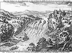
Rhine Falls and Laufen Castle around 1642

Rhine Falls around 1784 , etching by Johann Jakob Aschmann

Philip James de Loutherbourg (1740-1812): Falls of the Rhine at Schaffhausen 1788 Victoria and Albert Museum

William Turner (1775–1851): Fall of the Rhine at Schaffhausen between circa 1805 and circa 1806 Museum of Fine Arts

Konrad Corradi (1813–1878): The Rhine Falls near Schaffhausen. 1860. Gouache. 13.8 x 20.2 cm


Descriptions in the literature
Numerous - also famous - writers visited the Rhine Falls and described it, such as Goethe , Wilhelm Heinse , Mörike and others.
Eduard Mörike wrote about the waterfall: «Hold your heart, oh hiker, firmly in mighty hands! Mine almost fell from me, trembling with pleasure. Restlessly thundering masses thrown upon thundering masses, ears and eyes, where do they save themselves in the turmoil? "
gallery

View from Laufen Castle

Rhine falls during floods in June 2013

Rhine Falls. View below Laufen Castle


literature
- Claudia Heitmann (Ed.): The Rhine Falls: Sublime Nature and Tourist Marketing. Schnell & Steiner, Regensburg 2015, ISBN 978-3-7954-2978-2 . (Exhibition: The Rhine Falls - Sublime Nature and Tourist Marketing : March 7th to June 7th, 2015 in the Middle Rhine Museum Koblenz.)
- Heinrich Gebhard Butz (Ed.): You were at the Rhine Falls: the Rhine Falls in European literature. Texts from the Middle Ages to the present. Anthology . Chronos, Zurich 2009, ISBN 978-3-03-400918-8 .
- Christian Wegner: Ranunculus fluitans and Rheinfallschaum: connections, analysis and ecotoxicological significance. EchinoMeida, Bürgel 2002, ISBN 3-9807629-2-0 (At the same time dissertation Uni Jena 2001 under the title: Ranunculus fluitans Lamk. And Rheinfallschaum. )
Web links
- Robert Pfaff: Rhine Falls. In: Historical Lexicon of Switzerland .
- Official website for the Rhine Falls
- City archive Schaffhausen: historical photos
- The Rhine Falls in old views and descriptions ( Wilhelm Heinse , Goethe ) - project of the Ludwig Maximilians University in Munich
- Old photos of the Rhine Falls at photohistory
- Old photos from the Rhine Falls ( memento from November 7, 2011 in the Internet Archive ) at schaffhausen-nostalgiefoto
- Spherical panorama from the rock in the Rhine Falls
- René Härri: Rehabilitation of the two Rhine Falls rocks . In: Swiss engineer and architect . doi : 10.5169 / seals-75790
Individual evidence
- ↑ NZZ, September 23, 2016, page 66
- ↑ Legend: The fisherman at the Rhine Falls
- ↑ Shipping: Rhyfall Mändli
- ↑ Shipping: Schiffmändli
- ^ Reto E. Wild: Travel destination Switzerland. In: Migros Magazin , Zurich July 13, 2015, page 8.
- ↑ Adventure Park Rheinfall
- ↑ The miniature world of Smilestones
- ↑ Rhine Falls: Hiking
- ^ Rhyfall Express
- ↑ EnAlpin website: Rheinkraftwerk Neuhausen AG ( Memento from July 24, 2014 in the Internet Archive )
- ↑ A. Uehlinger: The nature conservation efforts at the Rhine Falls. In: Schweizer Naturschutz , 7 (1941), pp. 95-102.
- ↑ Alfred Barthelmeß : Landscape-Habitat of Man. Verlag Alber, 1988, pp. 165 ff. Digitized
- ^ Fonto: News bulletin 10 to 10 of April 10, 2013.
- ^ Announcement Rheinaubund: Rhine Falls non-negotiable. (PDF; 102 kB)
- ↑ sh.ch: Change of Water Management Law
- ↑ History of the Rhine Falls visits
- ↑ No regrets about the Rhine Falls departure. SF Tagesschau, November 13, 2006, accessed on July 19, 2009 .
- ↑ Felix Thürlemann : The world in all its diversity. In: Neue Zürcher Zeitung . February 22, 2014, p. 67 , accessed April 25, 2020 .
- ^ Eduard Mörike: At the Rhine Falls
- ^ Christian Wegner: Foam formation at the Rhine Falls , August 2001