
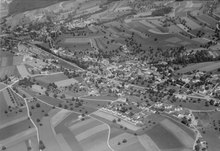
Unterendingen
| Unterendingen | ||
|---|---|---|
 |
||
| State : |
|
|
| Canton : |
|
|
| District : | Zurzach | |
| Residential municipality : | Endingen | |
| Postal code : | 5305 | |
| former BFS no. : | 4321 | |
| Coordinates : | 664 143 / 266679 | |
| Height : | 386 m above sea level M. | |
| Residents: | 362 (December 31, 2013) | |
|
Proportion of foreigners : (residents without citizenship ) |
k, A,% (December 31, 2019) | |
 Unterendingen |
||
| map | ||
|
||

Unterendingen ( Swiss German : ˈnɪdərˌændigə ) is a village in the Swiss canton of Aargau . It is part of the municipality of Endingen and is located in the Surbtal , around four kilometers from the border with Germany . Until the end of 2013 Unterendingen was an independent community in the Zurzach district .
geography

The village is located in the narrow valley of the Surb at the mouth of the Schlierenbach. This east of the village flows through a deeply cut ravine that separates the hills Buhalden and Teufelskanzel each other. Both hills belong to the Table Jura ; the lower, extremely steep area has a height difference of around 150 meters and then turns into a small plateau. To the west lies the Ruckfeld, an extensive plateau that is bordered on its edges by very steep slopes up to 40 meters high. The area of the former municipality was 345 hectares . The highest point was at 544 meters on the Teufelskanzel, the deepest was 375 meters on the Surb. Neighboring communities were Tegerfelden in the north, Baldingen in the northeast, Lengnau in the east, Endingen in the south and Würenlingen in the west.
history
In the High Middle Ages the village belonged to the domain of the Barons of Tegerfelden . Subordinate to them were the Knights of Endingen , first mentioned in 1239 , who owned a small castle south of Unterendingen. After the Tegerfelds died out in 1254, the clan was first associated with the Barons of Regensberg , and later with the Diocese of Constance . The first documentary mention of Nider-Endingen , that is, explicitly with the addition to differentiate it from neighboring Endingen, took place in 1298. The place name comes from the Old High German Antingun and means "among the people of Anto". Around 1305, the Habsburgs acquired blood jurisdiction . Important landowners were the St. Blasien monastery and the Johanniterkommende Leuggern .
The Swiss conquered Aargau in 1415 and Unterendingen now belonged to the Siggenamt of the County of Baden , a common rule . In 1529 a large part of the population converted to the Reformation , but after the Second Kappel War of 1531 had to accept the Catholic denomination again. In 1661, the Catholics from the mixed denominational neighboring village of Tegerfelden built their own church in Unterendingen, which was also used by the residents of Endingen. In 1798 the French took Switzerland and proclaimed the Helvetic Republic . Unterendingen was initially a municipality in the short-lived canton of Baden , since 1803 it has belonged to the canton of Aargau.
After the opening of the Turgi – Koblenz – Waldshut railway in 1859 and the Dielsdorf – Niederweningen railway in 1891, the Surbtal communities submitted a concession to build a connection between Niederweningen and Döttingen . But the First World War prevented the construction of the Surb Valley Railway and the project was finally written off in 1937. The population stagnated for many decades. At the beginning of the 1980s, a larger building zone was developed and the village grew by 80 percent within ten years. On June 15, 2012, the community meetings of Endingen and Unterendingen approved the merger of the two communities. In the referendum on September 23, 2012, the resolution in Unterendingen was confirmed with 118 votes to 35, after which the merger took place on January 1, 2014.
coat of arms
The blazon of the former municipal coat of arms reads: "Split from blue with half a white lily and from red." The community of Endingen decided in 1926 to adopt the coat of arms of the Lords of Endingen. However, after the remains of their castle were discovered in the area of Unterendingen in 1934, this community also claimed the coat of arms. After a complaint to the government council in 1953, the two municipalities came to an agreement: In the meantime it had been found that there was already a coat of arms for Unterendingen on the map of the canton of Zurich from 1667, which only differed in color and was ultimately adopted.
population
The population developed as follows:
| year | 1799 | 1850 | 1900 | 1930 | 1950 | 1960 | 1970 | 1980 | 1990 | 2000 | 2010 |
| Residents | 201 | 254 | 154 | 152 | 159 | 149 | 150 | 189 | 333 | 371 | 371 |
On December 31, 2013, 362 people lived in Unterendingen. In the 2000 census, 50.1% described themselves as Roman Catholic and 34.5% as Reformed ; 15.4% were non-denominational or of another faith. 94.9% said German as their main language, 1.9% Serbo-Croatian .
traffic

Unterendingen is on Hauptstrasse 17 , which leads from Döttingen through the Surbtal and Wehntal to Zurich . Three postal routes open up the village: From Tegerfelden to the station Baden , Döttingen by Niederweningen and from the station Bad Zurzach to Brugg station . On weekends, a night bus runs from Baden via the Surbtal and Klingnau to Bad Zurzach.
Attractions
Web links
Individual evidence
- ↑ Cantonal population statistics 2019. Department of Finance and Resources, Statistics Aargau, March 30, 2020, accessed on April 2, 2019 .
- ^ National map of Switzerland, sheet 1050, Swisstopo.
- ^ Beat Zehnder: The community names of the canton of Aargau . In: Historical Society of the Canton of Aargau (Ed.): Argovia . tape 100 . Verlag Sauerländer, Aarau 1991, ISBN 3-7941-3122-3 , p. 396-397 .
- ↑ Unterendingen and Endingen decide to merge. Aargauer Zeitung , September 23, 2012, accessed on June 15, 2019 .
- ^ Joseph Galliker, Marcel Giger: Municipal coat of arms of the Canton of Aargau . Lehrmittelverlag des Kantons Aargau, book 2004, ISBN 3-906738-07-8 , p. 299 .
- ↑ Population development in the municipalities of the Canton of Aargau since 1850. (Excel) In: Eidg. Volkszählung 2000. Statistics Aargau, 2001, archived from the original on October 8, 2018 ; accessed on June 15, 2019 .
- ↑ Swiss Federal Census 2000: Economic resident population by religious affiliation as well as by districts and municipalities. (Excel) Statistics Aargau, archived from the original on October 8, 2018 ; accessed on June 15, 2019 .
- ↑ Swiss Federal Census 2000: Economic resident population by main language as well as by districts and municipalities. (Excel) Statistics Aargau, archived from the original on August 10, 2018 ; accessed on June 15, 2019 .
Bad Zurzach | Baldingen | Böbikon | Böttstein | Döttingen | Endingen | Fisibach | Full-Reuenthal | Kaiserstuhl | Klingnau | Koblenz | Leibstadt | Lengnau | Leuggern | Mellikon | Rekingen | Rietheim | Rümikon | Schneisingen | Siglistorf | Tegerfelden | Wislikofen
Former municipality: Mellstorf | Oberleibstadt | Unterendingen | Unterleibstadt
Canton of Aargau | Districts of the Canton of Aargau | Municipalities in the Canton of Aargau