
Dietikon Fortress

The fortress Dietikon was one of the largest and most important local points of Limmat position of the Swiss army in the Second World War .
Limmat position
The strategic location of Dietikon already played an important role in the Second Battle of Zurich , when the French succeeded in building a military bridge over the Limmat on September 25, 1799 . At the Arc de Triomphe in Paris 159 victories of the French armies are recorded, two of them are Dietikon and Zurich.
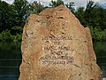
Memorial stone for the bridge building on September 25, 1799 on the Limmat near Dietikon

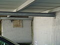
Information board for building bridges


On the basis of operational order No. 2 of October 4, 1939 (deployment north), the Swiss army occupied the Limmat position from Sargans to the Gempenplateau in order to be able to stop an attack from the north and a bypassing of the Maginot Line through Switzerland. The center section, the 25 km wide front between Zurich (Lake Zurich) and Brugg (mouth of the Limmat), was assigned to the 3rd Army Corps under Oberstkorpsommandant Rudolf Miescher . On this section of the front, the breakthrough of an enemy attack into the Reuss valley and thus direct access to the central position in the Gotthard area had to be prevented.
The Welsh 1st Division at Mutschellen and Heitersberg was used as reinforcement between the 6th Division (Uetliberg to Urdorfer Senke) and the 8th Division ( Rüsler to Windisch ) . Most of the troops of the 1st Division remained on the western border for reasons of neutrality and would not have been moved until an attack from the north. Their battle positions were therefore prepared by the ad hoc formation «Gruppe Dietikon». For ten months (October 1939 to August 1940) preparations were made to become the main battle line in a German attack.
Dietikon group
Commander and troops
The management of the Dietikon group was entrusted to veteran and experienced militia Colonel Alfred Roduner (1885–1969). The command of the Dietikon group was in the heavily guarded Hotel Krone, the command post of the 1st Division in Bremgarten.
500 men with 27 machine guns were provided to crew the core fortifications. In the Dietikon Army Group, around 60 different troop formations (infantry, mountain infantry, territorial troops, pontooners, catering and medical troops, sappers, auxiliary service (HD) construction groups, artillery) performed active service and helped build the fortress. Among them was the Edentaten company of the 3rd Army Corps, in which soldiers were brought together who had their teeth pulled in order to be exempted from active service. They received artificial teeth and the company was assigned a dentist. Her soldier's brand was the Kappeler milk soup , which you can eat without teeth.
A total of 5200 soldiers were quartered in Dietikon with a population of 6200 at the time. The lessons of individual school classes had to be held for nine months in other places such as the screed of a carpenter's workshop instead of in the central school building.
The local fire brigade had to watch one of the tasks, the landing of paratroopers and prevent. She had sealed envelopes with the names of members of the Fifth Column , whom she should have arrested immediately if the German invasion had occurred.
Army command and defense concept
The order for the defense of the Limmat position of the commander of the 3rd Army Corps on February 15, 1940 for the 1st Division was as follows:
- holds the section in the middle of the Limmat
- closes the Dietikon – Bremgarten road
- holds the heights of Kindhausen – Sennenberg
Corps commander Miescher was against defensive positions directly on the Limmat, as planned by General Henri Guisan , because these could be seen from the heights. They agreed on a compromise, which first provided for the fortification of the wooded hills south of the Limmat and later those directly on the Limmat, which was then no longer due to the redoubt.
In the run-up to the Uetliberg Fortress , the 6th Division, Zurich City Command and the Dietikon Group (1st Division) established bases in Altstetten (Dachsleren, Kappeli, Panama), Oberurdorf and Dietikon (Dietikon Fortress ) for anti-tank fighting and all-round defense . In the village core, the houses were converted into fireplaces, the spaces in between were connected by walls, concrete, iron posts and reinforced with barbed wire.
Behind these bases, an enemy breakthrough on the wooded hills with obstacles, iron barriers and tank ditches should be stopped.
The artillery was well camouflaged in the Ringlikon (Brand), Birmensdorf (Haslen, Maas, Ramerenwald, Risi, Egg, Schüren, Löffler), Bonstetten (Hörglen), Oberlunkhofen (Matteried) and Bremgarten (Hegnau) areas in a loose, chessboard-like form set up. The 18 batteries with a total of 72 pipes could reach Zurich, Wallisellen , Rümlang , Dielsdorf and the warehouses via the Urdorfer Senke and Waldegg . You were also responsible for artillery fire protection at the Limmat crossings from Wipkingen and Dietikon.

Uetliberg observation bunker

Artillery position Brand, Ringlikon-Uitikon

Artillery position Schüren, Birmensdorf


Evacuation of the civilian population
In December 1939 General Guisan gave the order to prepare the evacuation of the population (around 400,000 people) along the Limmat position in the event of an attack from the north. In Dietikon, an evacuation service was set up by the local council, which had to prepare the evacuation of half of the approximately 6000 inhabitants at the time. Cows and cattle would also have been evacuated as living provisions. The Aargau population of the Limmat position should have marched into the cantons of Friborg and Vaud. The withdrawal of the army into the Reduit made evacuation pointless because there was no food or space there.
Fortifications
In addition to the core fortification, Dietikon was surrounded by two barriers in the west and east, each of which led from the wooded hills over the valley floor to the Limmat. The entire forest area was declared a restricted military area. Roads and paths have been blocked. In 1939, the Dietikon group built tank barriers as external blocking positions, on which the weapons from around 24 bunkers were aimed. In the center of Dietikon, a fortress with bunkers and a concrete ring wall of 300 × 150 m was built. During wartime, the central school building and church square comprised a total of seven bunkers and 900 meters of fortress wall.
The important base was inspected twice by General Guisan in 1940. The central school building in the center of the concrete ring wall was surrounded by defensive walls and bunkers and served as a mobilization area. Soldiers were quartered there and changing of the guard and main reading took place on the playground . With the withdrawal to the Reduit , the construction work was stopped or greatly reduced.
In 1944, due to a reassessment of the military situation southwest of the Limmat, the fortification was intensified again. Bunkers with anti-tank weapons, crew shelters and kilometers of cusp lines and infantry obstacles were built.
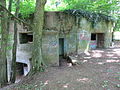
Core fastening
Two pieces of the core fortification are still preserved behind the central school building (with Berta corner bunker) and by the Catholic Church (with corner bunker). The top of the wall was reinforced with broken glass set in concrete. Bunkers were built at the corners of the wall. The soldiers' shelters were set up in reinforced cellars in the residential buildings within the core fortifications.
- Tank wall base Dietikon ⊙
- Corner bunker Berta A 5236, mobile Lmg ⊙
- Corner bunker east A 5237, mobile Lmg ⊙
- Corner bunker west ⊙

Overview of the core fastening

Corner bunker «Berta» behind the central school building A 5236

Fortress wall at the Catholic Church, corner bunker West with a bricked-up gap
Fortress wall at the Catholic Church, corner bunker east A 5237


Northwest Barrier
The 3.7 km north-west barrier with its five bunkers led from the Junkholz hill on the edge of the village of Spreitenbach via Niderfeld to the Limmat near Fahrweid.
The bunkers that still exist today were built in 1941:
- Infantry bunker “Unterdorf” A 5240 (courtyard with access to Gjuchstrasse; three heavy machine guns, three light machine guns and two tank cans, 23 man crew) ⊙
- Concrete sign for IK Junkholz A 5243, Spreitenbachstr. 35, Dietikon ⊙
- Anti-tank bunker “Gigenpeter” A 5244 (two heavy machine guns / two tank rifles, three light machine guns) ⊙
- Concrete sign for Ik Junkholz A 5245, Spreitenbach ⊙
- Concrete sign for Ik Junkholz A 5246, Spreitenbach ⊙
- Infantry bunker old target stand A 5247 Schürmatt Spreitenbach ⊙
- Mine throwing position Bergdietikon ⊙
- Kindhausen Nordende tank barrier ⊙
- Kindhausen forest barrier ⊙
The bunkers demolished today were built in May 1940:
- "Gas station" on the main road to Spreitenbach at the junction to Fahrweid
- "Reppischbrücke" (camouflaged as "wood storage"; three machine guns, one tank can)
- «Underpass» (camouflage "Tomb exhibition")
Concrete shield for infantry cannon (Ik) Junkholz, Spreitenbach
Ik-Schild Junkholz West A 5246 (Tarn Det.10 Gr.1)
"Gigenpeter" bunker
Bunker "Unterdorf"


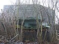
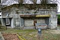
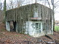
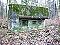
Southeast barrier
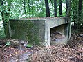
The 1.9 km long southeast barrier led from the Lindenbühl hill to the point on the Limmat, where the French bridged in 1799. It was flanked by 14 bunkers. The lock was partially completed in mid-1941. The infantry factory "Lindenbühl Ost" formed the southern end of the barrier. About 200 m below the Lindenbühl Ost infantry plant, a tank wall was built by HD soldiers. On the road towards Mutschellen are the remains of a tank barrier (hump line). In the Guggenbühlwald, six bunkers flanked the southeast barrier. A concrete hump line was built from the Guggenbühlwald to the Vogelau bunker near the Wolfsmatt school building. At its upper end is the A 5232 flanking bunker.
- Infantry factory "Lindenbühl Ost" A 5223, infantry cannon on field carriage, SMg, 4 LMg, 19 men ⊙
- Infantry bunker «Buchholz» A 5222, fortress Girhalden, three-story, machine gun (MG) stand ⊙
- Lindenbühl tank wall ⊙
- "Chicken coop" observation bunker (Pak) A 5224, a tank canister (TB) ⊙
- Anti-tank bunker A 5225, a TB, 2 Mg ⊙
- Infantry bunker A 5226, 1 light machine gun (Lmg) ⊙
- Infantry bunker A 5227, 1 Lmg ⊙
- Infantry bunker A 5228, 1 Lmg ⊙
- Infantry bunker A 5229, 1 Lmg ⊙
- Infantry bunker A 5230, 1 Lmg ⊙
- Infantry bunker A 5231, 1 Lmg ⊙
- Anti-tank bunker A 5232, 1 TB, 1 Mg ⊙
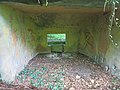
- Anti-tank bunker "Vogelau" A 5233, three-story 10m high, 5 SMg, 2 TB, 22 men ⊙
- Terrain tank obstacle (GPH) hump line Guggenbühl T 2577 ⊙
- A bunker with a light machine gun on the railway line was demolished during the four-track expansion.
- The "Schäflibach" bunker near the railway line was demolished in 1996.

"Buchholz" bunker
Bunker "Lindenbühl Ost"
"Chicken coop" observation bunker A 5224

Tank barrier Mutschellenstrasse

Bunker Guggenbühlwald A 5230

Cusp line Guggenbühl T 2577
"Vogelau" bunker A 5233
"Vogelau" bunker, access to the lower floors A 5233


Southwest barrier
- Shelter Hohnert Kiesgrube Süd A 5189 Guggenmattstrasse ⊙
- Shelter Hohnert Kiesgrube Nord A 5190 Guggenmattstrasse ⊙
- Shelter Honeret A 5191 Bremgartenstrasse ⊙
- Shelter Honeret A 5192 Bremgartenstrasse ⊙
- Mg bunker Honeret A 5193 Bremgartenstrasse ⊙
- Mg bunker Hohnertwald A 5194 (broken off) ⊙
- Shelter Honeret A 5195 Reppischhof ⊙
- Bunker infantry cannon 4.7cm A 5196 Fischerhölzli ⊙
- Shelter Holenstrasse A 5197 Fischerhölzli ⊙
- Shelter Holenstrasse A 5198 Fischerhölzlistrasse ⊙
- Bunker Ik-Kanone 4.7cm Unterreppischtal A 5199 Stigelmatt Urdorf ⊙
- Bunker Ik-Kanone 4.7cm Unterreppischtal A 5200 Oberächer Urdorf ⊙
- Shelter Unterreppischtal A 5201 Reppischtalstrasse Urdorf ⊙
- Atomic protection shelter ASU 24 F 20023 ⊙
- ASU 23 F 20024 ⊙
- ASU 25 F 20025 ⊙
- ASU 26 F 20026 ⊙
- ASU 35 F 20027 ⊙
- ASU 29 F 20030 ⊙
- ASU 30 F 20031 ⊙
today

After the end of the war, the fortifications in and around Dietikon began to be demolished, but this was more complex and expensive than expected due to the solid construction. The community received federal funding for the demolition of the wall behind the new central school building. Since the population was more interested in a new swimming pool, the money was used for this purpose and the city's concrete wall was preserved. The demolition of this rough concrete colossus of around 75 meters in length, 3 meters in height and 1.5 meters in thickness at the base was discussed again in 2001, when Dietikon announced a competition for the construction of two kindergartens at this point. The fact that the two kindergartens could even be built despite political headwinds was thanks to an architect's design that integrated the kindergartens into the wall in such a way that the entire length of the wall could be preserved.
In the Dietikon local museum, a room with a city model of the time and historical photographs of the fortress is dedicated.
Bremgarten-Hegnau artillery position
In the middle section of the Limmat position, civil construction companies erected permanent cannons from March to June 1940. In Bremgarten-Hegnau, two battery positions were created for field artillery department 1 (1st division), which were supposed to prevent enemy crossings across the Limmat. A third position (Bremgarten-Ripplisberg) was created on the southwestern outskirts of Bremgarten, which is no longer available today. The Bremgarten-Hegnau artillery position is a military-historical monument of national importance.
The two battery positions in Hegnau consisted of four gun positions each (with splinter protection against the top) and two crew quarters each. With a concrete platform for the gun wheels and incisions in the ceiling, the gun stands could be used for 7.5 cm field cannons (maximum evaluation 45 degrees) and for 12 cm field howitzers:
- Artillery positions Hegnau A 4179 ⊙ and A 4181 ⊙
- Shelter Hegnau A 4180 (for 4179 and 4181) ⊙
- Artillery positions Hegnau A 4183 ⊙ and A 4184 ⊙
- Shelter Hegnau A 4182 (for 4183 and 4184) ⊙
- Artillery positions Hegnau A 4186 ⊙ and A 4187 ⊙
- Hegnau A 4185 shelter (for 4186 and 4187) ⊙
- Artillery positions Hegnau 4189 ⊙ and A 4190 ⊙
- Shelter Hegnau A 4188 (for 4189 and 4190) ⊙

Gun base Hegnau for mobile 7.5 cm field cannon or 12 cm field howitzer

Gun stand Hegnau A 4183 with ammunition rack

Gun stand Hegnau A 4183 inside

Hegnau A 4182 shelter


literature
- Walter Lüem u. a .: The position of the Limmat in World War II , Baden-Verlag, Baden 1997, ISBN 3-85545-105-2 .
- Max Rudolf, Andreas Steigmeier : Guide to the Limmat position from the Second World War. Baden-Verlag, Baden 1998, ISBN 3-85545-114-1 .
- Military monuments in the canton of Zurich, inventory of combat and command structures. Ed. Federal Department of Defense, Civil Protection and Sport . Bern 2004.
- Silvio Keller, Maurice Lovisa, Patrick Geiger: Military-historical monuments in the canton of Aargau. DDPS 2006 (PDF; 7.9 MB).
- Urs Lengwiler, Verena Rothenbühler, Markus Stromer, Martin Lengwiler . Everyday life in the Dietikon Fortress. In: Dietikon - city air and village spirit . Chronos Verlag, Zurich 2003, ISBN 978-3-0340-0662-0 .
Web links
- Military monuments in the canton of Zurich, inventory of combat and command structures (PDF; 2.9 MB)
- Pictures of the Limmat position
- Aargauer Zeitung of August 1st, 2009: Swiss will to resist - demonstrated in Dietikon
- Limmattalerzeitung from May 11, 2014: When Dietikon was still a fortress against Hitler's Germany
- Limmattalerzeitung from June 12, 2014: Suddenly soldiers dominated the village of Dietikon
- Limmattalerzeitung from June 16, 2014: Military showpiece - Dietikon Fortress was built 75 years ago
- Limmatalerzeitung from August 30, 2014: Even General Guisan got an idea of the Dietikon fortress
- Bunker friends Switzerland: Dietikon facilities
Individual evidence
- ^ Karl Schori: The defensive position Uetliberg in World War II. Swiss Society for Military History Study Trips (GMS), April 2000
- ↑ «Wherever it is ordered to hold, every fighter, even if he is dependent on himself, makes it his conscience to fight in the place assigned to him. (...) As long as a man still has a cartridge or is still able to use his bare weapon, he will not surrender. " Army order from General Guisan dated May 15, 1940
- ↑ Walter Lüem include: The Limmat position in World War II . Baden-Verlag, Baden 1997
- ^ Nextroom / archithese 2006: Kindergartens Central I + II Dietikon
- ^ Stadtverein Dietikon: Dietikon in World War II. Permanent exhibition in the local museum
- ^ Silvio Keller, Maurice Lovisa, Patrick Geiger: Military historical monuments in the canton of Aargau. DDPS 2006
- ^ Oberland Fortress: Bremgarten artillery position
Coordinates: 47 ° 24 '8.4 " N , 8 ° 24' 10.2" E ; CH1903: six hundred seventy-two thousand seven hundred and eighty-three / 250616