
Windisch AG
| AG is the abbreviation for the canton of Aargau in Switzerland and is used to avoid confusion with other entries of the name Windisch . |
| Windisch | |
|---|---|
 |
|
| State : |
|
| Canton : |
|
| District : | Brugg |
| BFS no. : | 4123 |
| Postal code : | 5210 |
| Coordinates : | 658 758 / 258 984 |
| Height : | 361 m above sea level M. |
| Height range : | 327–468 m above sea level M. |
| Area : | 4.91 km² |
| Residents: | 7607 (December 31, 2019) |
| Population density : | 1549 inhabitants per km² |
|
Proportion of foreigners : (residents without citizenship ) |
28.9% (December 31, 2019) |
| Website: | www.windisch.ch |
 Windisch |
|
| Location of the municipality | |
  |
|
Windisch ( Swiss German : ˈʋɪnˌdiʃ ) is a municipality in the Swiss canton of Aargau . It belongs to the district of Brugg and is located immediately south of the district capital Brugg , between the Aare in the north and the Reuss in the east (and thus in the area of Switzerland's moated castle ). Windisch is known as the location of the Roman legionary camp Vindonissa , the Königsfelden monastery and the Northwestern Switzerland University of Applied Sciences .
geography
The community lies between the Aare in the north and the Reuss in the east. The area of the municipality is 491 hectares , of which 122 hectares are forested and 233 hectares are built over. The settlement landscape of Windisch consists of several districts, which in the 19th and early 20th centuries grew together to form a single village and by the end of the 20th century with the neighboring towns of Brugg and Hausen they grew together to form a closed agglomeration.
The Kirchweiler with the old parish church is located on the narrow spur of the hill above a bend in the Reuss, around two kilometers from its confluence with the Aare . On the peninsula east of it lies the heap-shaped part of the village Unterwindisch at the old ferry point over the Reuss, around forty meters below . With an approximately 1,600 meter long factory canal to the left of the Reuss, water power was made available for the large Kunz spinning mill around 1830 , from whose factory power station the Windisch power station later emerged. To the west of the parish church, the plain with the upper village, the district of Oberburg and the Königsfelden monastery extends on a high terrace created during the Ice Age. The freshwater stream crossed by Birrfeld Coming the valley at Hausen and then the Windischer Weiermatt and leaves the municipality of Windisch in the tunnel under the track area of the station; in Brugg it flows into the Aar.
From the southeast, the Reuss flows from Mellingen through a gorge around 30 meters deep, the western flank of which is about two kilometers, from the Chrüzhalde to the Dägerli area, in the Windisch area. An island in the river and sections of the natural alluvial forest belong to Windisch. When it comes to cargo, the Reuss flows into the narrow plain at the road bridge on Hauptstrasse 3 .
The Geissenschachen island is located in the Aare and is used by the Swiss Army as a barracks area.
In the southeast, the area from Windisch near Wiedlung Lindhof extends to the wooded hills west of the Reuss. The highest point is the summit of the Hölzli at 468 meters, the lowest is at the confluence of the Aare and Reuss rivers at 328 meters.
The neighboring communities of Windisch are Brugg in the west and north, Gibstorf and Birmenstorf in the east, Mülligen in the southeast and Hausen in the south.
history
Place name
The place name is first found 104/109 as Vindonissa in Tacitus ' historical work Historiae . The Germanized form can be seen as Vindisso and Windesch for the first time in a source from 1101/1150 (copy from the 14th century); de Windischo was named from 1248 ( -o is the Latin ablative ending depending on the preposition de “from”), in the Habsburg Urbar from 1303/1308 the form ze Windische (with the German dative ending). The name is either formed from the Celtic personal name Vindos or the Celtic generic word * uindo- "white", both supplemented by the suffix -is (s) a, and thus means either "place of Vindos" or "Weissbach". Since the male personal name is well attested, name research tends towards the former explanation.
Celtic and Roman times

In Celtic times one was on the headland between the Aare and Reuss Oppidum of the Helvetii , from 2003 next to the old village school house a fortress with a moat, mound and tree strong wooden posts was discovered. Around 15 BC A small Roman military station was built on the plain to the west of it. Thirty years later it was expanded to become the Vindonissa legionary camp . The camp, of which some restored ruins can be visited today, was the headquarters of three different legions from AD 14 to AD 101, the Legio XIII Gemina , the Legio XXI Rapax and the Legio XI Claudia . For a long time without the presence of Roman troops, Vindonissa developed into a civil village settlement. In the late 3rd century a fort was built again, which the Romans finally gave up in 401. One of the two largely underground water pipes built for the legionary camp is the only still functioning and water-bearing Roman pipe in Switzerland. The rich archaeological finds from the excavations in the Roman settlement are mostly in the Vindonissa Museum in Brugg.
Around 293 the Roman military leader Constantius Chlorus defeated an Alemannic army near Vindonissa.
middle Ages


A bishopric in Vindonissa and a mint are documented for the 6th century . The bishopric had existed since the year 517 at the latest and according to a building inscription in Vindonissa it was moved to Constance in 590 . The bishops Bubulcus (517-534), Cromatius (534-552) and Ursinus (around 590) are documented by name. The village settlements that arose in the ruins of the Roman camp belonged to the Eigenamt , the oldest possession of the Habsburgs in Aargau, whose headquarters are about two kilometers southwest of Windisch on the Wülpelsberg , even before the year 1000 .
On May 1, 1308, King Albrecht I was murdered by his nephew Duke Johann von Schwaben not far from the Reuss crossing . In memory of the ruler, the king's widow Elisabeth von Görz-Tirol founded a monastery in the area of the former fort, which she called Königsfelden . The double monastery with Poor Clares and Franciscans experienced under Elisabeth's daughter Agnes of Hungary , the widow of the Hungarian King Andreas III. , its prime. In 1397 the Habsburgs gave the monastery its own office with all associated rights of rule. After the conquest of Aargau by the Confederates in 1415, the city of Bern took over rule; the Eigenamt was now part of the subject areas in the Bernese Aargau .
Modern times
In 1528 the Bernese introduced the Reformation and dissolved the Königsfelden monastery. They converted their own office to the Landvogtei Königsfelden and took over all legal titles in the region; a court master was in charge of the administration of the former monastery property. Sixty percent of the population fell victim to a plague epidemic in 1667 . In March 1798 the French took Switzerland, ousted the «Gracious Lords» of Bern and proclaimed the Helvetic Republic . Since then, Windisch has belonged to the canton of Aargau. In 1799, the French troops built a bridge over the Reuss, which replaced the ferry on the Zurich - Basel road . In 1804 the canton of Aargau took over the former Königsfelden monastery, and since 1868 the new building complex to the west of the monastery has served as a psychiatric clinic .
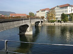
In 1828, the “Spinner King” Heinrich Kunz built the large Kunz cotton spinning mill in Unterwindisch with an extensive dam in the Reuss, the water power of which he was able to use thanks to a water rights concession from the Canton of Aargau. This marked the beginning of the industrial age in Windisch. On May 15, 1858, the railway line was continued from Baden to Windisch and Brugg. East of Windisch it leads over the Reuss Bridge . Although the station was on Windischer territory, it was named after the city of Brugg . Despite the early connection to the railway network, the community was financially poor. In 1863 she therefore sold an area of 45 hectares to Brugg. Today the train station, a shopping center and several industrial companies are located there.
Windisch was able to make up for this loss of importance by building the technical college (from which the University of Applied Sciences Northwestern Switzerland later emerged). With advancing industrialization and immigration, housing developments emerged on the open spaces between the individual districts. In 1986 the 2000th anniversary of Vindonissa / Windisch was celebrated. Between 1980 and 2000 the population decreased by over 12%, but has since stabilized again. Because the settlement areas of Brugg and Windisch have grown together completely and because the two communities have to work more closely together because of the extensive “Vision Mitte” project (expansion of the university of applied sciences), the call for a community merger was loud. In May 2006, both municipal parliaments clearly approved a popular initiative that demanded the start of negotiations in this regard. But a referendum was held against this decision in Brugg. The referendum took place on September 24, 2006; the initiative was clearly rejected with a majority of 63%.
Attractions


Ruins of the legionary camp Vindonissa , the Windischer Amphitheater west of it and two water pipes from the 1st century (one of which is partly still in use today) have been preserved. Traces of various sanctuaries, a port, four cemeteries, a mansio and a large rubbish hill are known from Roman times . Time and again, construction workers come across Roman finds in the village. The Vindonissa Museum in Brugg shows many objects from the numerous excavations in Windisch. The Vindonissa Legionnaires' Path conveys everyday life in a Roman legionnaire's camp.
The most important medieval building is the Königsfelden monastery , which was built in 1308 on the initiative of the Habsburgs. Despite the abolition of the monastery during the Reformation and extensive demolition work in the 19th century, the remaining buildings, the monastery park and above all the monastery church with its art-historically valuable glass paintings from the 14th century are still worth seeing.
The former bishopric of Vindonissa has not been preserved. At the turn of the 14th to the 15th century, today's Reformed Church was built , with various parts coming from a previous building. The local museum Schürhof shows home decor and utensils from the Middle Ages that were used in the household, in agriculture and in trade.
coat of arms
The blazon of the municipal coat of arms reads: "In yellow on five green mountains, black castle, accompanied on the left by a soaring red lion." The coat of arms motif first appeared on a pane of glass in 1872; the background of the shield was red, however, and the lion yellow. In 1950 the colors were swapped, and since then the coat of arms has conformed to the heraldic color rules. The castle is reminiscent of the Roman legionary camp Vindonissa, the lion of the rule of the Habsburgs. The Fünfberg im Schildfuss points to the elevated position above the valleys of the Aare and Reuss.
population
The population developed as follows:
| year | 1736 | 1815 | 1850 | 1900 | 1930 | 1950 | 1960 | 1970 | 1980 | 1990 | 2000 | 2010 |
| Residents | 402 | 661 | 1287 | 2389 | 3585 | 4363 | 5377 | 7444 | 7598 | 6915 | 6650 | 6598 |
On December 31, 2019, 7607 people lived in Windisch, the proportion of foreigners was 28.9%. In the 2015 census, 27.9% described themselves as Roman Catholic and 25.2% as Reformed ; 46.9% were non-denominational or of other faiths. In the 2000 census, 80.6% said their main language was German , 4.9% Italian , 3.2% Serbo-Croatian , 2.9% Turkish , 2.2% Albanian , 0.9% Portuguese and 0.8% Spanish .
Politics and law
legislative branch
Instead of a community assembly that is common in smaller communities, the community parliament elected by the Windischer voters, the residents' council , has represented the concerns of the population since 1974 . It consists of 40 members who are each elected for four years by proportional representation. He is responsible for approving the tax rate , the budget, the annual accounts, the annual report and the loans. It also issues regulations, controls the conduct of office of the executive and decides on naturalizations . The residents' councils can submit parliamentary proposals ( motion , postulate , small questions ).
The graphic on the right shows the distribution of seats after the election on September 24, 2017. In the last five elections, the parties achieved the following number of seats:
| Political party | 2001 | 2005 | 2009 | 2013 | 2017 |
|---|---|---|---|---|---|
| SP | 11 | 13 | 14th | 14th | 18th |
| SVP | 10 | 10 | 11 | 9 | 7th |
| FDP | 8th | 7th | 6th | 8th | 7th |
| CVP | 6th | 6th | 5 | 5 | 5 |
| EPP | 5 | 4th | 4th | 4th | 3 |
Various elements of direct democracy can also be found at the level of the resident community . The population is entitled to optional and compulsory referendums as well as the popular initiative .
executive
The executing authority is the five-member municipal council . He is elected by the people for four years in a majority process . The municipal council leads and represents the community of residents. To this end, it implements the resolutions of the residents' council and the tasks assigned to it by the canton.
Judiciary
The Brugg District Court is the first instance responsible for legal disputes . Windisch belongs to the Friedensrichterkreis VIII (Brugg).
economy

According to the corporate structure statistics (STATENT) collected in 2015, there are around 4,700 jobs in Windisch, of which 1% in agriculture, 16% in industry and 83% in the service sector. Windisch is the seat of the tourism and transport company Knecht Holding , and itemis AG also has a branch here. Many workers are commuters and work in Brugg or in the Baden region .
traffic
Windisch is on important national transport lines. The national main road 3 , coming from Brugg, passes the village and crosses the Reuss to the east. Kantonsstrasse 280 leads through the Birrfeld towards Wohlen , Kantonsstrasse 296 west of the Reuss to Mellingen . The Birrfeld connection to the A3 motorway is just under three kilometers south of Windisch.
The new “Southwest bypass Brugg” (under construction from 2019 to 2021) connects the canton roads K112 (Aarauerstrasse) in Brugg and K 118 near Hausen and crosses the Weiermatt von Windisch area.
The Brugg railway station of the SBB is up to the municipal boundary; it is an important express train stop for trains to Basel , Bern and Zurich as well as the terminus of the S12 line of the Zurich S-Bahn . On weekends there is a night bus from Brugg via Windisch and Birr to Habsburg and Mülligen . The railway line to Baden crosses the Reuss northeast of the Rüssschache from Windisch on the SBB Reussbrücke Turgi . The connecting line from Villnachern west of Brugg station to Hausen has been in operation since 1969; it is primarily used for international freight traffic through the Gotthard .
Postbus lines lead from Brugg train station to Birr , Birrhard , Scherz , Mellingen, Heitersberg , Thalheim , Mönthal , Frick , Bad Zurzach , Linn , Döttingen , Schinznach-Bad and Unterwindisch.
Veloroute 5 ( Mittelland Route (Switzerland) Mittelland Route ) in the SwitzerlandMobility network runs through Windisch .
Two supraregional hiking trails cross the municipality: the Jurahöhenweg (National Route 5) and the hiking trail 42 “Aarauer Weg”, which leads in six stages from Frick to Muri.
In Windisch, SwitzerlandMobility also lists skating route 3, several marked mountain bike trails and canoeing routes 1 on the Aare and 90 on the Reuss, which ends at Unterwindisch.
education
All elementary school levels are offered in five school buildings ( primary school , secondary school , secondary school , district school ). The closest grammar schools are the Baden Cantonal School and the Wettingen Cantonal School .
In 1997, the technical department of the Aargau University of Applied Sciences was created from the Brugg-Windisch Technical College (HTL) (from 2006 Northwestern Switzerland University of Applied Sciences ). Since 2013, the Brugg-Windisch campus has been comprised of the FHNW University of Education, the FHNW University of Applied Sciences, the FHNW School of Business, the campus library and the board of directors and the FHNW services. The offer at the Brugg-Windisch location comprises 14 bachelor and master courses for 3,000 students. Around 1000 employees work on the Brugg-Windisch campus.
The industrial culture path Limmat-Wasserschloss provides information about the technical history of the region and the legionnaires' path Vindonissa about life in a Roman legionnaire's camp. The SBB historic foundation in Windisch documents the history of the railways in Switzerland.
Infrastructure
Around 1967, the Brugg Region Wastewater Association built the Brugg-Birrfeld sewage treatment plant - “ARA Wasserschloss” - in Windisch's Aareschachen. In order to meet the increased requirements, the system was expanded to include a biofiltration section in 2016 . The groundbreaking for this project was on June 19, 2014.
Personalities
- Rita Ernst (* 1956), artist
- Arthur Kielholz (1879–1962), clinic director
- Stephan Leimgruber (* 1948), theologian
- Ernst Linck (1874–1935), painter
- Urs Odermatt (* 1955), director
- Raimondo Ponte (* 1955), football player and coach
- Andreas Pritzker (* 1945), physicist and writer
- Hans Schatzmann (1849–1923), Federal Chancellor
- Agnes of Hungary (around 1281–1364), Queen of Hungary, founder of the Königsfelden Monastery
gallery

Reuss weir at the former Heinrich Kunz cotton spinning mill
Heinrich Kunz cotton spinning mill

Bossartschür: former restaurant from 1801

University of Applied Sciences Northwestern Switzerland (formerly Brugg-Windisch Technical Center)

Lindhof barn


.jpg)


literature
- Max Baumann: Windisch. In: Historical Lexicon of Switzerland .
- Max Baumann: The story of Windisch. From the Middle Ages to the Modern Age. Windisch 1983.
- Michael Stettler , Emil Maurer : The art monuments of the canton of Aargau . In: Society for Swiss Art History (Ed.): Art Monuments of Switzerland . Volume II: The districts of Lenzburg and Brugg. Birkhäuser Verlag, Basel 1953, DNB 750561750 .
Web links
Individual evidence
- ↑ Cantonal population statistics 2019. Department of Finance and Resources, Statistics Aargau, March 30, 2020, accessed on April 2, 2019 .
- ↑ Cantonal population statistics 2019. Department of Finance and Resources, Statistics Aargau, March 30, 2020, accessed on April 2, 2019 .
- ↑ a b Beat Zehnder: The community names of the canton of Aargau . In: Historical Society of the Canton of Aargau (Ed.): Argovia . tape 100 . Verlag Sauerländer, Aarau 1991, ISBN 3-7941-3122-3 , p. 467-470 .
- ↑ Standard area statistics - municipalities according to 4 main areas. Federal Statistical Office , November 26, 2018, accessed on June 11, 2019 .
- ^ National map of Switzerland, sheet 1070, Swisstopo.
- ↑ Lexicon of Swiss municipality names . Edited by the Center de Dialectologie at the University of Neuchâtel under the direction of Andres Kristol. Frauenfeld / Lausanne 2005, p. 970 f.
- ^ Franz B. Maier-Osterwalder: The water-bearing Roman aqueduct from Hausen to Vindonissa. In: Archeology of Switzerland , Vol. 17, 1994, No. 4, pp. 140–152. ( Online )
- ^ Emil Egli: The Christian inscriptions of Switzerland from 4. – 9. Century. Zurich 1895, p. 53.
- ↑ Marcel Beck: Königsfelden. History, buildings, glass paintings, art treasures. Olten 1970.
- ^ A merger referendum is available, Aargauer Zeitung, June 14, 2006
- ↑ merger with Windisch bachab sent Aargauer Zeitung, September 25 of 2006.
- ↑ Marcel Beck: Königsfelden. History, buildings, glass paintings, art treasures. Olten 1970.
- ^ Museum Schürhof
- ^ Joseph Galliker, Marcel Giger: Municipal coat of arms of the Canton of Aargau . Lehrmittelverlag des Kantons Aargau, book 2004, ISBN 3-906738-07-8 , p. 316 .
- ↑ Population development in the municipalities of the Canton of Aargau since 1850. (Excel) In: Eidg. Volkszählung 2000. Statistics Aargau, 2001, archived from the original on October 8, 2018 ; accessed on June 11, 2019 .
- ↑ Resident population by religious affiliation, 2015. (Excel) In: Population and Households, Community Tables 2015. Statistics Aargau, accessed on June 11, 2019 .
- ↑ Swiss Federal Census 2000: Economic resident population by main language as well as by districts and municipalities. (Excel) Statistics Aargau, archived from the original on August 10, 2018 ; accessed on June 11, 2019 .
- ↑ circles of justice of the peace. Canton of Aargau, accessed on June 17, 2019 .
- ↑ Statistics of the corporate structure (STATENT). (Excel, 157 kB) Statistics Aargau, 2016, accessed on June 11, 2019 .
- ↑ Brugg - Southwest Bypass at www.ag.ch, accessed on June 26, 2020.
- ↑ Mittelland route on veloland.ch
- ↑ FHNW - University of Applied Sciences Northwestern Switzerland. In: University of Applied Sciences Northwestern Switzerland. Retrieved July 30, 2016 .
- ↑ Brugg sewage treatment plant
- ↑ Rehabilitation measures of the ARA Wasserschloss - a permanent task ARA Wasserschloss wastewater association, accessed on June 29, 2020.
Auenstein | Birr | Birrhard | Brugg | Bözberg | Bözen | Effingen | Elfingen | Habsburg | Hausen | Lupfig | Mandach | Mönthal | Garbage | Remigen | Riniken | Rüfenach | Schinznach | Thalheim | Veltheim | Villigen | Villnachern | Windisch
Former communities:
Altenburg |
Gallenkirch |
Hottwil |
Lauffohr |
Linn |
Oberbözberg |
Upper flax |
Pure |
Joke |
Schinznach-Bad |
Schinznach village |
Stilli |
Umiken |
Untersözberg
Canton of Aargau | Districts of the Canton of Aargau | Municipalities in the Canton of Aargau