Riniken
| Riniken | |
|---|---|
| State : |
|
| Canton : |
|
| District : | Brugg |
| BFS no. : | 4111 |
| Postal code : | 5223 |
| Coordinates : | 656543 / 260 622 |
| Height : | 392 m above sea level M. |
| Height range : | 369-516 m above sea level M. |
| Area : | 4.76 km² |
| Residents: | 1458 (December 31, 2019) |
| Population density : | 306 inhabitants per km² |
|
Proportion of foreigners : (residents without citizenship ) |
17.9% (December 31, 2019) |
| Website: | www.riniken.ch |
|
Riniken |
|
| Location of the municipality | |
Riniken ( Swiss German : ˈriːnikχə ) is a municipality in the Swiss canton of Aargau . It belongs to the Brugg district and is located two kilometers northwest of the district capital.
geography
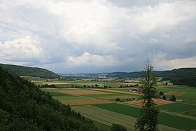
The village lies in a trough-like valley between the Bruggerberg ( 516 m above sea level ) in the east and the Ebni ( 514 m above sea level ) in the west, two wooded hills on the edge of the Table Jura . The slope of the Bruggerberg is flat and sloping evenly. The Iberg ( 485 m above sea level ), a foothill of the Ebni, narrows to the north to a 250 meter wide and more than 100 meter high rock bar that drops steeply on three sides. There is the castle ruins of the same name . Ebni and Iberg separate the village from the elongated Ital, in which the Reinerbach rises. The extensive Rüfenach plain extends to the northeast. About one kilometer south of Riniken is the district of Tiefgrueb ( 390 m above sea level ), which has merged with Umiken .
The area of the municipality is 476 hectares , of which 271 hectares are forested and 60 hectares are built over. The highest point is at 514 meters on the Ebni, the lowest at 373 meters at the northern foot of the Bruggerberg. Neighboring communities are Remigen in the north, Rüfenach in the east, Brugg in the south, and Bözberg in the northwest.
history
Finds of brick stamps of the Legio XXI Rapax and a ceramic fragment suggest that the Romans built a watchtower on the Iberg. Immigrant Alemanni founded the village in the 6th century. Rinichon was first mentioned in a document in 1253 when the Habsburgs transferred land in this settlement to the Wettingen monastery . The place name comes from the Old High German Rininghofun and means "at the farms of the Rino clan".
In the 13th century, the Habsburgs combined their sovereign rights west and north of Brugg in the Bözberg court. In addition to Riniken, this also included Oberbözberg , Unterbözberg , Lauffohr , Linn , Mönthal , Rein , Remigen , Rüfenach , Stilli and Villigen . Already in the second half of the 11th century, a lower noble family had Iberg Castle built in the service of the Habsburgs . The court changed hands several times from 1348 onwards by pledging and in 1377 it finally came under the rule of Schenkenberg . Most of the property belonged to the Königsfelden monastery in Windisch .
The city of Bern occupied the Schenkenberg rule militarily in 1460 and added it to the other subject areas in the Bernese Aargau . In 1528 the Bernese introduced the Reformation . In 1566 the judicial district of Bözberg was divided, whereupon the village was administered from Stilli . In March 1798 the French took Switzerland, ousted the «Gracious Lords» of Bern and proclaimed the Helvetic Republic . Riniken has been part of the canton of Aargau since then. Riniken remained a small, modest farming village until the middle of the 20th century. Then there was a lot of building activity and the village turned into a residential community. Between 1960 and 1990 the population more than quadrupled and has leveled off at around 1,400 in recent years.
Attractions
In the second half of the 11th century, Iberg Castle was built on the hill of the same name above the plain and was inhabited by ministerials of the Habsburgs. In the late Middle Ages, the 75 meter long complex fell into ruin; only part of the curtain wall is left. Riniken belongs together with Villnachern to the parish Umiken . Since 1978 Riniken has had its own church for the first time with the Lee Center; the modern building is used by both Catholics and Reformed people.
coat of arms
The blazon of the municipal coat of arms reads: "In yellow on a green three-mountain green fir with a brown trunk." This coat of arms appears for the first time on the municipal seal from 1872. Until 1953 the color of the shield ground was white instead of yellow and was changed to avoid confusion with similar municipal coats of arms. The local council rejected the proposal to change the unheraldic brown of the tree trunk in 2002.
population
The population developed as follows:
| year | 1764 | 1850 | 1900 | 1930 | 1950 | 1960 | 1970 | 1980 | 1990 | 2000 | 2010 |
| Residents | 213 | 338 | 291 | 304 | 300 | 352 | 947 | 1271 | 1420 | 1369 | 1454 |
On December 31, 2019, 1458 people lived in Riniken, the proportion of foreigners was 17.9%. In the 2015 census, 38.5% described themselves as Reformed and 27.5% as Roman Catholic ; 34.0% were non-denominational or of other faiths. In the 2000 census, 88.5% stated German as their main language, 2.3% Albanian , 1.5% each Italian and Turkish , 1.2% each French and Serbo-Croatian and 1.0% Portuguese .
Politics and law
The assembly of those entitled to vote, the municipal assembly , exercises legislative power. The executing authority is the five-member municipal council . He is elected by the people in the majority procedure, his term of office is four years. The parish council leads and represents the parish. To this end, it implements the resolutions of the municipal assembly and the tasks assigned to it by the canton. The Brugg District Court is the first instance responsible for legal disputes . Riniken belongs to the Friedensrichterkreis VIII (Brugg).
economy
According to the corporate structure statistics (STATENT) collected in 2015, there are around 290 jobs in Riniken, 9% of them in agriculture, 12% in industry and 79% in the service sector. Most of the employed are commuters and work in and around Brugg .
traffic
Riniken is located on Kantonsstrasse 455, which branches off in Umiken from Hauptstrasse 3 ( Basel - Zurich ) over the Bözbergpass and leads in the direction of Remigen . The village is connected to the public transport network by the Postbus line from Brugg train station to Laufenburg . On weekends there is a night bus from Brugg via Villigen and Remigen to Riniken.
education
Riniken has a kindergarten and a school house where the primary school is taught. All upper levels ( Realschule , Secondary School and District School ) can be attended in Brugg . The closest grammar schools are the Baden Cantonal School and the Wettingen Cantonal School .
Personalities
- Roland Salm (* 1950), cyclist
literature
- Felix Müller: Riniken. In: Historical Lexicon of Switzerland .
- Michael Stettler , Emil Maurer : The art monuments of the canton of Aargau . Ed .: Society for Swiss Art History . Volume II: The districts of Lenzburg and Brugg. Birkhäuser Verlag, Basel 1953, DNB 750561750 .
Web links
Individual evidence
- ↑ Cantonal population statistics 2019. Department of Finance and Resources, Statistics Aargau, March 30, 2020, accessed on April 2, 2019 .
- ↑ Cantonal population statistics 2019. Department of Finance and Resources, Statistics Aargau, March 30, 2020, accessed on April 2, 2019 .
- ↑ a b Beat Zehnder: The community names of the canton of Aargau . In: Historical Society of the Canton of Aargau (Ed.): Argovia . tape 100 . Verlag Sauerländer, Aarau 1991, ISBN 3-7941-3122-3 , p. 356 .
- ^ National map of Switzerland, sheet 1069, Swisstopo.
- ↑ Standard area statistics - municipalities according to 4 main areas. Federal Statistical Office , November 26, 2018, accessed on June 9, 2019 .
- ^ Martin Hartmann, Hans Weber: The Romans in Aargau . Verlag Sauerländer, Aarau 1985, ISBN 3-7941-2539-8 , p. 195 .
- ^ Joseph Galliker, Marcel Giger: Municipal coat of arms of the Canton of Aargau . Lehrmittelverlag des Kantons Aargau, book 2004, ISBN 3-906738-07-8 , p. 254 .
- ↑ Population development in the municipalities of the Canton of Aargau since 1850. (Excel) In: Eidg. Volkszählung 2000. Statistics Aargau, 2001, archived from the original on October 8, 2018 ; accessed on June 9, 2019 .
- ↑ Resident population by religious affiliation, 2015. (Excel) In: Population and Households, Community Tables 2015. Statistics Aargau, accessed on June 9, 2019 .
- ↑ Swiss Federal Census 2000: Economic resident population by main language as well as by districts and municipalities. (Excel) Statistics Aargau, archived from the original on August 10, 2018 ; accessed on June 9, 2019 .
- ↑ circles of justice of the peace. Canton of Aargau, accessed on June 18, 2019 .
- ↑ Statistics of the corporate structure (STATENT). (Excel, 157 kB) Statistics Aargau, 2016, accessed on June 9, 2019 .


