
Umiken
| Umiken | ||
|---|---|---|
 |
||
| State : |
|
|
| Canton : |
|
|
| District : | Brugg | |
| Residential municipality : | Brugg | |
| Postal code : | 5222 | |
| former BFS no. : | 4118 | |
| Coordinates : | 656 676 / 259402 | |
| Height : | 358 m above sea level M. | |
| Residents: | 1069 (December 31, 2009) | |
|
Proportion of foreigners : (residents without citizenship ) |
17.7% (Dec 31, 2009) | |
| map | ||
|
||

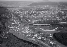
Umiken ( Swiss German : ˈʊ.mɪ.kχə ) is a village in the area of the city of Brugg in the Swiss canton of Aargau . The place north of the Aare was an independent municipality in the Brugg district until the end of 2009 and, with an area of 80 hectares, was the second smallest municipality in the canton at the time of the merger.
geography
The village lies on a steep southern slope at the transition between Bözberg and Bruggerberg . The settlement is largely terraced and has grown together completely with Brugg and the Tiefgrueb district, which belongs to Riniken . The Aare forms a natural border in the southeast. South of the village is the northern tip of the four-kilometer-long Schacheninsel, which was created by the construction of the power station and divides the Aare into two branches of the river.
The area of the former municipality was 80 hectares . Its highest point was at 434 meters on the Loohölzli, a small hill in the west, the lowest point at 335 meters on the banks of the Aare. Neighboring communities were Riniken in the north, Brugg in the east, Villnachern in the south-west and Unterbözberg in the north-west.
history

In the late 6th century Alemannic immigrants founded the Umminghofun settlement , which means "at the courts of the Ummo clan" in Old High German . Juomenkon was first mentioned in a document in 1254, when the municipality of Leuggern was given a vineyard on the road to Brugg ; The current spelling has been used since 1306. In the Middle Ages exercised Habsburg , the court rights from Umiken was the rule Schenkenberg . The lower jurisdiction and the right of patronage over the church belonged first to the Hallwylers , later to the lords of Reinach . In 1398 they sold their rights to the Johanniter in Klingnau .
Bern occupied the rule militarily in 1460 and added it as a new bailiff to the other subject areas in the Bernese Aargau . Umiken formed its own judicial district within the Landvogtei. In 1528 the Bernese introduced the Reformation . A curiosity was that the Catholic Order of St. John continued to remain the lord of interest and was even able to propose the Reformed pastor, who then had to be confirmed by Bern. In March 1798 the French took Switzerland, ousted the «Gracious Lords» of Bern and proclaimed the Helvetic Republic . Umiken has been part of the canton of Aargau since then.
In 1827 Umiken ceded the area around the Goppenbrunnenmühle to the city of Brugg. Until the beginning of the 20th century, Umiken was an agricultural community, with viticulture playing an important role. But since then the village has developed into a residential community on the outskirts of Brugg and agriculture has been almost completely displaced. Within a century the population increased almost fivefold. On June 27, 2008, the community assembly approved a contract regulating the merger of Umiken with Brugg. This decision was confirmed in the vote on September 28, 2008 with 330 to 55 votes (85.7% yes-vote). The merger took place on January 1, 2010.
Attractions


The Reformed Church was once dedicated to Saint Mauritius and was first mentioned in 1254. The masonry of the nave is in Romanesque and Gothic styles. The church tower was replaced by a new building after 1488, and the choir was built in 1521. The terrace settlement Mühlehalde , built between 1963 and 1971, was regarded as a highly regarded project for new forms of living during its creation.
coat of arms
The blazon of the former municipality and today's district coat of arms reads: "Divided by red with a growing yellow lion and by yellow with a stalked red clover." The earliest known depiction dates from 1788 on a stone tablet that was attached to the former tithe barn. In 1947 the local council ordered a graphic revision of the representation.
population
The population developed as follows:
| year | 1764 | 1831 | 1900 | 1930 | 1950 | 1960 | 1970 | 1980 | 1990 | 2000 |
| Residents | 143 | 218 | 234 | 434 | 467 | 648 | 868 | 886 | 849 | 999 |
On December 31, 2008, 1074 people lived in Umiken, the proportion of foreigners was 16.7%. In the 2000 census, 51.6% described themselves as Reformed and 28.6% as Roman Catholic ; 19.8% were non-denominational or of other faiths. 94.3% stated German as their main language, 2.1% Italian , 0.8% Serbo-Croatian and 0.7% French .
traffic
The main road 3 leads through Umiken over the Bözbergpass towards Basel . The village is connected to the public transport network by four post bus lines. These lead from Brugg train station to Frick , Laufenburg , Linn and Thalheim . On weekends there is a night bus from Brugg via Umiken, Schinznach-Bad and Veltheim to Thalheim.
literature
- Felix Müller: Umiken. In: Historical Lexicon of Switzerland .
- Michael Stettler , Emil Maurer : The art monuments of the canton of Aargau . In: Society for Swiss Art History (Ed.): Art Monuments of Switzerland . Volume II: The districts of Lenzburg and Brugg. Birkhäuser Verlag, Basel 1953, DNB 750561750 .
Web links
Individual evidence
- ↑ a b Beat Zehnder: The community names of the canton of Aargau . In: Historical Society of the Canton of Aargau (Ed.): Argovia . tape 100 . Verlag Sauerländer, Aarau 1991, ISBN 3-7941-3122-3 , p. 432-433 .
- ^ National map of Switzerland, sheet 1070, Swisstopo.
- ↑ Aargauer Zeitung : The merger is now nailed. September 28, 2009.
- ^ Joseph Galliker, Marcel Giger: Municipal coat of arms of the canton of Aargau . Lehrmittelverlag des Kantons Aargau, book 2004, ISBN 3-906738-07-8 , p. 296 .
- ↑ Population development in the municipalities of the Canton of Aargau since 1850. (Excel) In: Eidg. Volkszählung 2000. Statistics Aargau, 2001, archived from the original on October 8, 2018 ; accessed on June 11, 2019 .
- ↑ Swiss Federal Census 2000: Economic resident population by religious affiliation as well as by districts and municipalities. Statistical Office of the Canton of Aargau, archived from the original on November 5, 2012 ; Retrieved August 24, 2012 .
- ↑ Swiss Federal Census 2000: Economic resident population by main language as well as by districts and municipalities. (Excel) Statistics Aargau, archived from the original on August 10, 2018 ; accessed on June 11, 2019 .
Auenstein | Birr | Birrhard | Brugg | Bözberg | Bözen | Effingen | Elfingen | Habsburg | Hausen | Lupfig | Mandach | Mönthal | Garbage | Remigen | Riniken | Rüfenach | Schinznach | Thalheim | Veltheim | Villigen | Villnachern | Windisch
Former communities:
Altenburg |
Gallenkirch |
Hottwil |
Lauffohr |
Linn |
Oberbözberg |
Upper flax |
Pure |
Joke |
Schinznach-Bad |
Schinznach village |
Stilli |
Umiken |
Untersözberg
Canton of Aargau | Districts of the Canton of Aargau | Municipalities in the Canton of Aargau