
Hottwil
| Hottwil | ||
|---|---|---|
 |
||
| State : |
|
|
| Canton : |
|
|
| District : | Laufenburg | |
| Residential municipality : | Mettauertal | |
| Postal code : | 5277 | |
| former BFS no. : | 4101 | |
| Coordinates : | 654 397 / 266589 | |
| Height : | 407 m above sea level M. | |
| Residents: | 253 (December 31, 2009) | |
|
Proportion of foreigners : (residents without citizenship ) |
7.5% (Dec 31, 2009) | |
 Hottwil |
||
| map | ||
|
||


Hottwil (in the local dialect Hottel, ˈhɔtːəl ) is a village in the Swiss canton of Aargau . It is located in the northeast of the Fricktal region . Until the end of 2009, Hottwil formed an independent community in the Brugg district , since then it has been one of five villages in the newly created community of Mettauertal in the Laufenburg district .
geography
The village lies in the middle of the Tafeljura between the Aare and Rhine valleys and is surrounded on all sides by hills. It is located at the upper end of the Mettau Valley, which is drained by the Etzgerbach in a north-west direction towards the Rhine. In the west is the 649 meter high Laubberg , in the south the Beiberg ( 585 m above sea level ) and the Hottwilerhorn ( 646 m above sea level ), in the east the Wessenberg ( 605 m above sea level ) with an old castle ruin. Viticulture is practiced on the south-western slope of the Wessenberg .
The area of the former municipality was 416 hectares, of which 163 hectares were forested and 18 hectares were built over. The highest point was the summit of the Laubberg (649 meters), the lowest was 395 meters on the Etzgerbach. Neighboring communities were Wil in the north, Mandach in the east, Villigen in the southeast, Remigen in the south and Gansingen in the west.
history
Hotiwilare was first mentioned in a document in 1150. The place name can be derived from the Old High German Hotinwilari and means «Hofsiedlung des Hoto». In the Middle Ages, most of the land belonged to the nobles von Wessenberg , whose castle was on the mountain of the same name on the border with Mandach . The rulers and judges were the Habsburgs , who assigned the village to the Waldshut office. In 1316 the Habsburgs had to pledge the villages of Mandach and Hottwil to the Wessenbergers due to lack of money. These also acquired the lower and high jurisdiction ; they created a small, almost completely sovereign territory. In the Waldshut War of 1468, Bern occupied the dominion of Wessenberg and added it to its subject areas in the Bernese Aargau ; Hottwil was now part of the judicial district of Wessenberg in the office of Schenkenberg . The Bernese let the castle fall apart and introduced the Reformation in 1528 .
In March 1798 the French marched into Switzerland, ousted the «Gracious Lords» of Bern and proclaimed the Helvetic Republic . Since then, Hottwil has belonged to the canton of Aargau. To this day, Hottwil has remained a village characterized by agriculture and viticulture . Between 1900 and 1970 the population fell by about 20 percent as many villagers were forced to look for work elsewhere. Since then, however, the population has increased slightly again.
On March 20, 2008, the community assembly decided to merge Hottwil with Etzgen , Mettau , Oberhofen and Wil to form the Mettauertal community . The ballot box on June 1, 2008 was also in favor of a merger. The merger took place on January 1, 2010. Since Hottwil had previously belonged to the Brugg district, the former municipality was added to the Laufenburg district.
coat of arms
The blazon of the former municipality and today's village coat of arms reads: "Red stag grazing in white on green ground." The coat of arms has existed in this form since 1872, when the municipality had to carry a seal. The symbolism of the deer is not known, the files of the time give no clues.
population
Population development:
| year | 1764 | 1850 | 1900 | 1930 | 1950 | 1960 | 1970 | 1980 | 1990 | 2000 |
| Residents | 195 | 324 | 210 | 201 | 203 | 191 | 171 | 179 | 221 | 245 |
On December 31, 2008, 259 people lived in Hottwil, the proportion of foreigners was 6.2%. At the 2000 census, 53.1% were Reformed and 32.2% Roman Catholic. 95.9% said German was their main language.
Attractions
photos

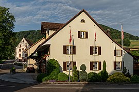
Untervogtei

Spittel

Village square
Village square


traffic

The village is located away from major thoroughfares, the main access is from Etzgen through the Mettauertal. The road continues over the Bürersteig to Remigen and finally to Brugg . Side roads lead to Gansingen , Mandach and Villigen . Hottwil is connected to the public transport network by the Brugg– Laufenburg post bus line.
literature
- Michael Stettler , Emil Maurer : The art monuments of the canton of Aargau . Ed .: Society for Swiss Art History . Volume II: The districts of Brugg, Lenzburg. Birkhäuser Verlag, Basel 1953, DNB 750561750 .
- Team of authors Max Baumann et al .: Hottwil: History of a village in the Aargau Jura . Ed .: Municipality of Hottwil. Hottwil 2007, ISBN 978-3-03301311-7 .
Web links
- Felix Müller: Hottwil. In: Historical Lexicon of Switzerland .
- Hottwil on mettauertal.ch
Individual evidence
- ↑ a b Beat Zehnder: The community names of the canton of Aargau . In: Historical Society of the Canton of Aargau (Ed.): Argovia . tape 100 . Verlag Sauerländer, Aarau 1991, ISBN 3-7941-3122-3 , p. 207 .
- ^ National map of Switzerland, sheet 1049, Swisstopo
- ↑ Aargauer Zeitung : Five clear yeses to the merger, March 21, 2008.
- ^ Joseph Galliker, Marcel Giger: Municipal coat of arms of the canton of Aargau . Lehrmittelverlag des Kantons Aargau, book 2004, ISBN 3-906738-07-8 , p. 181 .
- ↑ Population development in the municipalities of the Canton of Aargau since 1850. (Excel) In: Eidg. Volkszählung 2000. Statistics Aargau, 2001, archived from the original on October 8, 2018 ; accessed on May 8, 2019 .
- ↑ Swiss Federal Census 2000: Economic resident population by religious affiliation as well as by districts and municipalities. (Excel) Statistics Aargau, archived from the original on August 10, 2018 ; accessed on May 8, 2019 .
- ↑ Swiss Federal Census 2000: Economic resident population by main language as well as by districts and municipalities. (Excel) Statistics Aargau, archived from the original on August 10, 2018 ; accessed on May 8, 2019 .
Auenstein | Birr | Birrhard | Brugg | Bözberg | Bözen | Effingen | Elfingen | Habsburg | Hausen | Lupfig | Mandach | Mönthal | Garbage | Remigen | Riniken | Rüfenach | Schinznach | Thalheim | Veltheim | Villigen | Villnachern | Windisch
Former communities:
Altenburg |
Gallenkirch |
Hottwil |
Lauffohr |
Linn |
Oberbözberg |
Upper flax |
Pure |
Joke |
Schinznach-Bad |
Schinznach village |
Stilli |
Umiken |
Untersözberg
Canton of Aargau | Districts of the Canton of Aargau | Municipalities in the Canton of Aargau