Bürersteig
| Bürersteig pass summit | |||
|---|---|---|---|
|
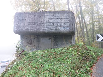
Pass height with bunker A 3902 |
|||
| Compass direction | North | south | |
| Pass height | 550 m above sea level M. | ||
| Canton | Aargau | ||
| Watershed | Mettauer Bach, Rhine | Schmittenbach, Aare , Rhine | |
| Valley locations | Etzgen | Stilli | |
| expansion | Street | ||
| Lock | - | ||
| Map (Switzerland) | |||
|
|
|||
| Coordinates | 654 265 / 264 426 | ||
The Bürersteig is a Switzerland he pass in the canton of Aargau , which with its major axis Etzgen ( Mettauertal ) on the Rhine with Stilli on the Aare joins. It is also an intersection and part of the Bürersteig barrier . Koblenz am Rhein and Effingen ( Bözberg ) are connected as a secondary axis .
The infantry bunker A 3902 from the Second World War is at the top of the pass . The Bürersteig is on the Fricktaler Höhenweg .
Web links
Commons : Bürersteig - collection of images, videos and audio files

