Haggenegg
| Haggenegg | |||
|---|---|---|---|
|
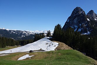
The top of the pass before Haggenspitz and small Mythen |
|||
| Compass direction | west | east | |
| Pass height | 1414 m above sea level M. | ||
| Canton | Schwyz | ||
| Valley locations | Schwyz | Brunni SZ | |
| expansion | asphalt | Mule track | |
| profile | |||
| Ø pitch | 12.9% (878 m / 6.8 km) | 7.4% (325 m / 4.4 km) | |
| Map (Schwyz) | |||
|
|
|||
| Coordinates | 694 653 / 211914 | ||
The Haggenegg is a 1414 m above sea level. M. high pass, which connects Alpthal and Schwyz in the canton of the same name .
location
Nätschboden and the Hochstuckli rise north of the Haggenegg, the Haggenspitz and the Mythen to the south . At the top of the pass there is a simple chapel, reopened in 2010, and the Haggenegg mountain inn with 50 guest beds. An inn was mentioned here as early as 1483.
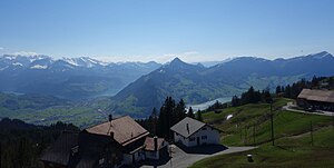
From there you have a good view of the western Lake Lucerne . The pass is accessible from Schwyz by a paved road that continues unpaved to Alpthal.
meaning
The transition played an important role in the fairy tale dispute between the abbot of Einsiedeln and the people of Schwyz. The Voralpenpass was the highest point of the Way of St. James on Swiss soil, on the way from the pilgrimage site and monastery Einsiedeln to Lake Lucerne or to Flüeli-Ranft . Even today, the hiking trail is one of the popular easy hiking routes on the trail of the St. James pilgrims.
Web links
credentials
- ^ Family Niederberger-Suter, Haggenegg
- ↑ The new Haggenegg pilgrim chapel ( page no longer available , search in web archives ) Info: The link was automatically marked as defective. Please check the link according to the instructions and then remove this notice. on mythenregion.ch, accessed April 24, 2015 (PDF)
- ↑ Monika Hanna: The Swiss Way of St. James . FA Herbig Verlagbuchhandlung, Munich 2014, ISBN 978-3-7243-1053-2 , p. 143 ff .


