
Bernina Pass
| Bernina Pass Pass dal Bernina / Passo del Bernina |
|||
|---|---|---|---|
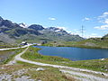
 View from the Diovalezza cable car to the Bernina Pass with the pass road and railway line, Ospizio Bernina station in the center of the picture at Lago Bianco. |
|||
| Compass direction | North | south | |
| Pass height | 2235 m above sea level M. | ||
| Canton |
|
||
| Watershed | Berninabach → Inn → Danube | Acqua da Pila → Poschiavino → Adda → Po | |
| Valley locations | Samedan | Poschiavo | |
| expansion | Rail and road | Train, (street: east route) |
|
| Built | 1842-1865 | ||
| Lock | open all year round | ||
| Mountains |
Bernina Alps (West) Livigno Alps (East) |
||
| profile | |||
| Ø pitch | 3.0% (600 m / 20 km) | 7.5% (1278 m / 17 km) | |
| Max. Incline | 10% | ||
 |
|||
| map | |||
|
|||
| Coordinates | 797 691 / 143665 | ||

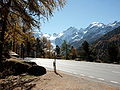
The Bernina Pass , Rhaeto-Romanic Pass dal Bernina , Italian Passo del Bernina is an Alpine pass in the Swiss canton of Graubünden , which lies at an altitude of 2235 m above sea level. M. connects the Engadine in the north with the Puschlav and the Italian Valtellina in the south. The apex of the pass road is a little further east at 2328 m above sea level. M.
geography
The Bernina Pass lies between the Bernina and Livigno Alps on the Black Sea / Adriatic watershed between the two lakes Lej Nair (Black Lake) and Lago Bianco (White Lake). The Lej Nair flows north over the Bernina stream and belongs to the catchment area of the Inn , the Lago Bianco flows south over Acqua da Pila and Poschiavino and belongs to the catchment area of the Po . This is where the border between the Romansh and Italian language areas runs. In a southerly direction, you can descend to San Carlo di Poschiavo via Cavaglia via Val da Pila on the Bernina west route. This route is used by the Bernina Railway.
The road pass, commonly known as the Bernina Pass, is 93 meters higher and overcomes the ridge between the Val da Pila and the Val Laguné. This route is also known as the Bernina East Route. The mountain inn Ospizio Bernina is located near the top of the pass at Lagh da la Cruseta , the railway station of the same name is located to the south-west below on the banks of Lago Bianco.
Climate table
| Bernina Pass, 1981-2010 | ||||||||||||||||||||||||||||||||||||||||||||||||
|---|---|---|---|---|---|---|---|---|---|---|---|---|---|---|---|---|---|---|---|---|---|---|---|---|---|---|---|---|---|---|---|---|---|---|---|---|---|---|---|---|---|---|---|---|---|---|---|---|
| Climate diagram | ||||||||||||||||||||||||||||||||||||||||||||||||
| ||||||||||||||||||||||||||||||||||||||||||||||||
|
Average monthly temperatures and rainfall for the Bernina Pass, 1981–2010
Source:
|
||||||||||||||||||||||||||||||||||||||||||||||||||||||||||||||||||||||||||||||||||||||||||||||||||||||||||||||||||||||||||||||||||||||||||||||||||||||
history
prehistory
The Bernina represents a millennia-old connection between the millennia-old cultural landscapes of the Upper Engadine around St. Moritz and the Valtellina . Numerous finds were made not only in St. Moritz that date back to the Bronze Age, but also on the other side of the Bernina Valtellina. Among other things , at Teglio , the Roman Tillium , which probably gave the Valtellina, the Val Tillium , its name, numerous stone-age menhirs with enigmatic incised drawings, as found in large parts of Europe, were found. From such finds it can be concluded that there was already pass traffic over the Bernina in prehistoric times, which also increased in Roman times. Still, the Bernina was never really an important passport. The ascent only began in the High Middle Ages, in the late Middle Ages the pass actually gained a certain importance for trade. Nevertheless, the Bernina was always in the shadow of neighboring passes such as the Malojas or Ofenpass .
Modern times

The pass forms the main artery between the Engadin and the Valtellina. Compared to Septimer and Splügen at a disadvantage due to their peripheral location, there was never a transalpine transit route of European importance via the Bernina . The communities were responsible for the road maintenance; the porten (transport cooperatives) played a rather subordinate role. The topographically favorable regional connection became more important when the Three Leagues conquered the Valtellina in 1512 and thus gained the Republic of Venice as a border neighbor. Around 1550 France set up a permanent courier service between Lyon and Venice over the Albula , Bernina and Aprica passes .
Strictly speaking, the Bernina Pass is two parallel paths that lead south into Val Laguné and into the Cavaglia basin ; Armon Planta calls them Bernina-Ost and Bernina-West for short . Which route was preferred changed several times over the course of time, also depending on the season, snow conditions and the current condition of the paths. The overall shorter west route runs on a longer stretch above the tree line and is therefore more at risk from avalanches and snowdrifts. Documents prove the expansion of the west route in 1552 and the east route in 1645. After serious avalanche accidents occurred in 1729 and 1779, it was forbidden to use the west route in winter. The most important transport goods of were at times merchant traffic wine and grain transported to the north, cattle and cheese to the south. The hamlet of La Rösa on the south side of the pass is a historic mule station .
When the road was built in 1842, it was decided to go for Bernina East; Rudolf Albertini (1821–1896) von Zuoz did the engineering work with the help of the chief engineer Richard La Nicca from Graubünden . The work was completed in 1865 and the hospice, located at 2307 m just west of the apex, was opened. The road, which has been widened several times since then, has been kept open all year round since 1965, although there is snow on the pass for around eight months of the year. This makes the Bernina Pass one of the highest year-round open passes in the Alps.
During the two world wars, the Bernina Pass was fortified against attackers from the Poschiavo at the Bernina houses barrier .
Bernina Railway and Cable Cars
The meter-gauge Bernina Railway, which opened in the first sections in 1908 and was electrically operated from the start , has crossed the pass since 1910, and in winter since 1913. The route laid out with a view to good tourist development of the scenic beauties largely follows the Bernina-West route. With its summit height of 2253 m at the Ospizio Bernina station , it is considered the highest alpine transversal. Dam walls were built at the north and south ends of Lago Bianco to use the water power. The usable content of the reservoir is around 18 million cubic meters.
Since 1956, the Bernina-Diavolezza cable car has opened up a glacier ski area on the Munt Pers on the north side of the pass; it was renewed in 1980. A cable car has been leading up to Piz Lagalb since 1963 .

Bernina Pass with Cambrena Glacier, 1867

Hospice and pass road around 1904

Bernina Pass Road and Lagh de la Cruseta
Ospizio Bernina and Lagh da la Cruseta

Cambrena Glacier 1992

Passover
Bernina group

Bernina Railway on Piz Prüna
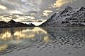
Black ice on Lago Bianco 2016


.JPG)


literature
- Martin Bundi: Bernina Pass. In: Historical Lexicon of Switzerland . March 3, 2011 .
- Armon Planta: Traffic routes in ancient Raetia. Volume 1, Verlag Bündner Monatsblatt, Chur 1990, ISBN 3-905241-11-0 .
Web links
- Bernina Pass on the ETHorama platform
- www.berninabahn.ch for historical views of the Berninabahn
Individual evidence
- ↑ a b Location & height of the pass according to SwissTopo
- ↑ Location and height of the road pass according to SwissTopo
- ↑ Lej Nair on ethorama.library.ethz.ch/de/node
- ↑ Climate table. In: meteoschweiz.admin.ch. meteoschweiz, accessed on May 31, 2018 .
- ↑ Steffan Bruns: Alpine passes - history of the alpine pass crossings. From the Inn to Lake Garda . tape 3 . L. Staackmann Verlag KG, Munich 2010, ISBN 978-3-88675-273-7 , p. 33 .
Ächerli • Agites • Aiguillon • Albis • Albula • Balmberg • Benkerjoch • Bernina • Böhler • Bözberg • Breitehöchi • Brünig • Buechenegg • Bürersteig • Chall • Challhöchi Pass • Champex • Chasseral • Chatzenstrick • Chilchzimmersattel • Croix • Croix • Croix de Coeur • Eichhöhe • Étroits • Etzelpass • Flüela • Forclaz • Furka • Ghöch • Givrine • glass • Glaubenberg • Glaubenbielen • Gottschalkenberg • Grimsel • Grosse Scheidegg • Gr.St.Bernhard • Gurnigel • Haggenegg • Hahnenmoos • Heitersberg • Hilferen • Hirzel • Hirzel Höhi • Hulftegg • Ibergeregg • Jaman • Jaun • Julier • Kerenzerberg • Klausen • Kunkels • Lein • Lenzerheide • Livigno • Lukmanier • Maloja • Marchairuz • Mollendruz • Mont Crosin • Monte Ceneri • Mont d'Orzeires • Montvoie • Morgins • Mosses • Mutschellen • Neggia • Nufenen • Oberalp • upper Hauenstein • Oberricken • oven • Orn • Passwang • Pierre Pertuis • Pillon • Planches • Pontins • Pragel • edge crossing • Rangiers • rates • Rengg • crocheted • Roches • 'groups • R üsler • Saanenmöser • Salhöhe • San Bernardino • Sanetsch • Santelhöchi • Sattel • Sattelegg • Schafmatt • Schallenberg • Schelten • Schönau • Schufelberger Egg • Schwägalp • Schwarzenbühl • Siblingerhöhe • Simplon • Splügen • St. Anton • St. Gotthard • St. Luzisteig • Staffelegg • Stoss • Susten • Tourne • Tronc • Umbrail • Unterer Hauenstein • Front Höhi • Vue des Alpes • Wasserfluh • Weissenstein • Wildhaus • Wissegg • Wolfgang