
Flüela Pass
| Flüela Pass | |||
|---|---|---|---|
 Flüelapasshöhe seen from the Davos side |
|||
| Compass direction | west | east | |
| Pass height | 2383 m above sea level M. | ||
| Canton | canton of Grisons | ||
| Watershed | Flüelabach → Landwasser → Albula → Hinterrhein → Rhine | Susasca → Inn → Danube | |
| Valley locations | Davos | Susch | |
| expansion | Street | ||
| Built | 1866-1867 | ||
| Winter closure | November – May | ||
| profile | |||
| Ø pitch | 6.3% (822 m / 13 km) | 7.5% (958 m / 12.80 km) | |
| Max. Incline | 12% | 10% | |
 |
|||
| map | |||
|
|||
| Coordinates | 791651 / 180710 | ||

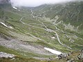
The Flüelapass (Flüela is diminutive of Fluh , Swiss German Flueh for 'rock face, rocky area') is a 2383 m high mountain pass in Switzerland between Davos in the Landwassertal and Susch in the Lower Engadine . It lies between the Schwarzhorn ( 3147 m ) and the Flüela Wisshorn ( 3085 m ). The main European watershed runs over it .
history
The Flüelapass, created in 1867, is the shortest road route between the Rhine Valley and the Lower Engadine. During the Second World War , the pass, like the Splügen , Julier and Albula, should be permanently closed until the army was deployed. From May 1938, the office for fortification structures (BBB) created the Flüelapass barrier with the barrier at the Chanta Sura bridge, the main plant Flüela on the right (A 7701) and the counter-plant Flüela on the left (A 7702).
traffic
The pass is not safe for winter, the route runs through an avalanche prone area. Since the opening of the nearby Vereina tunnel in 1999, it has been closed for the winter months. In summer, Postbus courses ( Bergpoststrasse ) run on the Flüelapassstrasse between Davos and the Engadine. In the summer season, a historic stagecoach drives every Tuesday from Davos Platz train station to the Flüela Hospiz and back. It is possible to ride the route there and back or to book only a part of the route. Due to the cooperation with PostBus Graubünden, the ticket is also valid on the day of travel on the PostBus line on the Flüela route.
tourism
The Flüelapass is the end point of the Bündner Hauteroute , a long-distance hiking trail that starts at the Julierpass and runs through the high mountain landscape in the north of the Engadine.
Use in winter
The association Pro Flüela sits down since the opening of the Vereina for keeping open the passport using the winter months. Winter maintenance of the pass road in the area of the Davos landscape has been carried out again since 2004 and the road is used by BMW for test drives.
panorama

gallery
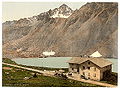
Flüela Hospice around 1900
Flüela Hospice 2006

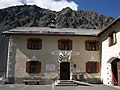
Information sign on the Flüela Hospice
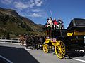
Flüela horse mail as before

A post bus on the way on the Flüelapass
Flüela Pass at the end of May on the Lower Engadine side
Pass road south of the hospice

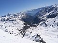
View in July


literature
- Jürg Simonett: Flüela Pass. In: Historical Lexicon of Switzerland . October 28, 2005 .
Web links
- The slope profile of the Flüela Pass, Davos side
- The slope profile of the Flüela Pass, Suscher side
- The Pro Flüela association
Individual evidence
- ↑ Andrea Schorta: How the mountain got its name . Small Rhaetian name book with two and a half thousand geographical names of Graubünden. Terra Grischuna Verlag, Chur and Bottmingen / Basel 1988, ISBN 3-7298-1047-2 , p. 87 .
Ächerli • Agites • Aiguillon • Albis • Albula • Balmberg • Benkerjoch • Bernina • Böhler • Bözberg • Breitehöchi • Brünig • Buechenegg • Bürersteig • Chall • Challhöchi Pass • Champex • Chasseral • Chatzenstrick • Chilchzimmersattel • Croix • Croix • Croix de Coeur • Eichhöhe • Étroits • Etzelpass • Flüela • Forclaz • Furka • Ghöch • Givrine • glass • Glaubenberg • Glaubenbielen • Gottschalkenberg • Grimsel • Grosse Scheidegg • Gr.St.Bernhard • Gurnigel • Haggenegg • Hahnenmoos • Heitersberg • Hilferen • Hirzel • Hirzel Höhi • Hulftegg • Ibergeregg • Jaman • Jaun • Julier • Kerenzerberg • Klausen • Kunkels • Lein • Lenzerheide • Livigno • Lukmanier • Maloja • Marchairuz • Mollendruz • Mont Crosin • Monte Ceneri • Mont d'Orzeires • Montvoie • Morgins • Mosses • Mutschellen • Neggia • Nufenen • Oberalp • upper Hauenstein • Oberricken • oven • Orn • Passwang • Pierre Pertuis • Pillon • Planches • Pontins • Pragel • edge crossing • Rangiers • rates • Rengg • crocheted • Roches • 'groups • R üsler • Saanenmöser • Salhöhe • San Bernardino • Sanetsch • Santelhöchi • Sattel • Sattelegg • Schafmatt • Schallenberg • Schelten • Schönau • Schufelberger Egg • Schwägalp • Schwarzenbühl • Siblingerhöhe • Simplon • Splügen • St. Anton • St. Gotthard • St. Luzisteig • Staffelegg • Stoss • Susten • Tourne • Tronc • Umbrail • Unterer Hauenstein • Front Höhi • Vue des Alpes • Wasserfluh • Weissenstein • Wildhaus • Wissegg • Wolfgang