
Schwarzhorn (Flüelapass)
| Flüela-Schwarzhorn | ||
|---|---|---|
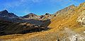
 The Schwarzhorn seen from the neighboring summit, Radüner Rothorn ( 3022 m ). |
||
| height | 3146.2 m above sea level M. | |
| location | Canton of Graubünden , Switzerland | |
| Dominance | 5.55 km → Piz Vadret | |
| Notch height | 609 m ↓ Fuorcla da Grialetsch | |
| Coordinates | 791.28 thousand / 179 118 | |
|
||
| rock | Amphibolite | |
| Normal way | Over the south ridge | |
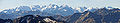
 View to NE from the summit of Flüela-Schwarzhorn |
||

The Schwarzhorn (also: Flüela-Schwarzhorn ) is located about two kilometers south of the Flüela Pass in the Swiss Alps . It is the highest point in the Davos landscape and is 3,146.2 m above sea level. M.
The Schwarzhorn got its name because of its very dark rock amphibolite, seen from the Davos side, which can be seen far around like a dark spike. The view from the Schwarzhorn is extensive and extends from the Valais Alps in the west to far into the Eastern Alps.
The Schwarzhorn is easily accessible via the path leading from the Flüela Pass, it is considered to be one of the most easily accessible 3000m peaks in the Alps. It is very popular in summer and a popular ski mountain in spring.
Location and surroundings
The Schwarzhorn is the namesake of the Schwarzhorn chain, a subgroup of the Albula Alps . The municipal boundary between Davos and Susch runs over the summit . The Black Horn is in the southwest by the Dischmatal edged and on the east by the Val Susasca.
The neighboring peaks include the Chlein Schwarzhorn ( 2968 m ), the Flüela Wisshorn ( 3085 m ), the Piz Radönt ( 3065 m ), the Radüner Rothorn ( 3022 m ), the Bocktenhorn ( 3044 m ), the Sattelhorn ( 2981 m ), the Hüreli ( 2568 m ) and the Börthorn ( 1697 m ). The Schwarzhorn is separated from the Radüner Rothorn by the Schwarzhornfurgga ( 2880 m ).
On the northern flank, the Schwarzhorn has a glacier, the Schwarzhorn Glacier.
The valley locations are Davos and Susch. Frequent starting points are the Flüelapassstrasse or the Dischma valley.
Sunrise and sunset
_3.jpg)
At the start of the Flüelapass over the south ridge (Schwarzhornweg) the ascent is relatively short and the path is easy to see. Therefore, both in summer and in winter, the Schwarzhorn is often climbed with headlamps early in the morning to be on the summit at sunrise . The sunset on the Schwarzhorn is also often admired and the way back is made at dusk.
Routes to the summit
Over the south ridge (Schwarzhornweg)
- Starting point: Flüelapassstrasse ( 2332 m , 15 min from the hospice towards Susch)
- Via: Schwarzhornfurgga
- Marked as a white-red-white hiking trail
- Difficulty: T3
- Time required: 3 hours
From the Dischma valley
- Starting point: Schürlialp ( 1957 m ) or Dürrboden ( 2007 m )
- Route: Giementälli, Schwarzhornfurgga
- Difficulty: T4
- Time required: 3 hours
From Chamanna da Grialetsch via Fuorcla da Radönt
- Starting point: Chamanna da Grialetsch ( 2542 m )
- Route: Fuorcla Radönt, Schwarzhornfurgga
- Marked as a white-red-white hiking trail
- Difficulty: T3
- Time required: 2¾ hours
From the Chamanna da Grialetsch via Rothorn Furgga
- Starting point: Chamanna da Grialetsch ( 2542 m )
- Route: Rothorn Furgga, Radüner Rothorn or Vadret da Radönt, Schwarzhornfurgga
- Difficulty: T4
- Time required: 2½ hours
Over the southwest ridge
- Starting point: Schürlialp ( 1957 m ) or Dürrboden ( 2007 m )
- Difficulty: ZS-
- Time required: 3½ hours
Over the north ridge
- Starting point: Flüela-Ospiz ( 2383 m ) or Schürlialp ( 1957 m )
- Difficulty: ZS
- Time required: 3½-4 hours
Over the east ridge
- Starting point: Flüelapassstrasse ( 2391.5 m )
- Difficulty: WS
- Time required: 3 hours
Winter route from the Flüela Pass
- Starting point: Flüelapassstrasse ( 2303.2 m ), 1.5 km southeast of the Flüela-Ospiz, on the Engadine side
- Via: Schwarzhornfurgga
- Difficulty: good skier
- Time required: 2½ hours
- Alternative: From Flüela-Ospiz ( 2383 m ) directly to the southeast under P. 2780 to Schwarzhornfurgga
- Departure: ascent route
Winter route from the Chamanna da Grialetsch
- Starting point: Chamanna da Grialetsch ( 2542 m )
- Route: Fuorcla da Grialetsch, Fuorcla Radönt, Vadret da Radönt, Schwarhornfurgga
- Difficulty: good skier
- Time required: 3 hours
- Departure: ascent route
panorama

gallery
From left to right: Piz Radönt 3065 m , Radüner Rothorn 3022 m and on the right Flüela Schwarzhorn 3146 m
Panorama of the Bernina group from the Flüela-Schwarzhorn. Just to the left of the center of the picture is the Biancograt, to the left of it Piz Palü.

Flüela Pass seen from the Schwarzhorn.
Flüela Wisshorn seen from the Schwarzhorn.

Sunrise on the Schwarzhorn.

Sunrise on the Schwarzhorn.


_7.jpg)
literature
- Eugen Wenzel: Club Guide, Bündner Alpen, Volume 6 (Albula) 2nd edition. Verlag des SAC, 1980, ISBN 3-85902-012-9 , pp. 207-209.
- Georg Calonder: Alpine Skitouren, Volume 2 (Graubünden) 4th edition. Verlag des SAC, 1992, ISBN 3-85902-060-9 , pp. 259-260.
- National map of Switzerland, sheet 1217 Scalettapass, 1: 25000, Federal Office of Topography, 1979 edition
Web links
- Panorama from the Schwarzhorn ( Memento from January 15, 2013 in the web archive archive.today )
- www.hikr.org Tour report
- Schwarzhorn on summitpost
Individual evidence