
Ibergeregg
| Ibergeregg | |||
|---|---|---|---|
 Ibergeregg |
|||
| Compass direction | west | east | |
| Pass height | 1406 m above sea level M. | ||
| Canton | Schwyz | ||
| Valley locations | Schwyz | Unteriberg | |
| expansion | Pass road | ||
| Lock | open all year | ||
| profile | |||
| Ø pitch | 8.1% (890 m / 11 km) | 5.3% (481 m / 9.1 km) | |
| Max. Incline | 10.1% | 8.3% | |
| Map (Schwyz) | |||
|
|||
| Coordinates | 698 434 / 208195 | ||

The Ibergeregg is a Swiss pass in the canton of Schwyz , which connects the villages of Schwyz and Oberiberg over a pass length of 17 kilometers . The area is a holiday resort with two ski lifts, a campsite and a rich flora and fauna .
geography
The pass is at 1406 m above sea level. M. about six kilometers as the crow flies east of the canton capital Schwyz. To the north of the pass lies the Furggelenstock ( 1656 m above sea level ), south of it the Firstspitz ( 1624 m above sea level ).
East of the Ibergeregg is the source area of the Minster , which later feeds the Sihl . The area is west of Muota drained and belongs to Muotatal . On the Ibergeregg, there are numerous high and lowland moors ; it is a cantonal nature reserve.
In a north-easterly direction, the pass road continues through the municipality of Unteriberg to the Sihlsee and to Einsiedeln with the baroque monastery Einsiedeln . The western end of the road is in Schwyz, where there is a connection to Zurich and Lucerne via the A4 autobahn and the A2 towards Gotthard .
Looking south to the Uri Alps

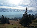
View to the west to Lake Lucerne, which is hidden under a sea of fog

Clubhouse Donkey Kick (1941)


history
From the late Middle Ages , a mule track led across the Ibergeregg. It was part of the old Schwyzerweg , which was built in the 14th century as the shortest connection from Iberg to Schwyz. The first road was opened to traffic in 1873. Since 1947 there has been a bus connection between Schwyz and Oberiberg in summer. In 1961 the Marienkapelle was inaugurated. In 2019 the moor forests of the Ibergeregg were named landscape of the year .
Since 1933 the ski and club house Eseltritt of the SAC Am Albis has been located 1.5 km below the Ibergeregg pass in the direction of Schwyz .
Web links
- Official website
- Erwin Horat: Ibergeregg. In: Historical Lexicon of Switzerland .
- Gradient profile from the direction of sticks
- Gradient profile from the direction of Rickenbach
Individual evidence
- ^ List of flat moors of national importance
- ^ List of moorlands of particular beauty and of national importance
- ↑ Ordinance on the use and protection of the Ibergeregg ( Memento of the original from March 4, 2016 in the Internet Archive ) Info: The archive link was automatically inserted and not yet checked. Please check the original and archive link according to the instructions and then remove this notice. (PDF; 66 kB)
- ↑ Landscape of the year 2019 chosen. In: bauernzeitung.ch. May 8, 2019, accessed May 8, 2019 .
Ächerli • Agites • Aiguillon • Albis • Albula • Balmberg • Benkerjoch • Bernina • Böhler • Bözberg • Breitehöchi • Brünig • Buechenegg • Bürersteig • Chall • Challhöchi Pass • Champex • Chasseral • Chatzenstrick • Chilchzimmersattel • Croix • Croix • Croix de Coeur • Eichhöhe • Étroits • Etzelpass • Flüela • Forclaz • Furka • Ghöch • Givrine • glass • Glaubenberg • Glaubenbielen • Gottschalkenberg • Grimsel • Grosse Scheidegg • Gr.St.Bernhard • Gurnigel • Haggenegg • Hahnenmoos • Heitersberg • Hilferen • Hirzel • Hirzel Höhi • Hulftegg • Ibergeregg • Jaman • Jaun • Julier • Kerenzerberg • Klausen • Kunkels • Lein • Lenzerheide • Livigno • Lukmanier • Maloja • Marchairuz • Mollendruz • Mont Crosin • Monte Ceneri • Mont d'Orzeires • Montvoie • Morgins • Mosses • Mutschellen • Neggia • Nufenen • Oberalp • upper Hauenstein • Oberricken • oven • Orn • Passwang • Pierre Pertuis • Pillon • Planches • Pontins • Pragel • edge crossing • Rangiers • rates • Rengg • crocheted • Roches • 'groups • R üsler • Saanenmöser • Salhöhe • San Bernardino • Sanetsch • Santelhöchi • Sattel • Sattelegg • Schafmatt • Schallenberg • Schelten • Schönau • Schufelberger Egg • Schwägalp • Schwarzenbühl • Siblingerhöhe • Simplon • Splügen • St. Anton • St. Gotthard • St. Luzisteig • Staffelegg • Stoss • Susten • Tourne • Tronc • Umbrail • Unterer Hauenstein • Front Höhi • Vue des Alpes • Wasserfluh • Weissenstein • Wildhaus • Wissegg • Wolfgang