
Unteriberg
| Unteriberg | |
|---|---|
 |
|
| State : |
|
| Canton : |
|
| District : | Schwyz |
| BFS no. : | 1375 |
| Postal code : |
8842 (Unteriberg) 8845 (Studen) |
| UN / LOCODE : | CH UTB |
| Coordinates : | 703 690 / 213 287 |
| Height : | 925 m above sea level M. |
| Height range : | 888–2212 m above sea level M. |
| Area : | 46.43 km² |
| Residents: | 2395 (December 31, 2018) |
| Population density : | 52 inhabitants per km² |
|
Proportion of foreigners : (residents without citizenship ) |
6.8% (December 31, 2,015) |
| Website: | www.unteriberg.ch |
 Unteriberg |
|
| Location of the municipality | |
  |
|
Unteriberg is a municipality in the district of Schwyz in the canton of Schwyz in Switzerland . These include the districts of Studen, Waag, Stöcken and Herti.
coat of arms
A stylized yew tree is depicted on the coat of arms of Unteriberg. It bears red fruits and stands on a green mountain of three. The background is white (silver).
geography
The valleys of the Sihl , the Waag and the Minster come together in Unteriberg . They form an alluvial plain here. During the last ice age, the Sihl glacier tongues shaped the terrain. Today's Sihlsee area and the entire valley floor was originally a raised bog area . The field names with the addition of Ried attest to this fact. In addition to the valley floor, the woodless alpine pastures on the slopes of the valley and hilly landscape towards the Drusberg , Fluebrig and Stock mountains are of great importance for agriculture.
The municipality of Unteriberg is around 900 m above sea level and extends in the Höch-Hund up to 2215 m above sea level. The forest share is 35%, 45% of the community area is used for agriculture and 18% is unproductive.
population
| Population development | |
|---|---|
| year | Residents |
| 1884 | 1389 |
| 2003 | 2287 |
| 2009 | 2339 |
From 1988 to 1998 Unteriberg experienced the greatest increase with around 600 people. Nine tenths of the population are Roman Catholic , one tenth are Protestant-Reformed denominations and around 1% are members of other faiths or are non-denominational.
Meinrad Lienert wrote about the inhabitants : «And like the Alps, like the valleys of Unter-Iberg, so are the inhabitants: homely, friendly and genuine. You just take life from the sunny side ... It's a funny, awakened crowd. "
politics
The strongest party, the SVP, has 74%, the SP 7%, the CVP 13%, and the FDP 6% of the vote.
In the atlas of political landscapes , the municipality is considered to be the most conservative in Switzerland.
economy

Wood processing companies have established themselves in the farming community of Unteriberg, as well as several joiners 'and carpenters' shops and sawmills. The construction of the Hesisbohl cable car , now called Hoch-Ybrig , brought an upswing in the valley. Tourism is an important economic factor, especially in winter.
The Ochsenboden test center of Rheinmetall Defense and the Ybrig Golf Club, which opened in 2000, are located in Ochsenboden ( Studen district ) . The factory shooting range of the machine tool factory Oerlikon-Bührle AG, founded in 1953, was taken over in 1990 by RWM Schweiz AG (formerly Oerlikon Contraves Pyrotec AG). The main tasks of the test center include extensive tests on weapons, ammunition and other military systems. In the sixties, shooting tests with uranium ammunition were carried out in Ochsenboden .
55% of the gainfully employed find work in around 190 companies, 45% commute to Einsiedeln or the Zurich agglomeration .
traffic
For private traffic, the nearest motorway connections ( A3 ) are in Richterswil or via the Ibergereggstrasse, which is open all year round, in Seewen . Postbus courses run to Einsiedeln to the SOB train station and in summer also to Schwyz.
history

The Iberg is mentioned for the first time in a document in 1350. The name was derived from the yew , a common conifer in Unteriberg. The tough wood of the tree was then used to make tools and weapons.
After long disputes, the former community of Iberg was divided into Ober- and Unteriberg in a cantonal referendum in 1884. This made Unteriberg the youngest municipality in the canton of Schwyz. Although it can only be reached from Schwyz via the Ibergeregg, the area was more connected to Schwyz than to Einsiedeln until modern roads were built in 1855 .
The economic connection to Einsiedeln did not take place until 1877, with the opening of the railway line Einsiedeln - Wädenswil (- Zurich ). In the same year a horse mail line was set up with Einsiedeln, which was converted to bus service in 1923.
Attractions
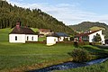
photos

Parish Church of St. Joseph

Schoolhouses

school

Multipurpose house

Retirement home and minster

Waagtalstrasse
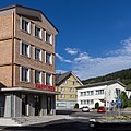
Raiffeisen, Brunnen and Post
Studen: parish church, cemetery chapel, schoolhouse

Studen: school house


Personalities
- Marcel Fässler , racing car driver
- Patricia Fässler , Miss Switzerland 1993
- Sepp Fuchs , bicycle racer
- Wendy Holdener , ski racer
- Jost Marty , composer of folk music
- Hanspeter Trütsch , television reporter
- Franz Fassbind , writer, playwright and journalist
literature
- Linus Birchler : The art monuments of the canton Schwyz, Volume II: The districts Gersau, Küssnacht and Schwyz. Art historical overview. (= Swiss art monuments. Volume 2). Edited by the Society for Swiss Art History GSK. Bern 1930.
Web links
- Official website of the community of Unteriberg
- Erwin Horat: Unteriberg. In: Historical Lexicon of Switzerland .
- Ibaum. In: Jacob Grimm , Wilhelm Grimm (Hrsg.): German dictionary . tape 10 : H, I, J - (IV, 2nd division). S. Hirzel, Leipzig 1877, Sp. 2016 ( woerterbuchnetz.de ).
Individual evidence
- ↑ Permanent and non-permanent resident population by year, canton, district, municipality, population type and gender (permanent resident population). In: bfs. admin.ch . Federal Statistical Office (FSO), August 31, 2019, accessed on December 22, 2019 .
- ↑ Resident population in the canton of Schwyz as of December 31 , 2015 ( Memento from May 4, 2016 in the Internet Archive )
- ^ Hermann M., Leuthold H .: Atlas of the political landscapes . vdf, Zurich 2003.
- ↑ ssn.ethz.ch ( page no longer available , search in web archives ) Info: The link was automatically marked as defective. Please check the link according to the instructions and then remove this notice.
Alpthal |
Arth |
Illgau |
Ingenbohl |
Lauerz |
Morschach |
Muotathal |
Oberiberg |
Riemenstalden |
Rothenthurm |
Saddle |
Schwyz |
Stones |
Steinerberg |
Unteriberg
Former municipality: Iberg
Canton of Schwyz | Districts of Canton Schwyz | Municipalities in the canton of Schwyz