
Illgau
| Illgau | |
|---|---|
 |
|
| State : |
|
| Canton : |
|
| District : | Schwyz |
| BFS no. : | 1363 |
| Postal code : | 6434 |
| UN / LOCODE : | CH ILG |
| Coordinates : | 697 834 / 204880 |
| Height : | 807 m above sea level M. |
| Height range : | 753–1784 m above sea level M. |
| Area : | 10.95 km² |
| Residents: | 802 (December 31, 2018) |
| Population density : | 73 inhabitants per km² |
|
Proportion of foreigners : (residents without citizenship ) |
2.2% (December 31, 2,015) |
| Website: | www.illgau.ch |
 Illgau |
|
| Location of the municipality | |
  |
|
Illgau is a municipality in the district of Schwyz in the canton of Schwyz in Switzerland .
geography

Illgau is located in the central Swiss Alps, between the Muotathal and the Ibergeregg . Its topography is largely directed towards the south and south-west. Illgau therefore rightly bears the nickname "sun terrace". The Fallenfluh, the Sternenegg, the Spyrstock in the Hoch-Ybrig area and the Hessisbohler First with the Hochweidgütsch as a branch form the municipality boundaries. Towards the Muotathal, the sudden floods from the Sulzmatt to the Fallenfluh are sometimes very impressive and remarkable. The waters of the «Bettbach», the Illgau Dorfbach, and the «Mettelbach», which flies from the rear of the Oberberg down to the valley and flows towards the Muota, rush over these mountain ridges. From the lowest community point in the Dorf region to the highest community point, the Huusmätteli on the Hessisbohlerfirst, the difference is almost exactly 1000 meters in altitude.
The community area is divided into the village , the Vordern Oberberg - towards the Ibergeregg -, the Hinteren Oberberg - towards the Hoch Ybrig - and the uninhabited area of the Rieter and Alps. Neighboring communities are Muotathal in the south, Schwyz in the west and north, and Oberiberg in the northeast.
population
| Population development | |
|---|---|
| year | Residents |
| 1798 | 162 |
| 1870 | 278 |
| 2002 | 773 |
| 2013 | 801 |
The population is 99% German-speaking.
politics
The only organized party in the community is the CVP, the Illgau Christian Democratic Party. Mayor is Markus Bürgler (as of 2010).
coat of arms
The young coat of arms of the Illgau municipality shows a lily on a green three-mountain and on a red background. The fire lily is called gold rose in the dialect, but also "Ilge", which is probably the reason why Illgau found this flower in the coat of arms.
Surname
Where the name Illgau comes from cannot be proven, rather not from the beautiful lily. A first settler or landowner in the municipality - of Alemannic origin - was probably a person named Yllo (or something like that), which is why the area was called Gau (area) des Yllo.
economy
The Illgau community is strongly influenced by agriculture. The farms are widely spread, up to 1300 m they are cultivated all year round. The agricultural area is 62%, the forest 31% of the municipal area.
Some trade and tourism has established itself, nevertheless 58% of the employed find their work outside the community.
traffic
The access is from Schwyz in the direction of Muotathal and after 6 kilometers via the 3.5 km long road to Illgau. The Ibergeregg pass road connects the Vorderen Oberberg with Schwyz and Oberiberg. There are connecting roads from the village towards Ibergereggstrasse and Hinter Oberberg.
The public connection is made by the Schwyz – Muotathal bus line via the Illgau – Ried cable car. Another gondola lift leads from Illgau Dorf to St. Karl / Oberberg.
history
11th century - in the area of the «Vorder Oberberg» - in Chileguet, in the Wart and in the Zimmerstalden - people live all year round. Remnants of the wall from the so-called Heidenhüttli are evidence of this settlement.
1303 - The Illgau residents receive permission from the Bishop of Constance to build a church.
1393 - on August 13th, according to a document in Illgau, a priest's pound is established.
1611 - 14 residents die of the plague while going to church in Illgâu (record of the Rev. von Euw, Muotathal)
1676 - on March 6th, the Illgau parish is separated from Muotathal
End of the 18th century - in the years 1798–1799, the French era did not pass Illgau without a trace, among other things with the billeting of 4000 soldiers
1848 - on February 27th Illgau becomes an independent political municipality
1893 - October 14th, consecration of the parish church by the Chur bishop Battaglia. Church patrons are the Three Wise Men. The church was built according to plans by Father Albert Kuhn, Einsiedeln Abbey (source: Steinmetzvertrag, May 7, 1893, Illgau parish archive), incorporating the foundation walls of the previous church in neo-Romanesque style. Much hard labor was done by the local population .
1911 - Construction of the Grünenwald – Illgau road. This is a narrow freight road that is closed in the winter months due to the risk of avalanches. The Fluhweg - the ancient footpath down into the Muotatal - is still popular today as a hiking trail.
1938 - Construction of the electricity network and supply of electricity to most homes
1951 - Construction of the Illgau – Ried aerial cableway
1955 - Construction of the Illgau – Vorder Oberberg / St. Karl
1958 - Construction of a new parish church
1965 - construction of a new school building
1973 - Expansion of the road from the "Grünenwald" to Illgau with the core of the new road tunnel and the avalanche gallery
The 1970s marked a quantum leap in the development of the community. During this time, the access roads for the homes to Hintern Oberberg and the road to Vorder Oberberg will be built. Illgau receives building regulations, a water supply and the sewer system.
Arts and Culture
Illgau folk music in its originality is known throughout the country. The “Illgau style” is a trademark in circles of folk music lovers. The calm, drawn and melodiously simple style of this pleasing music can be used for social occasions on the dance floor as well as for contemplative moments at church services. This music is played in formation of three with two hand organs and a string bass. This line-up can also be supplemented with clarinet / saxophone or with piano accompaniment. Country music is playing around ten bands. Feldmusik Illgau has existed since 1898. The Zitherspielgruppe, a group of women, do old dances on their Schwyzer zithers. Some bands also successfully cultivate modern music.
In addition to instrumental music, vocal music is also part of the village culture. The church choir, which is probably over 100 years old, has been involved for the longest. The Cäcilienverein was formally founded in 1946. The yodelling club and some family groups, which have the yodelling song and old folk songs in their repertoire, round off the musical Illgau. The majority of households have an instrument at home. Illgau is one of the most musical places in Switzerland.
photos
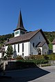
church

historical Sigristenhaus

Cable car to St.Karl


Personalities
- Karl Bürgler (* 1943), Bishop, Vicar Apostolic of Reyes, Bolivia
- Othmar Reichmuth (* 1964), Government Councilor of the Canton of Schwyz, Council of States
Partner municipality
Illgau has had a community partnership with Rodna in Romania since August 2017 .
literature
- Linus Birchler : The art monuments of the canton Schwyz, Volume II: The districts Gersau, Küssnacht and Schwyz. Art historical overview. (= Swiss art monuments. Volume 2). Edited by the Society for Swiss Art History GSK. Bern 1930.
Web links
- Official website of the Illgau SZ community
- Erwin Horat: Illgau. In: Historical Lexicon of Switzerland .
Individual evidence
- ↑ Permanent and non-permanent resident population by year, canton, district, municipality, population type and gender (permanent resident population). In: bfs. admin.ch . Federal Statistical Office (FSO), August 31, 2019, accessed on December 22, 2019 .
- ↑ Archived copy ( Memento of the original dated May 4, 2016 in the Internet Archive ) Info: The archive link was inserted automatically and has not yet been checked. Please check the original and archive link according to the instructions and then remove this notice.
Alpthal |
Arth |
Illgau |
Ingenbohl |
Lauerz |
Morschach |
Muotathal |
Oberiberg |
Riemenstalden |
Rothenthurm |
Saddle |
Schwyz |
Stones |
Steinerberg |
Unteriberg
Former municipality: Iberg
Canton of Schwyz | Districts of Canton Schwyz | Municipalities in the canton of Schwyz