
Steinerberg
| Steinerberg | |
|---|---|
 |
|
| State : |
|
| Canton : |
|
| District : | Schwyz |
| BFS no. : | 1374 |
| Postal code : | 6416 |
| Coordinates : | 686 966 / 211910 |
| Height : | 620 m above sea level M. |
| Height range : | 456–1579 m above sea level M. |
| Area : | 6.92 km² |
| Residents: | 946 (December 31, 2018) |
| Population density : | 137 inhabitants per km² |
|
Proportion of foreigners : (residents without citizenship ) |
7.6% (December 31, 2,015) |
| Website: | www.steinerberg.ch |
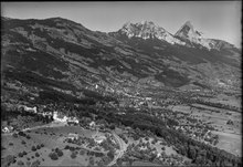
 Aerial view of the village of Steinerberg in summer 2018 |
|
| Location of the municipality | |
  |
|
Steinerberg is a municipality in the district of Schwyz in the canton of Schwyz in Switzerland .
coat of arms
The holy house is depicted on the coat of arms . Around the year 1400 it is said to have stood at the site of today's church, next to a linden tree.
geography
.
Steinerberg is located on a terrace of the Rossberg about 150 m above the Lauerzersee and the Schwyz valley basin.
economy
60% of the working population work outside the community. In addition, 40% find work in agriculture, woodworking companies, a cheese dairy and various small businesses.
traffic
Steiner Berg is on the road Arth - Pfäffikon SZ and has a station on the parallel path of the SOB .
history
Steinerberg developed as a resting place on the pilgrimage route to Einsiedeln Abbey .
As a separate parish, Steinerberg was separated from the Steinen parish in 1646.
The pilgrimages were very important in the 17th and 18th centuries. Several thousand pilgrims stopped in Steinerberg on special holidays.
Attractions

The parish church dedicated to Saint Anne dates from 1572. The cemetery chapel was built in 1684.
literature
- Linus Birchler : The art monuments of the canton Schwyz, Volume II: The districts Gersau, Küssnacht and Schwyz. Art historical overview. (= Swiss art monuments. Volume 2). Edited by the Society for Swiss Art History GSK. Bern 1930.
Web links
- Official website of the municipality of Steinerberg
- Andreas Meyerhans: Steinerberg. In: Historical Lexicon of Switzerland .
Individual evidence
- ↑ Permanent and non-permanent resident population by year, canton, district, municipality, population type and gender (permanent resident population). In: bfs. admin.ch . Federal Statistical Office (FSO), August 31, 2019, accessed on December 22, 2019 .
- ↑ Archived copy ( Memento of the original dated May 4, 2016 in the Internet Archive ) Info: The archive link was inserted automatically and has not yet been checked. Please check the original and archive link according to the instructions and then remove this notice.
- ↑ ortsnames.ch - search. Retrieved March 9, 2018 .
Alpthal |
Arth |
Illgau |
Ingenbohl |
Lauerz |
Morschach |
Muotathal |
Oberiberg |
Riemenstalden |
Rothenthurm |
Saddle |
Schwyz |
Stones |
Steinerberg |
Unteriberg
Former municipality: Iberg
Canton of Schwyz | Districts of Canton Schwyz | Municipalities in the canton of Schwyz