
Salhöhe
| Salhöhe | |||
|---|---|---|---|
 Salhöhe |
|||
| Compass direction | northwest | Southeast | |
| Pass height | 787 m above sea level M. | ||
| Canton | Solothurn | Aargau | |
| Valley locations | Kienberg | Erlinsbach | |
| expansion | Pass road | ||
| Mountains | law | ||
| profile | |||
| Ø pitch | 7.4% (238 m / 3.2 km) | 5.5% (392 m / 7.1 km) | |
| Max. Incline | 10.5% | 10.5% | |
| Map (Solothurn) | |||
|
|||
| Coordinates | 641 279 / 253295 | ||

The Salhöhe (also Saalhöhe ) is a pass in the Swiss Jura at an altitude of 787 m above sea level. M. and a maximum gradient of 10.5%. It connects the places Kienberg ( SO ) and Erlinsbach ( AG ). The Salhöhe forms the canton border between the cantons of Aargau and Solothurn. As the shortest connection between Aarau and Basel, this pass is only moderately traveled. From the top of the pass you have a wide view of the hills of the Aargau Jura. The Barmelweid Clinic is located in the immediate vicinity of the top of the pass .
Blocking point Erlinsbach
At the pass and south of the pass road at the Engnis von Breitmis in the municipality of Erlinsbach AG are the bunkers “Salhöhe” A 4540 ⊙ and “Breitmis” A 4539 ⊙ of the border brigade 5 from the Second World War .

Border stone from 1768, coat of arms of Front Austria (VO)
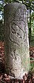
Border stone from 1768, Bernese coat of arms ( Unteraargau was part of Bern at that time)

Former “Salhöhe” bunker A 4540

Looking north


Web links
- Route profile from Erlinsbach
- Route profile from Kienberg
- Cornel Doswald: Salhöhe. In: Historical Lexicon of Switzerland .
Ächerli • Agites • Aiguillon • Albis • Albula • Balmberg • Benkerjoch • Bernina • Böhler • Bözberg • Breitehöchi • Brünig • Buechenegg • Bürersteig • Chall • Challhöchi Pass • Champex • Chasseral • Chatzenstrick • Chilchzimmersattel • Croix • Croix • Croix de Coeur • Eichhöhe • Étroits • Etzelpass • Flüela • Forclaz • Furka • Ghöch • Givrine • glass • Glaubenberg • Glaubenbielen • Gottschalkenberg • Grimsel • Grosse Scheidegg • Gr.St.Bernhard • Gurnigel • Haggenegg • Hahnenmoos • Heitersberg • Hilferen • Hirzel • Hirzel Höhi • Hulftegg • Ibergeregg • Jaman • Jaun • Julier • Kerenzerberg • Klausen • Kunkels • Lein • Lenzerheide • Livigno • Lukmanier • Maloja • Marchairuz • Mollendruz • Mont Crosin • Monte Ceneri • Mont d'Orzeires • Montvoie • Morgins • Mosses • Mutschellen • Neggia • Nufenen • Oberalp • upper Hauenstein • Oberricken • oven • Orn • Passwang • Pierre Pertuis • Pillon • Planches • Pontins • Pragel • edge crossing • Rangiers • rates • Rengg • crocheted • Roches • 'groups • R üsler • Saanenmöser • Salhöhe • San Bernardino • Sanetsch • Santelhöchi • Sattel • Sattelegg • Schafmatt • Schallenberg • Schelten • Schönau • Schufelberger Egg • Schwägalp • Schwarzenbühl • Siblingerhöhe • Simplon • Splügen • St. Anton • St. Gotthard • St. Luzisteig • Staffelegg • Stoss • Susten • Tourne • Tronc • Umbrail • Unterer Hauenstein • Front Höhi • Vue des Alpes • Wasserfluh • Weissenstein • Wildhaus • Wissegg • Wolfgang