
Erlinsbach AG
| AG is the abbreviation for the canton of Aargau in Switzerland and is used to avoid confusion with other entries of the name Erlinsbach . |
| Erlinsbach | |
|---|---|
 |
|
| State : |
|
| Canton : |
|
| District : | Aarau |
| BFS no. : | 4005 |
| Postal code : | 5018 |
| UN / LOCODE : | CH ERL |
| Coordinates : | 643 293 / 250433 |
| Height : | 420 m above sea level M. |
| Height range : | 369–908 m above sea level M. |
| Area : | 9.86 km² |
| Residents: | 4247 (December 31, 2019) |
| Population density : | 431 inhabitants per km² |
|
Proportion of foreigners : (residents without citizenship ) |
17.2% (December 31, 2019) |
| Website: | www.erlinsbach.ch |
 View of Erlinsbach AG (front) and Erlinsbach SO (back) |
|
| Location of the municipality | |
  |
|
Erlinsbach ( Swiss German : ˈæːrliʃˌpɑχ ) is a municipality in the Swiss canton of Aargau . It belongs to the Aarau district and is located on the Erzbach. This also forms the border to Erlinsbach SO in the canton of Solothurn .
geography

The northern boundary of the municipality extends along the main ridge of the Folded Jura , between the Wasserflue ( 866 m above sea level ) in the northeast and the Geissflue ( 963 m above sea level ) in the northwest. A secondary peak of the Geissflue, the Geissfluegrat, is the highest point in the canton of Aargau with a height of 908 meters. The Salhöhe lies between Wasserflue and Geissflue ; this 779 meter high pass crossing leads into the valley of the Bruggbach, a side valley of the Sissle .
The Erzbach rises south of the Salhöhe. Shortly after the confluence of the Zwiselbach, it squeezes through a narrow gorge between the Egg ( 776 m above sea level ) in the east and the Gugen ( 805 m above sea level ) in the west, which belong to the southernmost chain of the Folded Jura. In the further course the Erzbach forms the canton border for a length of more than four kilometers, until shortly before the confluence with the Aare . The Erzbach also separates the Aargau from the Solothurn Erlinsbach. Both communities together form a contiguous settlement with over 7500 inhabitants. Below the Wasserflue is the hamlet of Hard ( 675 m above sea level ), in the Erzbachklus the hamlet of Breitmis ( 475 m above sea level ).
The area of the municipality is 986 hectares , of which 531 hectares are covered with forest and 135 hectares are built over. The highest point is at 908 meters on the Geissfluegrat, the deepest at 370 meters in the southeast not far from the Aare. Neighboring communities are Oberhof in the north, Küttigen in the east, Aarau in the southeast, Erlinsbach SO in the west and Kienberg in the northwest.
history

Individual finds indicate a settlement of the Erzbach Valley during the Bronze Age and the rule of the Romans . Arnlesbah was first mentioned in a document in 1173 when Emperor Friedrich Barbarossa , who was then in Basel , confirmed his possessions to Beromünster Abbey . The place name goes back to the old high German Arinlinesbah and means "Bach des Arinlin". In the Middle Ages the Erzbach formed the border between the Frickgau and the Buchsgau . The Dinghof with curb and ban belonged to the Einsiedeln monastery and came into the possession of the Königsfelden monastery in 1349 . The lords of Kienberg , who were subordinate to the Habsburgs , exercised blood jurisdiction . In 1351 they also ceded their rights and property to Königsfelden. The village then belonged together with Biberstein and Küttigen to the office of Biberstein . The Edliswil settlement existed in today's municipality until the end of the 14th century, but it can no longer be localized.
Blood jurisdiction came to the city of Aarau in 1417 and to the Johanniterkommende in Biberstein in 1454 . The hamlet of Hard was built around 1500. In 1535 the city of Bern forced the Johanniter to sell their properties. In the meantime, Solothurn had acquired the western side of the valley. After Bern converted to the Reformation in 1528 , the Erzbach became a denominational border, as Solothurn remained Catholic. At that time Erlinsbach in Aargau did not have its own church. Since Bern had the right to appoint the pastor in the church in the Solothurn part of Erlinsbach, it tried after 1528 to appoint a Reformed pastor there. This led to protracted quarrels in the village, which could only be defused in 1565 when the reformed church was built. The Wyniger Treaty in 1665 regulated the final political division between Bern and Solothurn. Often Catholics and Reformed people spat at each other; This gave rise to the derisive name "Speuz" (spit) for Erlinsbach, which is still used today in everyday life and especially during Carnival .
In March 1798 the French took Switzerland, ousted the «Gracious Lords» of Bern and proclaimed the Helvetic Republic . Erlinsbach has been part of the canton of Aargau since then. In 1910 the lung sanatorium was opened on the Barmelweid , today's cantonal rehabilitation clinic. In the 1970s, the two cantons from Erlinsbach began to reduce their centuries-old contradictions and to cooperate more closely with one another. For example, a joint district school was opened in which school children from both communities are taught today. The fire brigade and civil defense are also run together.
Attractions

The Reformed Church Erlinsbach was built in 1565. The rectangular building with a cheese bite tower, built in the late Gothic style, stands on the southern slope of a hill in the middle of the cemetery. It is the first church in what is now the Canton of Aargau to be built without a choir . The church, which was enlarged in 1964/65, together with the rectory (1565) and the parish barn (1765) form an assembly.
coat of arms
The blazon of the municipal coat of arms reads: "Divided by a white oblique flow from yellow with a black oblique left bar and from blue with a five-pointed white star." The first municipal coat of arms showed a white sloping river in blue, above with three six-pointed white stars, below with a green three-mountain. From a heraldic point of view, this coat of arms was never convincing and was replaced in 1948 by the one used today. The sloping left bar is reminiscent of the Lords of Kienberg.
population
The population developed as follows:
| year | 1764 | 1803 | 1850 | 1900 | 1930 | 1950 | 1960 | 1970 | 1980 | 1990 | 2000 | 2010 |
| Residents | 433 | 523 | 930 | 1,161 | 1,383 | 1,679 | 1,940 | 2,690 | 3,046 | 3,281 | 3,286 | 3,580 |
On December 31, 2019, 4,247 people lived in Erlinsbach, the proportion of foreigners was 17.2%. In the 2015 census, 34.5% described themselves as Reformed and 26.4% as Roman Catholic ; 39.1% were non-denominational or of another faith. In the 2000 census, 90.3% stated German as their main language, 2.7% Serbo-Croatian , 1.7% Italian , 0.9% Albanian , 0.7% French and 0.6% Turkish .
Politics and law
The assembly of those entitled to vote, the municipal assembly , exercises legislative power. The executing authority is the five-member municipal council . He is elected by the people in the majority procedure, his term of office is four years. The parish council leads and represents the parish. To this end, it implements the resolutions of the municipal assembly and the tasks assigned to it by the canton. The Aarau District Court is the first instance responsible for legal disputes . Erlinsbach belongs to the Friedensrichterkreis I (Aarau).
economy

According to the company structure statistics (STATENT) collected in 2015, there are around 960 jobs in Erlinsbach, 6% of them in agriculture, 8% in industry and 86% in the service sector. Erlinsbach is a residential community with no major industrial operations, most of the workers commute to the neighboring town of Aarau . The community has a large number of farms, especially in the hamlet of Hard and on various outdoor farms. Viticulture is practiced on some hectares of the municipal area . The Barmelweid Clinic with 190 beds is located three kilometers north-west of the village center, at an altitude of 770 meters . Halfway there is the previously known Laurenzenbad spa , now a nursing home.
traffic
Erlinsbach is on Kantonsstrasse 536, the southern approach to Salhöhe , via which you can get to Frick and Gelterkinden . In the center of the village, Kantonsstrasse 266 branches off in the direction of Olten . The village is accessed by two bus lines: Line 2 of the bus operation Aarau operates from the Barmelweid about Erlinsbach and Aarau station by pipe , line 571 of the company BOGG reached via Niedergösgen or Lostorf the station Olten . The Postbus line from the direction of Gelterkinden ends at Salhöhe . At weekends, night buses run from Olten and Aarau to Erlinsbach.
education
Since 1979, the municipality has formed a special purpose association with Erlinsbach SO to operate a cross-border district school, in which all kindergartens, primary schools (up to and including 6th grade) and the upper classes of secondary and secondary schools are combined. This school is subject to Aargau law and teaching is based on the Aargau curriculum. The closest grammar schools are the Alte Kantonsschule and the Neue Kantonsschule , both in Aarau .
Personalities
- Johann Melchior Schuler (1779–1859), Protestant clergyman and local researcher
- Heinrich Bircher (1868–1927), entrepreneur
- Hans Roth (1913–2003), politician
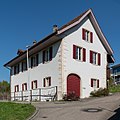
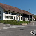
photos

Old parish hall
Former trot

Schoolhouse and gym
Former Wygärtli economy

Bluing school complex

The older part of the village of Erlinsbach AG


literature
- Alfred Lüthi: Erlinsbach. In: Historical Lexicon of Switzerland .
- Georg Boner : Erlinsbach: A look back at the past . Ed .: Erlinsbach municipal office. Erlinsbach 1973.
- Michael Stettler : The art monuments of the canton of Aargau . Ed .: Society for Swiss Art History . Volume I: The districts of Aarau, Kulm, Zofingen. Birkhäuser Verlag, Basel 1948, DNB 366495623 .
Web links
Individual evidence
- ↑ Cantonal population statistics 2019. Department of Finance and Resources, Statistics Aargau, March 30, 2020, accessed on April 2, 2019 .
- ↑ Cantonal population statistics 2019. Department of Finance and Resources, Statistics Aargau, March 30, 2020, accessed on April 2, 2019 .
- ↑ a b Beat Zehnder: The community names of the canton of Aargau . In: Historical Society of the Canton of Aargau (Ed.): Argovia . tape 100 . Verlag Sauerländer, Aarau 1991, ISBN 3-7941-3122-3 , p. 146-148 .
- ↑ a b National map of Switzerland, sheet 1089, Swisstopo.
- ↑ Standard area statistics - municipalities according to 4 main areas. Federal Statistical Office , November 26, 2018, accessed on May 18, 2019 .
- ^ Stettler: The art monuments of the Canton of Aargau, Volume I: The districts of Aarau, Kulm, Zofingen. S: 144-146
- ^ Joseph Galliker, Marcel Giger: Municipal coat of arms of the Canton of Aargau . Lehrmittelverlag des Kantons Aargau, book 2004, ISBN 3-906738-07-8 , p. 152 .
- ↑ Population development in the municipalities of the Canton of Aargau since 1850. (Excel) In: Eidg. Volkszählung 2000. Statistics Aargau, 2001, archived from the original on October 8, 2018 ; accessed on May 18, 2019 .
- ↑ Resident population by religious affiliation, 2015. (Excel) In: Population and Households, Community Tables 2015. Statistics Aargau, accessed on May 18, 2019 .
- ↑ Swiss Federal Census 2000: Economic resident population by main language as well as by districts and municipalities. (Excel) Statistics Aargau, archived from the original on August 10, 2018 ; accessed on May 18, 2019 .
- ↑ circles of justice of the peace. Canton of Aargau, accessed on June 21, 2019 .
- ↑ Statistics of the corporate structure (STATENT). (Excel, 157 kB) Statistics Aargau, 2016, accessed on May 18, 2019 .
Aarau | Biberstein | Box | Densbueren | Erlinsbach | Gränichen | Hirschthal | Küttigen | Mooing | Oberentfelden | Suhr | Unterentfelden
Former municipality: Rohr
Canton of Aargau | Districts of the Canton of Aargau | Municipalities in the Canton of Aargau