
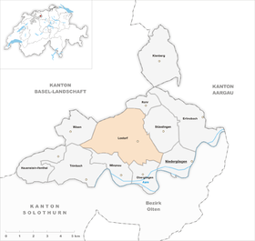
Lostorf
| Lostorf | |
|---|---|
 |
|
| State : |
|
| Canton : |
|
| District : | Gösgen |
| BFS no. : | 2493 |
| Postal code : | 4654 |
| Coordinates : | 638 614 / 248336 |
| Height : | 451 m above sea level M. |
| Height range : | 400–937 m above sea level M. |
| Area : | 13.25 km² |
| Residents: | 3952 (December 31, 2018) |
| Population density : | 298 inhabitants per km² |
| Website: | www.lostorf.ch |
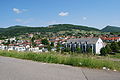
 Lostorf, seen from Engelberg |
|
| Location of the municipality | |
  |
|
Lostorf is a municipality in the district of Gösgen in the canton of Solothurn in Switzerland .
geography

Lostorf is 451 m above sea level. M. , 5 km northeast of the city of Olten (linear distance). The former Bachzeilendorf stretches on both sides of the Lostorfer Bach in a valley at the southern foot of the Jura , on the northern edge of the broad Aareniederung in the Solothurn Niederamt.
The area of the 13.3 km² municipal area covers a section of the southern slopes of the Jura and has a great variety of landscapes. The southern part of the municipality shows only slight differences in relief. It encompasses a small portion of the Aareniederung and the adjacent foothills of the Jura with the hills Balmis ( 483 m above sea level ), Eihübel ( 524 m above sea level ) and Buerfeld (up to 470 m above sea level ) with gentle opposite South sloping slopes. These are subdivided by the valleys of the Lostorf Bach and the Eibach , which step out into the Aare plain.
The chain of Dottenberg (on which the highest point of Lostorf lies at 938 m above sea level ) and Rebenflue ( 688 m above sea level ) rises above this Jura foot zone . Between these two heights is the breakthrough of the Lostorf village stream. The northern part of the municipality is located in the headwaters of the Dorfbach in a geologically complex structure and divided into individual scales section of the folded Jura . Due to a landslide in the Falkenstein area, which took place around a million years ago, the relief was further transformed. The northern municipal boundary runs along the Jura main ridge , the watershed between the Aare and Ergolz catchment areas , and extends from the Burgflue ( 935 m above sea level ) to the height of the Ban ( 910 m above sea level ). In the far west, the parish extends almost to the Froburg excursion restaurant. In 1997, 10% of the municipal area was accounted for by settlements, 50% for forests and woodlands and 40% for agriculture.
Lostorf includes the Mahren settlement ( 476 m above sea level ) in the valley of the Eibach at the southern foot of the Dottenberg, Bad Lostorf ( 524 m above sea level ) in the valley basin of the Lostorfer Bach behind the narrow point between Dottenberg and Rebenflue as well as numerous individual farms. Neighboring communities of Lostorf are Rohr (SO) , Stüsslingen , Niedergösgen , Obergösgen , Winznau , Trimbach and Wisen in the canton of Solothurn and Zeglingen in the canton of Basel-Landschaft .
population
With 3952 inhabitants (as of December 31, 2018) Lostorf is one of the medium-sized communities in the canton of Solothurn. 94.6% of the residents speak German, 1.2% speak Italian and 0.6% speak Serbo-Croatian (as of 2000). The population of Lostorf was 1096 inhabitants in 1850 and 1247 in 1900. In the course of the 20th century, the population rose slowly but steadily to 1,554 people until 1960. Since then, there has been a significant increase in population combined with a doubling of the population within 40 years.
politics
The municipal council for the 2013–2017 term of office consists of councilors from the following parties: FDP and SP two seats each , the CVP , SVP and the Free List one seat each.
Lostorf's partner municipality has been the German municipality of Rielasingen-Worblingen since 1998 .
economy
Up until the second half of the 20th century, Lostorf was predominantly an agricultural village. A nail forge and a plaster mill used to be in operation near Lostorf. The water power of the village stream was used to operate further mills. Mineralquelle Lostorf AG has existed since 1930, filling mineral water, manufacturing and selling sweet drinks.
Even today, arable farming , fruit growing , cattle breeding and dairy farming have a certain place in the income structure of the population. Further jobs are available in local small businesses and in the service sector. Since the 1970s, an industrial and commercial zone has been created on the southern edge of the village. Companies from the high-tech sector, metal processing and apparatus engineering have settled here. Other companies concentrate on the electrical industry, wood processing and the construction industry. In the last few decades the village has developed into a residential community thanks to its attractive location. Many employed people are therefore commuters who mainly work in the Olten and Aarau regions.
The Lostorf mineral spring, a gypsum and sulfur spring, has long been used as a thermal bath. After a fire in 1966, the thermal bath was rebuilt and used as a congress and seminar center. The hotel and the thermal bath have been closed since 2002.
Furthermore, part of the Heidental golf course is located in the Lostorf municipality.
traffic

The community is very well developed in terms of traffic, although it is located away from the major thoroughfares. The main access is from Obergösgen . Lostorf is connected to the public transport network by the BOGG bus line ( Busbetrieb Olten Gösgen Gäu ), which serves the route from Olten to Niedererlinsbach .
history
The municipality of Lostorf was already settled in Roman times; Traces of a Roman estate and a Roman control room were found above Bad Lostorf. The first written mention of the place took place in 1145 under the name Loztorf ; later the name Losdorf appeared (1265). The place name goes back to the Old High German personal name Hlodo or Lotto and thus means village of Hlodo / Lotto .
Since the Middle Ages Lostorf has belonged to the small rule Wartenfels in Buchsgau . The place belonged to the estate of the noble family von Wartenfels , which was under the sovereignty of the Habsburgs. In 1465 Lostorf and Wartenfels were bought by the city of Solothurn and subsequently assigned to the Bailiwick of Gösgen. Wartenfels Castle above the village served as the bailiff's seat. After the collapse of the Ancien Régime Lostorf (1798) was one during the Helvetic Republic to the administrative district of Solothurn and since the mediation from 1803 to Solothurn District Gösgen.
Attractions

- Wartenfels Castle , visible from afar, stands above the village on the eastward sloping spur of the Dottenberg , the core of which consists of a small castle from the 13th century. The castle got its present form in the 17th and 19th centuries when it was converted into a manor house in the Solothurn country house style. It also has a castle chapel with furnishings from around 1750 and a French garden.
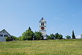
- The Roman Catholic Church of Saint Martin is located on a hill west of the village. It already existed in the Middle Ages, but received its current appearance as part of a fundamental redesign at the end of the 18th century. Another redesign and enlargement was made in 1936.
- The Evangelical Reformed Church was built from 1966 to 1967.
- In addition to these two churches, the chapel of Saints Philip and James (built in 1577) near Bad Lostorf and the Antonius chapel in Mahren, inaugurated in 1950, should be mentioned.
There is also a former rectory, a grain barn (both from the 17th century) and various characteristic farmhouses from the 17th to 19th centuries.
There is a traditional granary in the hamlet of Mahren.
Personalities
- Ramon Bischoff - musician, composer, radio host and former politician (* 1993)
photos
Catholic Church

Catholic Church, interior view

graveyard

reformed Church

Wartenfels Castle
View of the village from the Catholic Church
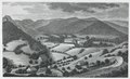
View from SE of Bad Lostorf and the Jura chain, aquatint, around 1830

Bad Lostorf, between 1820 and 1840


literature
- Hans Brunner: Lostorf. In: Historical Lexicon of Switzerland .
- Karin Zaugg: Wartenfels Castle near Lostorf . (Swiss Art Guide, No. 941, Series 95). Society for Swiss Art History GSK, Bern 2014, ISBN 978-3-03797-124-6 .
- Johann Heinrich Schmutziger: The Bad Lostorf . Aarau 1819, doi : 10.3931 / e-rara-24690
Web links
Individual evidence
- ↑ Permanent and non-permanent resident population by year, canton, district, municipality, population type and gender (permanent resident population). In: bfs. admin.ch . Federal Statistical Office (FSO), August 31, 2019, accessed on December 22, 2019 .
- ^ Municipal council elections 2013-2017 and factory building from April 14, 2013
- ^ Rielasingen-Worblingen: Partnerships
- ^ Chez Graber: Bachelor concert. Retrieved September 14, 2017 .
- ↑ Radio channel K: ear bar. (No longer available online.) Archived from the original on May 18, 2017 ; accessed on September 14, 2017 . Info: The archive link was inserted automatically and has not yet been checked. Please check the original and archive link according to the instructions and then remove this notice.
- ^ Smartvote: Ramon Bischoff. Retrieved September 14, 2017 .
Erlinsbach (SO) |
Hauenstein-Ifenthal |
Kienberg |
Lostorf |
Niedergösgen |
Obergösgen |
Pipe |
Stüsslingen |
Trimbach |
Winznau |
Wisen
Former communities: Niedererlinsbach | Obererlinsbach
Canton of Solothurn | Districts of the Canton of Solothurn | Municipalities of the Canton of Solothurn