
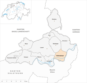
Niedergösgen
| Niedergösgen | |
|---|---|
 |
|
| State : |
|
| Canton : |
|
| District : | Gösgen |
| BFS no. : | 2495 |
| Postal code : | 5013 |
| Coordinates : | 641 874 / 247123 |
| Height : | 377 m above sea level M. |
| Height range : | 371-528 m above sea level M. |
| Area : | 4.32 km² |
| Residents: | 3865 (December 31, 2018) |
| Population density : | 895 inhabitants per km² |
| Website: | www.niedergoesgen.ch |
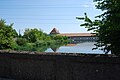
 View from the castle church to the nuclear power plant |
|
| Location of the municipality | |
  |
|
Niedergösgen is a municipality in the Gösgen district of the canton of Solothurn in Switzerland .
geography

Niedergösgen is 377 m above sea level. M. , about halfway between Olten and Aarau , 4.5 km southwest of the city of Aarau ( linear distance ). The village extends on the left bank of the Aare opposite Schönenwerd , at the southern foot of the Jura , in the far east of the Solothurn Mittelland .
The area of the 4.3 km² municipal area includes a section of the Solothurn Niederamt. The southern and eastern border is formed by the Aare, which flows here through a 1 to 1.5 km wide valley, which is narrowed at Niedergösgen by a spur made of Malm limestone (easily recognizable on the Schönenwerder valley side). Part of the water from the Aare between Olten and Winznau is diverted into an upstream channel and used in the Gösgen electricity plant (in combination with the Gösgen nuclear power plant ) to generate electricity. The eastern part of the so-called Schachen , the island between the original Aare and the canal, also belongs to Niedergösgen.
From the Aare, the municipality extends northward over the flat valley floor to the adjacent forest heights, a hilly zone at the foot of the Jura. It includes the Buerwald and the Usserholz ( 523 m above sea level ) as well as a part of the Herrenholz , where at 526 m above sea level. M. the highest point of Niedergösgen is reached, and drops steeply to the east to the Aare valley. In 1997, 29% of the municipal area was accounted for by settlements, 40% by forests and woodlands, 24% by agriculture and a little more than 7% was unproductive land.
Niedergösgen includes the hamlet of Mülidorf ( 392 m above sea level ), divided into two parts by the Aare Canal, as well as some individual farms. Neighboring communities of Niedergösgen are Erlinsbach SO , Schönenwerd , Gretzenbach , Däniken , Obergösgen , Lostorf and Stüsslingen .
population
With 3865 inhabitants (as of December 31, 2018) Niedergösgen is one of the medium-sized communities in the canton of Solothurn. 85.2% of the residents speak German, 4.6% Italian and 3.4% speak Serbo-Croatian (as of 2000). The population of Niedergösgen was 628 in 1850 and 1338 in 1900. In the course of the 20th century the population rose continuously to 3,637 until 1970. Since then, only minor fluctuations in population have been recorded.
economy
Until the beginning of the 20th century, Niedergösgen was a village dominated by agriculture . The water power of the Aare was used at Mülidorf very early (from the second half of the 16th century) to operate a paper mill, which was later replaced by a grain mill and finally a gypsum mill. Niedergösgen has been developing thanks to the Bally shoe factory in Schönenwerd since the end of the 19th century .
Today agriculture , animal husbandry and forestry have only a minor role in the livelihood structure of the population, the Bally shoe factory no longer exists. Numerous jobs are nonetheless available in trade and the service sector. Niedergösgen has mainly small and medium-sized companies in the construction, electricity, wood processing and mechanical workshops. In the last few decades the village has also developed into a residential community. Many employed people are commuters who mainly work in the Olten and Aarau regions.
The second pumping station of the nuclear power plant is located on the Aare Canal in the municipality of Niedergösgen. The municipality therefore also taxes KKG AG to a certain extent. This pumping station is important for the safety of the NPP: In the event of failure of the regular pumping station, for example in the event of an emergency power failure with the failure of the external power supply and self-consumption production, its diesel-driven pumps start up and ensure the water cooling of the emergency diesel generators in the plant, which in turn be able to perform the task of removing the decay heat from the reactor by driving electric pumps .
traffic
The community is accessible as follows: It is located on the connecting road from Olten along the northern bank of the Aare to Aarau . The nearest connection to the A1 motorway (Bern-Zurich) is around 7 km from the town center. Niedergösgen is connected to the public transport network by the BOGG bus line ( Busbetrieb Olten Gösgen Gäu ), which serves the route from Olten to Erlinsbach SO . The Schönenwerd train station on the Olten-Aarau railway line is also easily accessible.
history
The municipality of Niedergösgen was settled early on. Remains of a Roman estate were discovered, which was probably inhabited until the end of the 4th century AD. The older name was Bözach (first mentioned in 1294). At the beginning of the 14th century the name of the rule Gösgen passed to the village: Göskon inferior (1308), Gössikon (1347).
Around 1230, Gösgen Castle was built on the edge of the Aare valley near today's Niedergösgen , which became the new headquarters of the Gösgen rulership (previously in Obergösgen). When the barons of Gösgen died out, the castle and village of Niedergösgen passed to the Falkensteiners in 1383 , who also acquired the remaining parts of the rule in 1399. Niedergösgen was affected in the battles of the Confederates against the Habsburgs and in the conquest of Aargau (1415).
Since Thomas von Falkenstein, the last lord of Gösgen, acted against Solothurn and Bern in the Old Zurich War , they destroyed Niedergösgen Castle in 1444. Having got into serious financial difficulties, he had to sell the entire rule to Solothurn in 1458. Then Niedergösgen served as the bailiff's seat until the end of the Ancien Régime (1798).
Attractions

Niedergösgen's landmark is the castle church , which was built in 1904 in the neo- baroque style on the site of the former castle. The former castle tower, which was rebuilt and adapted to the new purposes, serves as the church tower. The building is under federal monument protection. Nearby is the Christian Catholic Church of St. Anton, which was built from 1659 to 1663 as a castle chapel. Several economic buildings, which today serve as the municipal administration, and parts of the former surrounding wall have been preserved. In Mülidorf there is a warehouse from the 17th century.
photos

Catholic Church, interior view

St. Anton's Christian Catholic Church

Methodist Church

Parish hall

Falkenstein Castle Inn
Olten-Gösgen electricity company

Niedergösgen seen from Bally Park

Castle, colored copper engraving, between 1754 and 1773


coat of arms
- Divided diagonally by red and white. The coat of arms is a reversal of the district coat of arms
Web links
- Official website of the Niedergösgen community
- Hans Brunner: Niedergösgen. In: Historical Lexicon of Switzerland .
- Castle world: Niedergösgen Castle (Falkenstein)
- Aerial photos of the village of Niedergösgen near Swisscastles
Individual evidence
- ↑ Permanent and non-permanent resident population by year, canton, district, municipality, population type and gender (permanent resident population). In: bfs. admin.ch . Federal Statistical Office (FSO), August 31, 2019, accessed on December 22, 2019 .
- ^ Hermann Ebenhöch: History of the paper mill in Niedergösgen . In: Yearbook for Solothurn History . tape 23 , 1950, pp. 115-142 , doi : 10.5169 / seals-323240 .
- ↑ Beat Hodler. Niedergösgen. A journey through history, 2008.
Erlinsbach (SO) |
Hauenstein-Ifenthal |
Kienberg |
Lostorf |
Niedergösgen |
Obergösgen |
Pipe |
Stüsslingen |
Trimbach |
Winznau |
Wisen
Former communities: Niedererlinsbach | Obererlinsbach
Canton of Solothurn | Districts of the Canton of Solothurn | Municipalities of the Canton of Solothurn