
Wisen
| Wisen | |
|---|---|
 |
|
| State : |
|
| Canton : |
|
| District : | Gösgen |
| BFS no. : | 2502 |
| Postal code : | 4634 |
| Coordinates : | 633 890 / 249388 |
| Height : | 682 m above sea level M. |
| Height range : | 611–991 m above sea level M. |
| Area : | 4.79 km² |
| Residents: | 417 (December 31, 2018) |
| Population density : | 87 inhabitants per km² |
| Website: | www.wisen.ch |
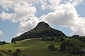
 Wisen, in the background the Wisnerberg, view from the south |
|
| Location of the municipality | |
  |
|
Wisen is a municipality in the Gösgen district in the canton of Solothurn in Switzerland .
geography
Wisen lies at 682 m above sea level. M. , 5 km north of the city of Olten (linear distance). The clustered village extends in the Solothurn Jura at the southern foot of the Wisenberg , on a saddle and in the valley of the Wisenbach to the east, near the lower Hauenstein pass . Besides Kienberg, Wisen is the only village in the Gösgen district north of the main ridge of the Jura.
The area of the 4.8 km² municipal area covers a section of the eastern Folded Jura . The larger eastern part of the village is located in the catchment area of the Wisenbachs , a source of Bach's north to Ergolz flowing Eibach . The northern boundary forms the wide ridge of the Wisenberg, on which at 990 m above sea level. M. the highest point of Wisen is reached. East of the village rises the striking rock formation of the Wisner Fluh , which belongs to the Flueberg ( 935 m above sea level ). In the east and south, the municipal boundary runs over the Jura main ridge, the watershed between the Aare in the south and the Ergolz in the north. It extends from the Burgflue (up to 930 m above sea level ) and the saddle of the Birmatt in the east over the height at Froburg ( 866 m above sea level ) to the Hangenmatt ( 804 m above sea level ) in the south. To the west, the municipality extends over the Wisner Sattel into the catchment area of the Homburg brook (left tributary of the Ergolz). In 1997, 6% of the municipal area was accounted for by settlements, 40% by forests and woodlands and 54% by agriculture.
Various individual farms belong to Wisen. Neighboring communities of Wisen are Lostorf , Trimbach and Hauenstein-Ifenthal in the canton of Solothurn and Läufelfingen , Häfelfingen and Zeglingen in the canton of Basel-Landschaft .
population
With 417 inhabitants (as of December 31, 2018), Wisen is one of the small communities in the canton of Solothurn. 97.9% of the residents speak German, 0.7% speak Romansh and 0.7% speak Dutch (as of 2000). The population of Wisen was 530 inhabitants in 1850, in 1900 only 346 inhabitants. In the course of the 20th century, the population continued to decrease to 285 people by 1970. Since then, the population has grown again significantly.
economy
Until the second half of the 20th century, Wisen was predominantly an agricultural village. Even today, livestock and dairy farming , arable farming and fruit growing (especially cherry trees) play an important role in the income structure of the population. Other jobs are available in local small businesses and in the service sector, including in a carpenter's workshop and photo studio. Hupp, a residential group of the social enterprise WG Treffpunkt from Trimbach, is in a promising location on the southwest slope of the Wisenberg. In the last few decades the village has developed into a residential community. Thanks to its relatively high location north of the main ridge of the Jura, Wisen has far fewer days of fog than the neighboring Aare valley. Many employed people are therefore commuters who mainly work in the Olten region, and sometimes also in the larger towns of the Ergolztal.
traffic
The community is located off the main thoroughfares on a connecting road from Untere Hauenstein to Gelterkinden . The village is connected to the public transport network by a BOGG bus line ( Busbetrieb Olten Gösgen Gäu ), which operates the route from Olten to Wisen.
history
The municipality of Wisen was already settled during the Bronze Age and the Roman Age. The place was first mentioned in a document in 1226 under its current name in a document from the Schöntal monastery. Later, the names Wison (1325), Wissen (1459) and Wysen (1526) appeared. Today the name is traced back to the Old High German personal name Wiso , the derivation from the Old High German word wisa (meadow) is rejected by modern name research.
Since the Middle Ages, Wisen has been under the rule of the Counts of Frohburg . In 1367 the village came to the Counts of Nidau, in 1375 as a Habsburg fiefdom to the Thiersteiners and in 1418 to the Falkensteiners, who owned the Gösgen rule. Wisen came to the city of Solothurn through purchase in 1458 and was now assigned to the Bailiwick of Gösgen. In the period that followed, until 1839 there were repeated disputes between Solothurn and Basel over the affiliation of the village; only since then has Wisen been legally assigned to the canton of Solothurn. After the collapse of the Ancien Régime (1798), Wisen belonged to the Solothurn administrative district during the Helvetic and from 1803 to the Gösgen district.
Attractions
A chapel had existed in Wisen since 1535, but it collapsed in 1763 and was rebuilt two years later. Since a renewed collapse of the chapel could not be ruled out, the church was replaced in 1837 by today's St. Joseph Church, a simple hall with a semicircular choir. It was elevated to a parish church in 1866 (previously the villagers were parish after Ifenthal). When the church tower was threatened with collapse again in 1925, a new tower was built on the south side of the church the following year. Popular hiking destinations just a few 100 meters beyond the municipal boundary are the Frohburg ruins and the observation tower on the Wisenberg .
photos
Wisner Flue

St. Joseph Church

Interior of the church

Lions

Sun

Cemetery and in the background the Wisner Flue


coat of arms
- Split three times by red and yellow, covered with a blue right-turned eagle with spread wings
The Wisner community coat of arms was introduced in 1925 and is derived from the Frohburg insignia. The Counts of Frohburg had an eagle in their shield, which was included in various municipal coats of arms in the region, including Waldenburg BL .
Movie
In 1980 the SF-DRS film Laziness or The Limping Alois was shot in Wisen .
Web links
- Official website of the municipality of Wisen
- Hans Brunner: Wisen. In: Historical Lexicon of Switzerland .
Individual evidence
- ↑ Permanent and non-permanent resident population by year, canton, district, municipality, population type and gender (permanent resident population). In: bfs. admin.ch . Federal Statistical Office (FSO), August 31, 2019, accessed on December 22, 2019 .
Erlinsbach (SO) |
Hauenstein-Ifenthal |
Kienberg |
Lostorf |
Niedergösgen |
Obergösgen |
Pipe |
Stüsslingen |
Trimbach |
Winznau |
Wisen
Former communities: Niedererlinsbach | Obererlinsbach
Canton of Solothurn | Districts of the Canton of Solothurn | Municipalities of the Canton of Solothurn