
Haefelfingen
| Haefelfingen | |
|---|---|
 |
|
| State : |
|
| Canton : |
|
| District : | Sissach |
| BFS no. : | 2847 |
| Postal code : | 4445 |
| Coordinates : | 632 331 / 251565 |
| Height : | 555 m above sea level M. |
| Height range : | 473–1001 m above sea level M. |
| Area : | 3.97 km² |
| Residents: | 250 (December 31, 2018) |
| Population density : | 63 inhabitants per km² |
| Website: | www.haefelfingen.ch |
 Häfelfingen and in the background Känerkinden |
|
| Location of the municipality | |
  |
|
Häfelfingen ( Swiss German : Häfelfinge ) is a municipality in the district of Sissach in the canton of Basel-Landschaft in Switzerland .
geography

Mountain village on the northwest slope of the Jura belonging to the Wisenberg , whose summit is 1002 m above sea level. M. is the highest point in the municipality. The Eimattbach , a tributary of the Homburgerbach , which in turn flows into the Ergolz, flows through the village .
The municipality of Häfelfingen borders in the north on Rümlingen , in the northeast on Rünenberg , in the east on Zeglingen , in the south on Wisen ( SO ), in the southwest on Läufelfingen and in the west on Buckten .
history
Häfelfingen was mentioned for the first time in 1358 as Hevelingen and indicates an early medieval clan settlement . The village originally belonged to the Counts of Frohburg and was later part of the Homburg rule . In 1305 the bishop and in 1400 the city of Basel acquired this dominion and with it the village. In 1798 Häfelfingen came to the Gelterkinden district and in 1814 to the Sissach district .
coat of arms
The village coat of arms was created in 1946 based on folk etymology based on the village name ( port "Topf"). It shows a black three-legged pot in a golden field under black horizontal stripes. The colors yellow-black are derived from the rule and the office of Homburg.
traffic
The village is connected by side streets with Rümlingen , Buckten and Läufelfingen and their train stations on the old Hauenstein line. During school hours , a Baselland Transport AG bus runs between Häfelfingen and Rümlingen.
Attractions
Spa
The mineral spa and spa hotel "Bad Ramsach" in the hamlet of Ramsach are recognized as a recognized Swiss spa.
photos

Traditional farmhouse in the village center

village street
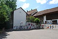
Schoolhouse and village square

school


literature
- Hans-Rudolf Heyer: The art monuments of the canton of Basel-Landschaft, Volume III: The district of Sissach. Edited by the Society for Swiss Art History GSK. Bern 1986 (Art Monuments of Switzerland, Volume 77). ISBN 3-7643-1796-5 . Pp. 80-83.
- s Baselbiet , Verlag des Kantons Basel-Landschaft, 1996, ISBN 3-85673-617-4
Web links
- Website of the municipality of Häfelfingen
- Thomas Schibler: Häfelfingen. In: Historical Lexicon of Switzerland .
Individual evidence
- ↑ Permanent and non-permanent resident population by year, canton, district, municipality, population type and gender (permanent resident population). In: bfs. admin.ch . Federal Statistical Office (FSO), August 31, 2019, accessed on December 22, 2019 .
- ↑ Bad Ramsach Mineral Spa on badi-info.ch
Anwil | Böckten | Buckten | Buus | Diepflingen | Gelterkinden | Häfelfingen | Inhibitions | Itingen | Känerkinden | Kilchberg | Läufelfingen | Maize language | Nut farm | Oltingen | Ormalingen | Rickenbach | Rothenfluh | Rümlingen | Rünenberg | Sissach | Tecknau | Tennis | Thuringia | Wenslingen | Wintersingen | Wittinsburg | Zeglingen | Touches
Canton of Basel-Country | Districts of the Canton of Basel-Landschaft | Municipalities in the canton of Basel-Landschaft