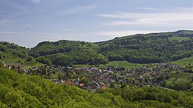
Laufelfingen
| Laufelfingen | |
|---|---|
| State : |
|
| Canton : |
|
| District : | Sissach |
| BFS no. : | 2852 |
| Postal code : | 4448 |
| Coordinates : | 631 499 / 249 441 |
| Height : | 560 m above sea level M. |
| Height range : | 491–968 m above sea level M. |
| Area : | 8.16 km² |
| Residents: | 1291 (December 31, 2018) |
| Population density : | 158 inhabitants per km² |
| Website: | www.laeufelfingen.ch |
|
Läufelfingen from the ruins of Homburg seen from |
|
| Location of the municipality | |
Läufelfingen is a municipality in the district of Sissach in the canton of Basel-Landschaft in Switzerland .
geography

Läufelfingen is at the top of the Homburgertal, embedded in the hills of the Jura in Basel, at the foot of the Lower Hauenstein Pass on the border with the Canton of Solothurn. It is 10 km from Olten , 17 km from Liestal and 35 km from Basel . It is located on the Sissach – Olten line, the S9 of the Basel Regional S-Bahn, also known as Läufelfingerli . The SBB station is 556 m above sea level. M., the highest point in the municipality is at the Schmutzbergfluh (980 m) and the lowest at the Homburgerbach on the border with the neighboring village of Buckten. Läufelfingen is located in the middle of the local recreation and hiking area Wisenberg -Bad Ramsach- Belchenflue . The community borders on Känerkinden in the north-west, Buckten in the north and Häfelfingen in the north-east, Wisen ( SO ) in the east, Hauenstein-Ifenthal ( SO ) in the south, Eptingen in the south-west and Diegten in the west .
history
Middle Ages and early modern times
Leinvolvingen was first mentioned in a document in 1226. But the village is a lot older. The place name with the ending -ingen refers to the time of the first Alemannic settlements, which emerged south of the Rhine from the 7th century. In 2002, during construction work in the basement of the Läufelfingen rectory, the remains of an early medieval cemetery were found, as well as rubble from Roman times. It can therefore be assumed that the first church with a cemetery was built in the ruins of an abandoned Roman estate around the 8th century. The associated early medieval village was not built next to the church, but down in the valley floor.
Various archaeological finds (e.g. coins) and field names bear witness to the fact that the area around the Untere Hauenstein was already explored in Roman times . Traces of cart tracks in the creek bed of the Homburgerbach (below the carpenter's shop at the northern end of the village) and on the Alte Hauensteinstrasse (in the forest just before the top of the pass) show that the pass traffic on the Untere Hauenstein is ancient. However, whether the cart tracks come from Roman times or from the Middle Ages is a matter of dispute among historians.
In the High Middle Ages the village belonged to the Lords of Frohburg . They resided on the Frohburg above Trimbach , which was built in the 10th century, fell into disrepair from the 14th century and can now be reached by car from the village of Hauenstein . A Frohburger scion, Count Hermann IV, had a new castle built at the narrowest point of the valley between Buckten and Läufelfingen in 1240 - to monitor the flourishing north-south trade from Basel via the Lower Hauenstein towards Gotthard and Italy. Count Hermann named the newly built castle Neu-Homberg in honor of his wife, who was the heir to Count von (Alt-) Homberg in the Fricktal in Aargau. 60 years later, Count Hermann's grandson - his name was also Hermann and was in financial difficulties - sold the castle and the associated villages, including Läufelfingen, to the Bishop of Basel. But this also came into financial difficulties, and so around 1400 the city of Basel bought the rights to rule over the Homburgertal and thus also over Läufelfingen.
In the peasant unrest of 1653 , in which the rural population revolted against ever more oppressive burdens and requirements from the city authorities, Uli Gysin from Hof Halden in Läufelfingen stood out as a spokesman. He was executed in Basel on July 14, 1653, together with six other representatives of the people, all of whom were family fathers and honorable citizens of their communities. The rule of the city of Basel lasted until 1832, when Läufelfingen became a sovereign municipality in the newly founded canton of Basel-Landschaft.
Recent history
From 1827 to 1830 the new pass road was built over the Hauenstein , which with its sweeping bends replaced the old road, which was bumpy, steep and partly within the creek beds. The railway age soon dawned and competed with pass traffic. In 1858, the Hauenstein summit tunnel on the Centralbahn line from Basel to Olten was opened. At that time, this tunnel between Läufelfingen and Trimbach was the longest tunnel in Europe with its 2495 meters. During the tunnel construction there was a fire disaster that killed 63 workers.
Thanks to the railway connection, industry and commerce developed in Läufelfingen. The mining and processing of gypsum (Gips-Union, until 1981) as well as cement products and other building materials (Gebr. Kohler, until 2010) became the most important. The local culture and museum association is planning to expand the so-called sand mill at the quarry on Hauensteinstrasse into a museum that documents the industrial history of the village.
coat of arms
In the 20th century, the community took over the coat of arms of the former Counts of Homburg: two black eagles with red fangs and beaks floating on top of each other on a golden background.
population
- Proportion of foreigners : 11%.
- Religion : 59% Reformed , 18% Roman Catholic
traffic
Due to the low level of cost coverage of the Läufelfingerli , a switch to bus operation was considered several times, including in 2005. However, after massive protests against a corresponding government decision, the Basel Parliament (the district administrator ) decided in November 2006 with a large majority to continue rail operations. In 2008, the district administrator approved the expansion of the stops along the S9 according to the contemporary S-Bahn standard (carried out in 2010).
In 2011, the government proposed that the S9 timetable be thinned out by a third in order to save money, i.e. no longer ensuring the hourly service. After again violent reactions, the district administrator rejected this austerity measure in May 2012. The continuation of rail operations in the current framework appears to be secured at least until 2017. In the referendum vote on November 26, 2017, this consideration was rejected anyway: Around 65 percent of the electorate said "No" to the closure of the "Läufelfingerli",
Say
A legend claims that you can sometimes see a white woman - the tunnel ghost - riding along on the train near Läufelfingen . Another story tells of the souls of the dead tunnel workers who can be heard screaming when the Hauensteiner wind blows violently.
Attractions
- St. Peter and Paul: The medieval church houses three modern leaded glass windows by Walter Eglin and, together with the parish and Sigrist house, forms an ensemble above the village center.
- The restored ruins of Homburg .
- Animal cemetery at Wisenberg : The first animal cemetery in Switzerland (founded in 2001), located in the countryside on the site of a former plaster of paris factory.
Personalities
- Bruno Balscheit (1910–1993), reformed parish priest and professor at the University of Basel
photos
Engraving from 1756 by David Herrliberger
Engraving from 1756 by David Herrliberger
Engraving from 1758 by David Herrliberger
literature
- Hans-Rudolf Heyer: The art monuments of the canton of Basel-Landschaft, Volume III: The district of Sissach. (= Art Monuments of Switzerland , Volume 77.) Edited by the Society for Swiss Art History GSK. Bern 1986, ISBN 3-7643-1796-5 . Pp. 118-138.
Web links
- Official website of the municipality of Läufelfingen
- Antonia Schmidlin: Läufelfingen. In: Historical Lexicon of Switzerland .
Individual evidence
- ↑ Permanent and non-permanent resident population by year, canton, district, municipality, population type and gender (permanent resident population). In: bfs. admin.ch . Federal Statistical Office (FSO), August 31, 2019, accessed on December 22, 2019 .
- ^ Report of the building and planning commission, November 7, 2006
- ^ Minutes of the district council meeting on November 16, 2006


