
Känerkinden
| Känerkinden | |
|---|---|
 |
|
| State : |
|
| Canton : |
|
| District : | Sissach |
| BFS no. : | 2850 |
| Postal code : | 4447 |
| Coordinates : | 629 952 / 251279 |
| Height : | 554 m above sea level M. |
| Height range : | 520–804 m above sea level M. |
| Area : | 1.48 km² |
| Residents: | 528 (December 31, 2018) |
| Population density : | 357 inhabitants per km² |
| Website: | www.kaenerkinden.ch |
 Känerkinden in the center of the picture, seen from the Homburg ruins . In the foreground parts of Buckten |
|
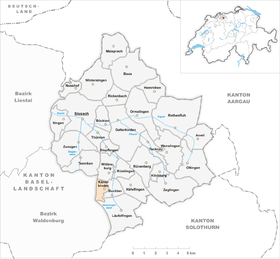
| Location of the municipality | |
  |
|
Känerkinden is a municipality in the district of Sissach in the canton of Basel-Landschaft in Switzerland .
geography
Känerkinden lies in a shallow hollow on a foothill of the Table Jura between the Diegter and Homberg valleys.
The municipality of Känerkinden borders in the north on Wittinsburg , in the east on Buckten , in the south on Läufelfingen and in the west on Diegten .
history
The first written mention of Känderkinden comes from the year 1359 as Kennichingen .
In the Middle Ages, Känerkinden was a village under the Homburg rulership, which became the property of the Bishop of Basel in 1305. Around 1400 the entire Homburg domain was acquired by the city of Basel . Känderkinden has been part of the Sissach district since 1814, with which the village became part of the newly founded canton of Basel-Landschaft in 1833.
traffic
Känerkinden is located on the cantonal road between Buckten and Diegten. The village is connected to the public transport network by bus line 108 to Sissach .
The next motorway connection to the N2 is 2 km west of the village near Diegten.
Attractions

Walter Eglin Museum

Church of the Chrischona Parish

Parish hall

Residential house in the village center


literature
- Hans-Rudolf Heyer: The art monuments of the canton of Basel-Landschaft, Volume III: The district of Sissach. Edited by the Society for Swiss Art History GSK. Bern 1986 (Art Monuments of Switzerland, Volume 77). ISBN 3-7643-1796-5 . Pp. 96-98.
Web links
- Official website of the municipality of Känerkinden
- Dominik Wunderlin: Känerkinden. In: Historical Lexicon of Switzerland .
Individual evidence
- ↑ Permanent and non-permanent resident population by year, canton, district, municipality, population type and gender (permanent resident population). In: bfs. admin.ch . Federal Statistical Office (FSO), August 31, 2019, accessed on December 22, 2019 .
Anwil | Böckten | Buckten | Buus | Diepflingen | Gelterkinden | Häfelfingen | Inhibitions | Itingen | Känerkinden | Kilchberg | Läufelfingen | Maize language | Nut farm | Oltingen | Ormalingen | Rickenbach | Rothenfluh | Rümlingen | Rünenberg | Sissach | Tecknau | Tennis | Thuringia | Wenslingen | Wintersingen | Wittinsburg | Zeglingen | Touches
Canton of Basel-Country | Districts of the Canton of Basel-Landschaft | Municipalities in the canton of Basel-Landschaft