
Winznau
| Winznau | |
|---|---|
 |
|
| State : |
|
| Canton : |
|
| District : | Gösgen |
| BFS no. : | 2501 |
| Postal code : | 4652 |
| UN / LOCODE : | CH WZA |
| Coordinates : | 637369 / 246228 |
| Height : | 403 m above sea level M. |
| Height range : | 379–852 m above sea level M. |
| Area : | 3.94 km² |
| Residents: | 1919 (December 31, 2018) |
| Population density : | 487 inhabitants per km² |
| Website: | www.winznau.ch |
 Winznau |
|
| Location of the municipality | |
  |
|
Winznau is a municipality in the district of Gösgen in the canton of Solothurn in Switzerland .
geography
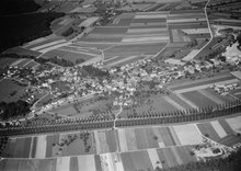
Winznau is 403 m above sea level. M. , between Olten and Aarau , 2.5 km east-northeast of the city of Olten (linear distance). The village extends on the northern edge of the wide lowlands of the Aare valley , at the southern foot of the Jura , in the east of the Solothurn Mittelland .
The area of the 4.0 km² municipal area comprises a section of the Solothurn Niederamt. The southern border runs along the old Aare. Much of the water from the Aare is diverted west of Winznau into a side canal (Gösger Canal) and used by the Olten-Gösgen power station near Niedergösgen . The western part of the so-called Schachen , the island between the original Aare and the Gösger Canal, also belongs to Winznau. From the Aare, the municipality extends northward over the valley and the adjoining gravel terraces to the Tägermoos (plain south of Lostorf) and the Balmis ( 483 m above sea level ).
In a narrow strip, the municipality extends to the northwest and includes the valley of the village stream. It extends over the southern foothills of the Jura ( Chöpfli , 507 m above sea level , and Stellichopf , 667 m above sea level ), each of which slopes steeply towards the Aare valley near Olten with rocky edges. In the extreme northwest, on the Sonnenweide on the southern slope of the Dottenberg at 851 m above sea level. M. reached the highest point of Winznau. In 1997, 17% of the municipal area was in settlements, 42% in forests and woodlands, 37% in agriculture and a little less than 4% was unproductive land.
Various individual farms belong to Winznau. Neighboring communities of Winznau are Lostorf , Obergösgen , Dulliken , Olten and Trimbach .
population
With 1919 inhabitants (as of December 31, 2018), Winznau is one of the medium-sized communities in the canton of Solothurn. 93.8% of the residents speak German, 1.6% speak Albanian and 1.5% speak Italian (as of 2000). The population of Winznau was 350 in 1850, and 392 in 1900. In the course of the 20th century, the population grew steadily (1263 inhabitants were counted in 1970).
economy
Until the second half of the 20th century, Winznau was predominantly an agricultural village. Even today, arable farming , fruit growing and animal husbandry, as well as forestry, have a certain place in the income structure of the population. Further jobs are available in local small businesses and in the service sector. Smaller industrial and commercial zones emerged mainly on the eastern edge of the village and on the Schachen. Today in Winznau there are companies in the construction and transport industry, horticulture, mechanical workshops, a sandblasting plant and carpentry shops. The regional sewage treatment plant of the waste water region Olten (with approx. 50,000 people connected) is also located between the Gösger Canal and the Aare, in the Winznau municipality. In the last few decades the village has developed into a residential community. Many employed people are therefore commuters who mainly work in the Olten and Aarau regions.
traffic
The community is very well developed in terms of transport. It is located on the connecting road from Olten along the northern bank of the Aare via Niedergösgen to Aarau . The closest connection to the A1 motorway ( Bern - Zurich ) is around 8 km from the town center. Winznau is connected to the public transport network by a BOGG bus line ( Busbetrieb Olten Gösgen Gäu ), which operates the route from Olten to Erlinsbach SO .
history
Winznau can look back on a very long settlement tradition. The municipality was already inhabited during the Paleolithic more than 10,000 years ago , particularly because of the occurrence of flint from which early tools were made . Various tool finds date from this time. Iron Age burial mounds in the Hardwald indicate a settlement by the Celts . Small traces of settlement have also been found from Roman times .
The place was first mentioned in a document in 1266 under the name Winzenowa . Later the names Winznow (1308) and Wintznouwe (1360) appeared. The place name is made up of the Old High German personal name Win (i) zo and the word owa (Au) and therefore means something like Au des Win (i) zo .
Since the Middle Ages, Winznau has been under the Buchsgau administered by the Counts of Frohburg . In the 13th century, the ministerial family of the Knights of Winznau is also proven. In 1367 the village came to the Counts of Nidau, in 1375 as a Habsburg fiefdom to the Thiersteiners and in 1418 to the Falkensteiners, who owned the Gösgen rule. Winznau came to the city of Solothurn through purchase in 1458 and was now assigned to the Bailiwick of Gösgen and the Dulliken district court. After the collapse of the Ancien Régime (1798), Winznau belonged to the Solothurn administrative district during the Helvetic and from 1803 to the Gösgen district.
Since the Aare caused major floods each time it was flooded, the lower terrace in the area of Winznau could not be settled. With the construction of the Gösger Canal in the period from 1913 to 1917, the Aare was regulated, which resulted in a significant change in the landscape. Large parts of the floodplain were drained and new cultivated land and settlement areas were gained.
Attractions
In the Middle Ages, the Sankt Johann Baptista chapel stood in Winznau, which was destroyed during the turmoil of the Reformation and was not rebuilt until 1644. This chapel was elevated to the parish church of the parish of Winznau in 1887 (before that, the Winznau residents were parishes first to Lostorf, then to Obergösgen). In 1924 the new parish church of St. Karl Borromeo was inaugurated, which was built in the neo-baroque style.
photos

Tower of the Church of Saint Charles Borromeo
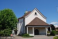
Church of Saint Charles Borromeo
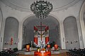
Church of Saint Charles Borromeo, interior view

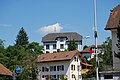
Crossing in the village center

View from Dorfstrasse to the south
school
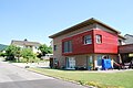
Wooden house

Winznau weir


coat of arms
- Yellow five-leaf green vine branch with two green tendrils
The coat of arms is based on the erroneously assumed origin of the place name of vintner
Web links
- Official website of the municipality of Winznau
- Hans Brunner: Winznau. In: Historical Lexicon of Switzerland .
Individual evidence
- ↑ Permanent and non-permanent resident population by year, canton, district, municipality, population type and gender (permanent resident population). In: bfs. admin.ch . Federal Statistical Office (FSO), August 31, 2019, accessed on December 22, 2019 .
Erlinsbach (SO) |
Hauenstein-Ifenthal |
Kienberg |
Lostorf |
Niedergösgen |
Obergösgen |
Pipe |
Stüsslingen |
Trimbach |
Winznau |
Wisen
Former communities: Niedererlinsbach | Obererlinsbach
Canton of Solothurn | Districts of the Canton of Solothurn | Municipalities of the Canton of Solothurn