
Dulliken
| Dulliken | |
|---|---|
 |
|
| State : |
|
| Canton : |
|
| District : | Olten |
| BFS no. : | 2573 |
| Postal code : | 4657 |
| UN / LOCODE : | CH DIN |
| Coordinates : | 638 323 / 244 782 |
| Height : | 436 m above sea level M. |
| Height range : | 379–706 m above sea level M. |
| Area : | 6.04 km² |
| Residents: | 5048 (December 31, 2018) |
| Population density : | 836 inhabitants per km² |
| Website: | www.dulliken.ch |
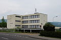
 Center of Dulliken, in the background the tower of the Catholic Church |
|
| Location of the municipality | |
  |
|
Dulliken is a municipality in the Olten district in the canton of Solothurn in Switzerland .
geography

Dulliken is 394 m above sea level. M. , 3 km east of the district capital Olten (linear distance). The village extends on the high terrace on the southern edge of the Aareniederung , at the foot of the Engelberg range , at the southern foot of the Jura in the Solothurn Niederamt.
The area of the 6.0 km² municipality covers a section of the Aare valley east of Olten in the eastern Solothurn Mittelland . The northern municipal boundary runs partly along the course of the Aare river, partly on the adjacent lower terrace to the south. From here, the municipality extends southward over the 800 m wide gravel terrace of Dulliken and the anticline of the Engelberg, which is a fold in front of the Jura south of the Aare. The entire plateau of Engelberg belongs to Dulliken, the southern border is on the edge of the steep drop towards the Safenwil valley. The lowest point in the community is on the Aare at 386 m above sea level. M. , while the highest elevation with 702 m above sea level. M. is located on the ridge of the Engelberg. In 1997, 25% of the municipal area was in settlements, 35% in forests and woodlands, 39% in agriculture and a little less than 1% was unproductive land.
The former hamlet of Leimgruben ( 448 m above sea level ), slightly elevated on the lower northern slope of Engelberg and the hamlet of Engelberg ( 670 m above sea level ) on the plateau of the mountain of the same name, belong to Dulliken . In contrast, Schachen, located south of the Aare, is part of the municipality of Obergösgen. Neighboring communities of Dulliken are Starrkirch-Wil , Olten , Winznau , Obergösgen , Däniken and Walterswil in the canton of Solothurn and Oftringen in the canton of Aargau . The settlement area of Dulliken has now merged seamlessly with that of Starrkirch-Wil.
population
With 5048 inhabitants (as of December 31, 2018) Dulliken is one of the medium-sized communities in the canton of Solothurn. 79.2% of the residents speak German, 9.2% Italian and 4.0% speak Turkish (as of 2000). The population of Dulliken was 671 in 1850 and 828 in 1900. In the course of the 20th century, the population rose to 4,526 by 1970, with particularly large growth rates being recorded in the 1950s and 1960s. Since 1970 there have been only minor fluctuations in the population.
Sons and daughters of the church
- Peter V. Kunz (* 1965), business lawyer and former politician
economy
Until the 20th century, Dulliken was predominantly an agricultural village. Since the first half of the 20th century, companies in the shoe industry, metal construction and construction began to settle here.
Today agriculture , animal husbandry and forestry have only a marginal role in the employment structure of the population. Numerous other jobs are available in the industrial sector and in the service sector. Larger commercial and industrial zones are located on the level between the railway line and the Aare. Various companies in the construction and transport industry, mechanical engineering, metal construction, body construction, electrical engineering, advertising, wood processing, electronic industry, precision engineering workshops and trading companies are represented in the municipality today. A gravel pit is being exploited east of the village.
Dulliken has been the location of a regional retirement and nursing home since 1979. From 1968 to 2001 the Franziskushaus education center of the Swiss Capuchin Order was located in the community. In the last few decades the village has developed into a residential community. Many employed people are therefore commuters who mainly work in the Olten and Aarau regions.
traffic
The community has good transport connections. It is located on the main road 5 from Olten to Aarau . The closest connection to the A1 motorway (Bern-Zurich) is around 8 km from the town center. On June 9, 1856, the railway line from Olten to Aarau was put into operation. The Dulliken station was not set up until 1899. The BOGG bus routes ( Busbetrieb Olten Gösgen Gäu ), which serve the routes from Trimbach via Olten to Dulliken and from Dulliken to Obergösgen, ensure the fine distribution of public transport .
history
The municipality of Dulliken was populated very early. Traces of settlement from the Neolithic era were found on the Engelberg, as well as the remains of a Roman estate on the Wilberg, which was probably destroyed during the invasions of the Alemanni around 260 AD.
The first written mention of the place took place in 893 under the name Tullinchoua , 924 as Tullinchova . Later, the names Tullichon (1173), Tullikon (1294), Tullenkon (1317), Tulliken (1412) and Dullicken (1525) appeared. The place name goes back to the Old High German personal name Tullo . With the name ending -iken (actually a contraction of -igkofen ) it means something like the courts of the people of Tullo , whereby so-called repatriate farms are meant.
In the Middle Ages , Dulliken was initially part of the Werderamt in Buchsgau , then the lower jurisdiction came to the Schönenwerd monastery. The village was later subordinated to the barons of Gösgen-Falkenstein before it was acquired by Solothurn in 1458. Dulliken was incorporated into the Bailiwick of Gösgen and in 1627 assigned to the newly founded Schultheissenamt Olten. After the collapse of the Ancien Régime (1798), Dulliken belonged to the Solothurn administrative district during the Helvetic and from 1803 to the Olten district.
During the 19th century, Dulliken was a poor community. Some of the residents went to work in Olten and others in Schönenwerd ( Bally shoe factory ). Industrialization did not begin in Dulliken until after 1930 with the establishment of a radiator factory and the Hug & Co. AG shoe factory, which for a long time was the village's most important employer. Dulliken was badly affected by the economic crisis during the 1970s, as numerous jobs were lost. Since then, the industry has diversified and new companies from various industries have settled in the community.
Ecclesiastically, Dulliken was affiliated with the parish of Starrkirch. Since the Middle Ages it has had its own house of worship, the St. Nicholas Chapel, which was demolished in 1887. The Kulturkampf led to the split of the Catholic parish Starrkirch-Dulliken in 1872 into a Christian Catholic and a Roman Catholic parish. The Christ Catholics continue to attend the service in Starrkirch. The church of Sankt Wendelin in Dulliken was inaugurated in 1876 for residents of the Roman Catholic faith, which was replaced by a modern new building in 1972. The reformed Zwingli Church was consecrated in 1961.
Attractions
On the Engelberg there is a steel framework built in 1974, 110.6 meter high transmission tower.

Bells ringing at the Zwingli Church in Dulliken

Engelberg with transmission tower

View of the Gösgen nuclear power plant from the slope of Engelberg above Dulliken
Neumatt Schoolhouse
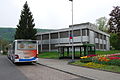
Dulliken center

Re 6/6 No. 11631 "Dulliken"

_118.JPG)


_Nr._11631_%22Dulliken%22_in_Bellinzona.jpg)
coat of arms
- Black, right-turned jackdaw standing in yellow on a green garland
The coat of arms has its origin in the erroneous derivation of the place name from the animal name jackdaw.
partnership
-
 Ammerndorf in Bavaria since 1996
Web links
- Official website of the municipality of Dulliken
- Hans Brunner: Dulliken. In: Historical Lexicon of Switzerland .
Individual evidence
- ↑ Permanent and non-permanent resident population by year, canton, district, municipality, population type and gender (permanent resident population). In: bfs. admin.ch . Federal Statistical Office (FSO), August 31, 2019, accessed on December 22, 2019 .
- ↑ BOGG - BUSBETRIEB Olten Gösgen Gäu AG - Line 502. Accessed on August 17, 2020 .
Boningen |
Däniken |
Dulliken |
Eppenberg-Wöschnau |
Fulenbach |
Gretzenbach |
Gunzgen |
Hägendorf |
Kappel |
Olten |
Rickenbach |
Schönenwerd |
Starrkirch-Wil |
Walterswil |
Wangen near Olten
Former parishes: Grod
Canton of Solothurn | Districts of the Canton of Solothurn | Municipalities of the Canton of Solothurn