
Eppenberg-Wöschnau
| Eppenberg-Wöschnau | |
|---|---|
 |
|
| State : |
|
| Canton : |
|
| District : | Olten |
| BFS no. : | 2574 |
| Postal code : | 5012 |
| Coordinates : | 644 284 / 247511 |
| Height : | 459 m above sea level M. |
| Height range : | 363–491 m above sea level M. |
| Area : | 1.81 km² |
| Residents: | 330 (December 31, 2018) |
| Population density : | 182 inhabitants per km² |
| Website: | www.eppenberg-woeschnau.ch |
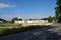
 Eppenberg |
|
| Location of the municipality | |
  |
|
Eppenberg-Wöschnau is a municipality in the Olten district in the canton of Solothurn in Switzerland .
geography

Eppenberg-Wöschnau is located around 2 km southwest of the city of Aarau (linear distance). Wöschnau extends to 379 m above sea level. M. on the southern edge of the Aare valley on the gravel terrace and at the foot of the Buechholz , while Eppenberg on a gently sloping eastward slope at 459 m above sea level. M. is located in a clearing island on the range of hills between the Aare valley and the Suhrental .
The area of the 1.9 km² municipal area covers a section of the Swiss Central Plateau in the far east of the canton of Solothurn. The northern border runs along the former Aare river, while the main part of the water is directed further north via a side canal to a hydroelectric power station. From the Aare the municipality extends southward over the valley low ( Schachen ) and onto the adjacent range of hills of the Buechholz, which slopes sharply towards the Aare valley with a rocky edge and a steep slope. At the height west of Eppenberg is 491 m above sea level. M. reached the highest point of the municipality. The southern part of the municipality includes the clearing island of Eppenberg, the slope of which slopes gently to the east towards the Roggenhusertäli . The Roggenhuserbach , a short right side stream of the Aare, forms the eastern border for long stretches. In 1997, 16% of the municipal area was in settlements, 44% in forests and woodlands, 38% in agriculture and a little more than 2% was unproductive land.
The double community consists of the districts Eppenberg and Wöschnau and an industrial estate in Schachen. Neighboring communities of Eppenberg-Wöschnau are Schönenwerd and Erlinsbach in the canton of Solothurn and Aarau and Unterentfelden in the canton of Aargau .
population
With 330 inhabitants (as of December 31, 2018), Eppenberg-Wöschnau is one of the small communities in the canton of Solothurn. 81.0% of the residents speak German, 4.8% speak Serbo-Croatian and 4.2% speak Italian (as of 2000). The population of Eppenberg-Wöschnau was 183 inhabitants in 1850 and 266 in 1900. In the course of the 20th century, the population rose to 439 people by 1970. Since then there has been a clear downward trend, with the population decline mainly due to Wöschnau.
economy
Until well into the 20th century, Eppenberg-Wöschnau was predominantly an agricultural community. Today agriculture and livestock farming have only a minor role in the income structure of the population. Further jobs are available in local small businesses and in the service sector. In the Aare valley near Wöschnau, construction companies and a carpentry shop have set up shop. Part of the Aarauer Reitbahn im Schachen is also located in the municipality. In the last few decades, Eppenberg in particular has developed into a residential community. Many employed people are therefore commuters who work mainly in the Aarau and Olten regions.
traffic
The community is very well developed in terms of traffic. Wöschnau is located on the main road 5 from Olten to Aarau , while Eppenberg is easy to reach off the major thoroughfares from Schönenwerd or Wöschnau. The closest connection to the A1 motorway (Bern-Zurich) is around 6 km from Eppenberg. Wöschnau is connected to the public transport network (Eppenberg, on the other hand, is not) through a bus line operated by the AAR bus + bahn transport company , which operates the route from Aarau to Gretzenbach .
In 2015, the construction of the Eppenberg tunnel began , which will strengthen the Olten-Aarau railway line. The construction company Huber from Eppenberg-Wöschnau has received an order for this construction site.
history
The municipality of Eppenberg-Wöschnau was settled early on. On the Buechholz, which slopes steeply on three sides and was therefore naturally protected, was one of the largest Celtic refuges in Europe during the La Tène period . It covered an area of around 12 hectares and was protected to the south by a system of walls and a moat. Since very few finds were made in the area, the refuge was probably only used for a short time.
Eppenberg was first mentioned in a document in 1294 under its current name. The place name goes back to the Old High German personal name Eppo and thus means mountain of Eppo . Wöschnau also appeared for the first time in the documents in 1294 under the name Weschnowe , which is interpreted as the washing (washed or flooded) Au .
In the Middle Ages , Eppenberg and Wöschnau were part of the Werderamt in Buchsgau , which was under the sovereignty of the Counts of Frohburg . The monastery Schönenwerd held the lower jurisdiction over the villages. Later, the two places belonged to the Gösgen rule, which Solothurn bought in 1458. From then on, Eppenberg and Wöschnau were assigned to the Bailiwick of Gösgen and the Schönenwerd district. After the collapse of the Ancien Régime (1798), Eppenberg and Wöschnau belonged to the Solothurn administrative district during the Helvetic and from 1803 to the Olten district. Since then they have formed an independent double community. The community does not have its own church; it belongs to the parish of Schönenwerd.
Attractions
To the east of the connecting road from Eppenberg to Wöschnau is the Roggenhausen Wildlife Park , which is partly on the municipality of Eppenberg-Wöschnau and partly on the municipality of Aarau.

Old warehouse in Eppenberg

Roggenhausen Wildlife Park
Industrial park in Schachen

Parish hall

Wöschnau

Kolibri restaurant in Wöschnau
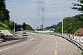
View towards Niedergösgen and the Gösgen nuclear power plant


coat of arms
- Divided twice by red, white and black, covered with a blue, right-turned sickle with a golden handle
The colors of the shield correspond to the coat of arms of the Barons von Bechburg , which was also adopted by the community of Schönenwerd and the district of Gäu.
Personalities
- Rolf Graf (* 1932), racing cyclist
- Hans Huber , composer (1852–1921)
Web links
- Official website of the Eppenberg-Wöschnau community
- Hans Brunner: Eppenberg-Wöschnau. In: Historical Lexicon of Switzerland .
Individual evidence
- ↑ Permanent and non-permanent resident population by year, canton, district, municipality, population type and gender (permanent resident population). In: bfs. admin.ch . Federal Statistical Office (FSO), August 31, 2019, accessed on December 22, 2019 .
Boningen |
Däniken |
Dulliken |
Eppenberg-Wöschnau |
Fulenbach |
Gretzenbach |
Gunzgen |
Hägendorf |
Kappel |
Olten |
Rickenbach |
Schönenwerd |
Starrkirch-Wil |
Walterswil |
Wangen near Olten
Former parishes: Grod
Canton of Solothurn | Districts of the Canton of Solothurn | Municipalities of the Canton of Solothurn