
Kappel SO
| SO is the abbreviation for the canton of Solothurn in Switzerland and is used to avoid confusion with other entries of the name Kappel . |
| Chapel | |
|---|---|
 |
|
| State : |
|
| Canton : |
|
| District : | Olten |
| BFS no. : | 2580 |
| Postal code : | 4616 |
| Coordinates : | 631 099 / 241652 |
| Height : | 425 m above sea level M. |
| Height range : | 404–690 m above sea level M. |
| Area : | 5.10 km² |
| Residents: | 3239 (December 31, 2018) |
| Population density : | 635 inhabitants per km² |
| Website: | www.kappel.ch |
 View of Kappel (from below the church in Hägendorf) |
|
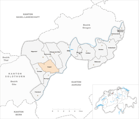
| Location of the municipality | |
  |
|
Kappel is a municipality in the Olten district in the canton of Solothurn in Switzerland .
geography

The village of Kappel is part of the Untergäu , nestled between the southern foot of the Jura and the Born at 425 m above sea level. Of the 509 hectares of community area, 249 hectares are forest, 176 hectares are agricultural land and 82 hectares are settlement areas.
In Kappel, 47% of the municipal area is forest. 200 hectares of which are owned by the Kappel community . In the Bürgerwald there are around 90,000 trees with a diameter of more than 8 cm and a wood mass of around 57,000 cubic meters of wood.
The Born
The Born is a 719 m high hill in the pre-Jura range. The landmark of the municipality of Kappel stands on the Born. A small romantic chapel from 1866. 26 species of trees grow on the Born.
traffic
Kappel is opened up with a bus line , which Olten in half hour starts up. There is also a Swiss Federal Railways stop in the neighboring municipality of Hägendorf . Kappel can also be reached quickly by car, as it is located between the A1 / A2 Oensingen and Oftringen motorway slip roads . There is a bus connection to Olten every half hour ( bus service Olten Gösgen Gäu ).
population
| Population development | |
|---|---|
| year | Residents |
| 1837 | 550 |
| 1850 | 550 |
| 1900 | 532 |
| 1950 | 792 |
| 2007 | 2693 |
| 2013 | 3003 |
coat of arms
- A black hexagonal chapel with a white portal and three white windows in yellow on a black, white corrugated shield base; a black canopy over the portal
Attractions

Kappel Church
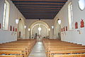
Church, interior view

House in the center of the village


Web links
- Official website of the municipality of Kappel
- Urs Wiesli: Kappel (SO). In: Historical Lexicon of Switzerland .
Individual evidence
- ↑ Permanent and non-permanent resident population by year, canton, district, municipality, population type and gender (permanent resident population). In: bfs. admin.ch . Federal Statistical Office (FSO), August 31, 2019, accessed on December 22, 2019 .
Boningen |
Däniken |
Dulliken |
Eppenberg-Wöschnau |
Fulenbach |
Gretzenbach |
Gunzgen |
Hägendorf |
Kappel |
Olten |
Rickenbach |
Schönenwerd |
Starrkirch-Wil |
Walterswil |
Wangen near Olten
Former parishes: Grod
Canton of Solothurn | Districts of the Canton of Solothurn | Municipalities of the Canton of Solothurn