
Fulenbach
| Fulenbach | |
|---|---|
 |
|
| State : |
|
| Canton : |
|
| District : | Olten |
| BFS no. : | 2575 |
| Postal code : | 4629 |
| Coordinates : | 630 075 / 236396 |
| Height : | 429 m above sea level M. |
| Height range : | 398–435 m above sea level M. |
| Area : | 4.48 km² |
| Residents: | 1777 (December 31, 2018) |
| Population density : | 397 inhabitants per km² |
| Website: | www.fulenbach.ch |
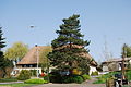
 Post office and Catholic church in the center of Fulenbach |
|
| Location of the municipality | |
  |
|
Fulenbach is a municipality in the Olten district in the canton of Solothurn in Switzerland .
geography
Fulenbach lies at 429 m above sea level. M. , 10 km southwest of the district capital Olten (linear distance). The village extends on the gravel terrace north of the Aare , opposite the Aargau Murgenthal, in the so-called Aaregäu of the Solothurn Mittelland .
The area of the 4.5 km² municipal area comprises a section of the Aare valley in the Swiss plateau. The southern and eastern municipal boundary runs along the Aare, which flows here in a valley around 30 m lower than the surrounding gravel terraces . The left side stream, which flows only a little below Fulenbach, is also slightly sunk into this terrace. The main part of the community area is taken up by this barely relief terrace, which consists of arable and meadow land in the vicinity of the village, in the northern part of extensive forests ( Forenban ). The highest elevation of Fulenbach is 432 m above sea level. M. reached eternity at the resettlement . In 1997, 14% of the municipal area was in settlements, 30% in forests and woodlands, 53% in agriculture and a little more than 3% was unproductive land.
Fulenbach includes the Statt district near the Aare crossing, the Ewigkeit ( 432 m above sea level ) and Färch ( 430 m above sea level ) settlements on the gravel terrace and a few individual farms. Neighboring communities of Fulenbach are Wolfwil , Neuendorf , Härkingen and Boningen in the canton of Solothurn and Murgenthal in the canton of Aargau .
population
| Population development | |
|---|---|
| year | Residents |
| 1837 | 460 |
| 1850 | 464 |
| 1900 | 537 |
| 1950 | 996 |
| 1980 | 1153 |
| 2000 | 1450 |
With 1777 inhabitants (as of December 31, 2018), Fulenbach is one of the medium-sized communities in the canton of Solothurn. 93.9% of the residents speak German, 2.1% speak Albanian and 0.7% speak Italian (as of 2000).
history
The first written mention of the place took place in 1226 under the name Vulenbah . Later the names Fulenbach (1260) and Fulenbac (1263) appeared. The place name is originally derived from a water body name. The old high German word ful has the meaning of sluggish , decaying , which is why the village name can be interpreted as the sluggishly flowing / stinking brook .
Since the Middle Ages , Fulenbach has belonged to the Counts of Frohburg and was part of the Fridau rulership , which was named after a small town in Frohburg at the Aare crossing south of the village. It experienced the same fate as the rule of Fridau and in 1463 came under the direct rule of the city of Solothurn , where it was assigned to the Lower Office of the Bechburg Bailiwick. After the collapse of the Ancien Régime (1798), Fulenbach belonged to the Solothurn administrative district during the Helvetic and from 1803 to the Olten district. The ferry service at the Aare crossing, which has been documented since the 15th century, was discontinued in 1863 with the inauguration of the covered wooden bridge over the river.
Fulenbach already formed an independent parish church in 1253, but was looked after from 1547 to 1679 successively from Hägendorf, Kestenholz and Wolfwil. Since then it has been an independent parish again.

economy
Until well into the 20th century, Fulenbach was predominantly an agricultural community. Even today, arable farming , fruit growing , cattle breeding and forestry have a certain role in the income structure of the population. Further jobs are available in local small businesses and in the service sector. Today in Fulenbach there are companies in the building and transport industry, metal construction, advertising, carpentry and trading companies. In the last few decades Fulenbach has developed into a residential community. Many employed people are therefore commuters who mainly work in the Olten and Langenthal regions.
traffic
The community is very well developed in terms of traffic. It is located on a connecting road from Murgenthal to Hägendorf . The nearest connection to the A1 motorway (Bern-Zurich) is around 6 km from the town center. Fulenbach is connected to the public transport network through a Postbus course , which covers the route from Olten via Wolfwil to Oensingen . On the opposite side of the Aare is the Murgenthal train station on the Olten-Bern line.
Attractions
The sights of Fulenbach include the deer park , the Chäppeli (small chapel) and the Aare bridge . The Chäppeli, actually the Mariahilf Chapel (built in 1697) stands on the site of St. Stephen's Church, which was donated by the Counts of Frohburg in the 13th century. The current village church of Sankt Stephan was built in 1955; there is also a St. Stephen's Chapel.
photos

Entrance to the village coming from Härkingen

Old rectory

Street in the village center
Old farmhouse in the village center

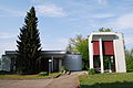
school

Mariahilf Chapel "Chäppeli"

Mariahilf Chapel "Chäppeli"
reformed Church


Personalities
Fulenbach became known nationally through the composer Stephan Jaeggi (1903–1957), who also composed the General Guisan March and the Solothurn March. Beat Jäggi (dialect writer), Franz Anatol Wyss (etcher and painter) and Roman Candio (painter) were also born in Fulenbach, now living in Solothurn. Fernando von Arb became internationally known as the guitarist of the Solothurn rock band Krokus .
coat of arms
- Divided twice by wavy lines of blue with a yellow six-pointed star, white and green
Web links
- Official website of the municipality of Fulenbach
- Urs Wiesli: Fulenbach. In: Historical Lexicon of Switzerland .
- Peter Walliser: Fridau. In: Historical Lexicon of Switzerland .
Individual evidence
- ↑ Permanent and non-permanent resident population by year, canton, district, municipality, population type and gender (permanent resident population). In: bfs. admin.ch . Federal Statistical Office (FSO), August 31, 2019, accessed on December 22, 2019 .
Boningen |
Däniken |
Dulliken |
Eppenberg-Wöschnau |
Fulenbach |
Gretzenbach |
Gunzgen |
Hägendorf |
Kappel |
Olten |
Rickenbach |
Schönenwerd |
Starrkirch-Wil |
Walterswil |
Wangen near Olten
Former parishes: Grod
Canton of Solothurn | Districts of the Canton of Solothurn | Municipalities of the Canton of Solothurn