
Harkingen
| Harkingen | |
|---|---|
 |
|
| State : |
|
| Canton : |
|
| District : | Gäu |
| BFS no. : | 2402 |
| Postal code : | 4624 |
| UN / LOCODE : | CH HKN |
| Coordinates : | 628692 / 239941 |
| Height : | 430 m above sea level M. |
| Height range : | 415–451 m above sea level M. |
| Area : | 5.51 km² |
| Residents: | 1644 (December 31, 2018) |
| Population density : | 298 inhabitants per km² |
| Website: | www.haerkingen.ch |
 Old Church of Härkingen |
|
| Location of the municipality | |
  |
|
Härkingen is a municipality in the Gäu district in the canton of Solothurn in Switzerland .
It is located at the southern foot of the Jura at the motorway triangle of the A1 Zurich – Bern, where the A2 from Basel joins.
history

Neolithic remains on the Buchenrain and Roman finds on the Grenzweg towards Neuendorf are evidence of an early settlement of the municipality. The first documentary mention of the village comes from December 7, 1080 in a deed of donation issued by King Heinrich IV in Speyer as Haerichingen , which means for the members of Haricho . In 1402 Hans von Blauenstein sold Neu-Falkenstein Castle and the four villages of Egerkingen , Härkingen, Neuendorf and Wolfwil to the city of Solothurn . As a result, Härkingen became federal together with Solothurn in 1481.
One of the worst village fires struck the community on March 3, 1730, when 17 straw houses were burned and 22 households became homeless.
In 1754 the new construction of the Johanneskirche in the village center was completed. In 1798 the French invasion army also occupied Härkingen. The freedom tree stood in front of the Lamm tavern. In 1805 Härkingen gained church independence and became its own parish. In 1831, with the new cantonal constitution, the first municipal council was elected. The following family names have been recorded in Härkingen since the 18th century: Burkhardt, Frei, Hauri, Jäggi, Keust, Moll, Oegerli, Pfluger, Studer, Von Arx, Wyss.
In 1953 the village was connected to the sewer system, the village street was paved and the houses were given house numbers.
Probably the oldest building in the village today is the Gasthaus zum Lamm. According to the year chiselled on the arched cellar entrance, the house was built in 1560.
Attractions
population
| Population development | |
|---|---|
| year | Residents |
| 1798 | 310 |
| 1829 | 360 |
| 1850 | 388 |
| 1870 | 336 |
| 1900 | 438 |
| 1950 | 651 |
| 1980 | 812 |
| 2000 | 1196 |
coat of arms
- Yellow rootstock of an oak tree with two branches and three fruits in blue on a green three-mountain
Personalities
- Elisabeth Pfluger (1919–2018), writer and collector of sagas.
- Jules Pfluger (1916–2008), local history researcher
literature
- 900 years of Härkingen. Our village in history and legend. On behalf of the community, written by Jules Pfluger (history), Elisabeth Pfluger (folklore), Karl Gschwind (school history). Olten 1980.
- Old houses and their inhabitants. Jules Pfluger. Published by the community of Härkingen. Olten 1995.
Web links
- Official website of the municipality of Härkingen
- Erich Schenker: Härkingen. In: Historical Lexicon of Switzerland .
- Sarah Jäggi (ZEIT ONLINE): My village
Individual evidence
- ↑ Permanent and non-permanent resident population by year, canton, district, municipality, population type and gender (permanent resident population). In: bfs. admin.ch . Federal Statistical Office (FSO), August 31, 2019, accessed on December 22, 2019 .
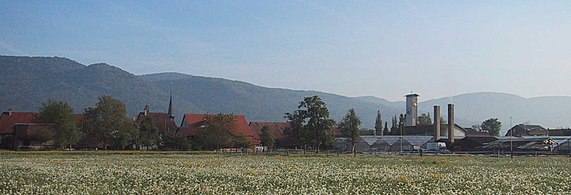
Härkingen to the north on a May morning
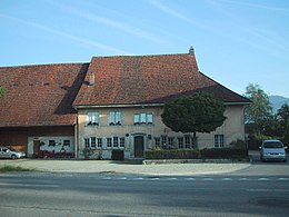
Gasthaus Lamm, built in 1560

The Johanneskirche, built in 1754


