
Starrkirch-Wil
| Starrkirch-Wil | |
|---|---|
 |
|
| State : |
|
| Canton : |
|
| District : | Olten |
| BFS no. : | 2584 |
| Postal code : | 4656 |
| Coordinates : | 636 857 / 244310 |
| Height : | 419 m above sea level M. |
| Height range : | 404-697 m above sea level M. |
| Area : | 1.85 km² |
| Residents: | 1714 (December 31, 2018) |
| Population density : | 926 inhabitants per km² |
| Website: | www.starrkirch-wil.ch |
 Starrkirch-Wil |
|
| Location of the municipality | |
  |
|
Starrkirch-Wil is a municipality in the Olten district in the canton of Solothurn in Switzerland .
geography

Starrkirch-Wil lies at 419 m above sea level. M. , 2 km east of the district capital Olten (linear distance). The double community extends on the ridge between Olten and Dulliken south of the Aare , at the foot of the Engelberg range and at the southern foot of the Jura in Niederamt.
The area of the municipal area of 1.9 km² covers a section of the Aare valley east of Olten in the eastern Solothurn plateau . The area extends from the edge of the Aareniederung in a narrow strip southward over the height adjoining the Hardwald , which is bounded in the east by the Wilerwald , to the anticline of the Engelberg chain off the Jura . This chain in the Starrkirch-Wil area is divided into the Säli mountain ( 664 m above sea level ) to the west and the Engelberg itself to the east of the valley by the hollow of the Wartburghöfe , which has been prepared due to erosion . The highest elevation of Starrkirch-Wil is 695 m above sea level. M. on the western edge of the plateau of the Engelberg. In 1997, 21% of the municipal area was accounted for by settlements, 51% for forests and woodlands and 28% for agriculture.
Starrkirch-Wil consists of the settlement parts Starrkirch ( 419 m above sea level ) south of the Aare valley on the eastern slope of the Hardwald, Wil ( 431 m above sea level ) and Oberwil ( 450 m above sea level ) on the slope northwest of the Engelberg. Neighboring communities of Starrkirch-Wil are Olten and Dulliken in the canton of Solothurn and Oftringen and Aarburg in the canton of Aargau .
population
With 1714 inhabitants (as of December 31, 2018), Starrkirch-Wil is one of the medium-sized communities in the canton of Solothurn. 93.4% of the residents speak German, 2.2% speak Italian and 0.6% speak Spanish (as of 2000). The population of Starrkirch-Wil was 361 in 1850 and 572 in 1900. In the course of the 20th century the population rose continuously to 1124 people until 1970. After a temporary period of stagnation, a significant increase in population has been recorded again since 1990. The settlement area of Starrkirch-Wil has now grown together seamlessly with those of Olten and Dulliken.
economy
Until well into the 20th century, Starrkirch-Wil was more of an agricultural community. Today arable farming , fruit growing and forestry only play a minor role in the employment structure of the population. Further jobs are available in local small businesses and in the service sector. In Starrkirch-Wil, companies from the construction and packaging industries are represented today. Starrkirch-Wil developed into a residential community early on, from which a large proportion of the workforce commutes to work in Olten or Dulliken and the Aarau region .
traffic
The community has good transport connections. Starrkirch is located on main road 5 from Olten to Aarau , and Wil is easy to reach from both Olten and Dulliken . The nearest connection to the A1 motorway (Bern-Zurich) is around 6 km from the town center. Starrkirch and Wil are connected to the public transport network through the courses of the BOGG ( Busbetrieb Olten Gösgen Gäu ).
history
The municipality of Starrkirch-Wil was already settled in the Neolithic and the Bronze Age, which has been proven by various scattered finds. The first documentary mention of Starrkirch took place in 1036 under the name Starrchenchilcha ; The name Starckinchirgun has been handed down from 1045 . The names Starnchilhun (1173) and Starrchilch (1275) appeared later . The place name probably goes back to the Old High German personal name Starco and thus means Church of Starco . Wil appears for the first time as Wilere in the documents in 1217 . Wilon and Wile have been handed down from 1260 , derived from the late Latin word villare (small village, hamlet, homestead).
Starrkirch and Wil have been under the rule of Gösgen since the Middle Ages . The Lords of Ifenthal built a castle on the Fustlig mountain in the 12th century and, a little later, the Vordere or Neu-Wartburg , which was converted into today's Sälischlössli in the 19th century . The Alt-Wartburg (today in the municipality of Oftringen ) was destroyed by the Bernese in 1415 when they conquered the Aargau . The Vordere Wartburg was bought by Solothurn in 1539.
In 1458 Starrkirch and Wil von Solothurn were acquired, incorporated into the Bailiwick of Gösgen and in 1627 assigned to the newly founded Schultheissenamt Olten. After the collapse of the Ancien Régime (1798), Starrkirch-Wil belonged to the Solothurn administrative district during the Helvetic and from 1803 to the Olten district.
As part of the Kulturkampf , the first Christian Catholic parish in Switzerland was established in Starrkirch in 1874 after the Catholic priest Paulin Gschwind refused to announce the resolutions of the 1st Vatican and was therefore excommunicated. The incorporation into Olten, advocated by the residents of Starrkirch-Wil, failed in 1960 due to the resistance of the city.
Attractions
The Christian Catholic Church of St. Peter and Paul goes back to a high medieval building from the time before the year 1000. The church was given its present form when it was rebuilt in 1671. Shortly afterwards, in 1679, Starrkirch became an independent parish. The St. Anna chapel, built in 1844, is located near the lower Wartburghof. A wildlife park was created in Mülitäli .
On the site of the Vorderen Wartburg, which largely fell apart in the course of the 19th century, the Sälischlössli was built in the Belle Epoque style in 1870 .
photos

Christian Catholic Church of Saints Peter and Paul
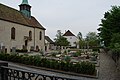
Cemetery and church

Entrance to the village on Hauptstrasse 5 coming from Dulliken


coat of arms
- In blue and white ashlar church front
The speaking coat of arms is derived from the parish seal from 1819.
Web links
- Official website of the Starrkirch-Wil community
- Hans Brunner: Starrkirch-Wil. In: Historical Lexicon of Switzerland .
Individual evidence
- ↑ Permanent and non-permanent resident population by year, canton, district, municipality, population type and gender (permanent resident population). In: bfs. admin.ch . Federal Statistical Office (FSO), August 31, 2019, accessed on December 22, 2019 .
Boningen |
Däniken |
Dulliken |
Eppenberg-Wöschnau |
Fulenbach |
Gretzenbach |
Gunzgen |
Hägendorf |
Kappel |
Olten |
Rickenbach |
Schönenwerd |
Starrkirch-Wil |
Walterswil |
Wangen near Olten
Former parishes: Grod
Canton of Solothurn | Districts of the Canton of Solothurn | Municipalities of the Canton of Solothurn