
Aarburg
| Aarburg | |
|---|---|
 |
|
| State : |
|
| Canton : |
|
| District : | Zofingen |
| BFS no. : | 4271 |
| Postal code : | 4663 |
| UN / LOCODE : | CH AAB |
| Coordinates : | 634 863 / 241122 |
| Height : | 395 m above sea level M. |
| Height range : | 389–636 m above sea level M. |
| Area : | 4.41 km² |
| Residents: | 8362 (December 31, 2019) |
| Population density : | 1896 inhabitants per km² |
|
Proportion of foreigners : (residents without citizenship ) |
44.1% (December 31, 2019) |
| Website: | www.aarburg.ch |
 Aarburg |
|
| Location of the municipality | |
  |
|
Aarburg (in the local dialect : Arbig, ˈɑrb̥iɡ̊ ; French: Aarbourg ) is a small town and municipality in the Swiss canton of Aargau . It belongs to the district of Zofingen , lies on the Aare and borders on the canton of Solothurn .
geography
The community is located on the northern edge of the Wiggertal on the banks of the Aare . The landscape is characterized by a narrow but steep rock spur that extends to the river bank and seals off the valley. It is an extension of the 664 meter high Säli, the westernmost part of Engelberg . At the narrowest point is the medieval old town. To the north of it extends a river plain about one and a half kilometers long, which is also delimited by a narrow point at the opposite end.
The Wigger forms the southern boundary of the municipality. At the same time, about five hundred meters further north, flows the Aarburger Mühletych , an artificial branch built at the beginning of the 16th century. It was once used to drive mill wheels , later as a hydropower supplier for industry. The Mühletych flows into the Aare near the old town, but against its direction of flow. Since the river has a kink at this point and the outflow is hindered by the continuation of the Säli rock spur, this creates a large, slowly rotating vortex, known as the Aare balance or “ woog ”. Flotsam can remain in this vortex for days; This made rafts very easy to collect, which is why Aarburg was once an important starting point for rafting .
The area of the municipality is 441 hectares , of which 135 hectares are forested and 212 hectares are built over. The highest point is below the summit of the Säli at 620 meters, the deepest point at 393 meters on the Aare. Neighboring communities are Olten in the west and north, Starrkirch-Wil in the northeast, Oftringen in the east and Rothrist in the south.
history
Coin finds indicate a settlement by the Celts . In Roman times a road led from the Olten area via Aarburg to central Switzerland . When building a factory came at the beginning of the 20th century a hoard of coins to the fore, especially the coins from the reign of Emperor Tetricus I contained. The coin treasure was probably buried during the Bagauden uprisings of 284/85.
It is not known exactly when the castle was built on the rock spur (today's fortress Aarburg ). In any case, it is mentioned for the first time in 1123 as the property of the Counts of Frohburg . From the castle they administered the Aarburg office , which included the western part of today's Zofingen district, albeit without the city of Zofingen itself. In 1299, the Frohburger sold the castle and the Aarburg office to the Habsburgs . The settlement at the foot of the fortress was first explicitly referred to as a city in 1330. Archaeological finds have shown that the city probably originated around 1312. Wedged between the cities of Olten and Zofingen, both of which are only four kilometers away, Aarburg was unable to develop economically and has always remained a small town. The people of Aarburg lived mainly from the customs revenue that the trade on the Gotthard route brought in.

After a brief siege, the Bernese conquered the town on April 20, 1415. From 1416 the bailiff of the Aarburg office resided at the castle . In the 16th and 17th centuries, the Bernese expanded the castle into a fortress to protect the connection between the Reformed cities of Bern and Zurich at the narrowest point of the Bernese territory from attacks by Catholic neighbors. A port on the «Woog» has been occupied since 1361. As a result, river navigation gained great economic importance, especially during the 17th and 18th centuries.
On March 10, 1798, the French took the city and fortress without a fight. They dissolved the Aarburg office and the regional administrative tasks within the new Helvetic Republic were taken over by Zofingen. The newly created canton of Aargau took over the fortress in 1804, which initially served as a prison and penitentiary. Among other things, escape king Bernhard Matter was imprisoned there; A cantonal reformatory has been housed here since 1893. On May 4, 1840, a major fire raged, which destroyed most of the buildings and the church; 68 families were left homeless as a result. The town was rebuilt, but without the main fortifications. On the rocky spur in front of the fortress, a new church was built between 1842 and 1845.


The first textile factory started operations in 1824. The connection to the railway network took place on June 9, 1856 with the opening of the Aarau - Olten - Zofingen - Emmenbrücke line ; on March 16, 1857, the route to Herzogenbuchsee followed , which was extended to Bern a little later . Aarburg thus developed into a preferred industrial location . In the second half of the 20th century, the community experienced another boost: thanks to the construction of the motorways, even more companies settled and the population doubled.
Attractions
The medieval old town forms a triangle between the river and the wedge-shaped rock bar, which creates a natural boundary on two sides. The houses are grouped around the wedge-shaped main square. The city fortifications on the north side were not rebuilt after the city fire of 1840. The old town is dominated by the narrow and elongated rock bar. On this is the fortress Aarburg , which was built as a castle at the beginning of the 12th century and was expanded into a mighty fortress during the Bernese rule. The building complex is classified as a cultural asset of national importance and today serves as a cantonal youth home .
The Reformed Church stands on a terrace between the fortress and the old town . It was built in the neo-Gothic style from 1842 to 1845 and has two church towers on the west side. Below the church, the rectory built in 1726 leans against the rock spur; until the city fire of 1840, the city gate led through its basement.
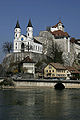
View to the church and the fortress

The little town of Aarburg

Aarburg, Neu-Wartburg ( Sälischlössli ) and the surrounding area from the Höfli

Aarburg and Aare

View of Aarburg from the Aare


coat of arms
The blazon of the city coat of arms reads: "Two-towered black castle with two towers in gold, topped with a golden cross on the lower right, black eagles on the lower left tower." The coat of arms was created before 1415 in the form of a field sign. The eagle can be traced back to a folk etymological interpretation of the Middle High German name aar . The coat of arms was the motif of a Pro Juventute stamp in 1978 .
population
The population developed as follows:
| year | 1400 | 1764 | 1798 | 1850 | 1900 | 1930 | 1950 | 1960 | 1970 | 1980 | 1990 | 2000 | 2010 |
| Residents | about 180 | 569 | 1,029 | 1,700 | 2,300 | 2,833 | 3,512 | 5,303 | 5,943 | 5'354 | 5,725 | 6,263 | 7,033 |
On December 31, 2019, 8,362 people lived in Aarburg, the proportion of foreigners was 44.1%. In the 2015 census, 28.6% described themselves as Roman Catholic and 18.1% as Reformed ; 53.3% were non-denominational or of other faiths. In the 2000 census, 77.9% stated German as their main language, 6.0% Italian , 3.7% Serbo-Croatian , 3.5% Turkish , 3.0% Portuguese , 2.1% Albanian and 1.3% Spanish .
Politics and law
The assembly of those entitled to vote, the municipal assembly , exercises legislative power. The executing authority is the five-member municipal council . He is elected by the people in the majority procedure, his term of office is four years. The parish council leads and represents the parish. To this end, it implements the resolutions of the municipal assembly and the tasks assigned to it by the canton. The five municipal councils for the 2018–2021 term are:
- Hans-Ulrich Schär (independent), mayor
- Martina Bircher ( SVP ), vice-manager
- Rolf Walser ( SP )
- Fredy Nater ( FDP )
- Dino Di Fronzo ( FDP )
The District Court of Zofingen is primarily responsible for legal disputes . Aarburg belongs to the Peace Judges' Circle XV (Rothrist).
Aarburg introduced the residents' council in 1972 , but abolished it in 1989 and returned to the "proper community organization" with community assembly.
economy
According to the corporate structure statistics (STATENT) collected in 2015, there are around 3,100 jobs in Aarburg, of which 0.4% are in agriculture, 31.9% in industry and 67.7% in the service sector. The municipality was chosen as a location by over 300 companies because of its favorable location at the A1 / A2 motorway junction and the nearby Olten railway junction. The metal and kitchen construction company Franke and the underwear manufacturer Zimmerli , among others, are based in Aarburg .
traffic
The SBB train station in Aarburg-Oftringen is located exactly on the municipal boundary. Regional trains run to Olten , Langenthal and Lucerne . The station is the terminus of a line operated by Limmat Bus to Zofingen station and a BOGG bus line to Olten and Trimbach . On weekends, night buses run from Olten train station via Aarburg to Oberbuchsiten or Vordemwald .
Aarburg is just a few minutes' drive from the Rothrist and Oftringen connections of the A1 motorway on Hauptstrasse 2 . Before the opening of the 1,800-meter-long bypass road, over 30,000 vehicles squeezed through the narrow town, more than, for example, on the Gotthard motorway. After a planning phase lasting over 15 years, construction work began in September 2004. The new road was opened to traffic on November 21, 2007. Over half of it runs in two tunnels.
education
The community has six kindergartens and three school houses. All types of compulsory elementary school are taught in these: the primary school in the Höhe and Hofmatt school buildings as well as the district school , secondary school and junior high school in the Paradiesli school building. The closest grammar school is the Zofingen Cantonal School .
Personalities
- Franz Theodor Aerni (1853–1918), painter
- Albrecht Bohnenblust (1770–1841), councilor and judge
- Ivan Dreyfus (1884–1975), football player
- Adolf Gloor (1884–1944), National Councilor and trade unionist
- Marlies Graf-Dätwyler (1943–2020), filmmaker
- Jacques-Barthélemy Micheli du Crest (1690–1766), politician and geodesist, fortress imprisonment 1746–1766 on the Aarburg
- Arnold Niggli (1843–1927), music historian and critic
- Friedrich Niggli (1875–1959), composer and music teacher
- Isaak Steiger (1669–1749), mayor of Bern
- Paul Arnold Walty (1881-1969), football player
- Adolf Welti (1876–1951), National Councilor and doctor
literature
- Andreas Steigmeier : Aarburg (municipality). In: Historical Lexicon of Switzerland .
- Michael Stettler : The art monuments of the canton of Aargau . Ed .: Society for Swiss Art History . Volume I: The districts of Aarau, Kulm, Zofingen. Wiese Verlag, Basel 1948, DNB 366495623 .
- Franz Oswald, Peter Baccini : Netzstadt - Introduction to urban design . Birkhäuser Verlag, Basel 2003, ISBN 3-7643-6962-0 (urban development theory, explanation of the Netzstadt using the example of the “Stadt an der Wigger”, consisting of Aarburg, Oftringen, Rothrist, Strengelbach and Zofingen).
Web links
- Official website of the municipality of Aarburg
- Aarburg on the ETHorama platform
Individual evidence
- ↑ Cantonal population statistics 2019. Department of Finance and Resources, Statistics Aargau, March 30, 2020, accessed on April 2, 2019 .
- ↑ Cantonal population statistics 2019. Department of Finance and Resources, Statistics Aargau, March 30, 2020, accessed on April 2, 2019 .
- ^ Beat Zehnder: The community names of the canton of Aargau . Historical sources and linguistic interpretations. In: Historical Society of the Canton of Aargau (Ed.): Argovia . Annual journal of the Historical Society of the Canton of Aargau. tape 100 / II . Verlag Sauerländer, Aarau 1991, ISBN 3-7941-3122-3 , p. 56-57 . Specified phonetic transcription : árbịg .
- ↑ a b National map of Switzerland, sheet 1108, Swisstopo.
- ↑ The Aare scale - a unique natural phenomenon. swissinfo , August 6, 2003, accessed January 4, 2010 .
- ↑ Standard area statistics - municipalities according to 4 main areas. Federal Statistical Office , November 26, 2018, accessed on May 29, 2019 .
- ^ Martin Hartmann, Hans Weber: The Romans in Aargau . Verlag Sauerländer, Aarau 1985, ISBN 3-7941-2539-8 , p. 161 .
- ↑ History of the city on aarburg.ch
- ↑ Annelies Hüssy, Christoph Reding, Jürg Andrea Bossardt, Manfred A. Frey, Hans Peter Neuenschwander: The castle and fortress Aarburg . Ed .: Society for Swiss Art History. Swiss art guide, volume 819 , series 82.Bern 2007, ISBN 978-3-85782-819-5 .
- ^ Stettler: The art monuments of the Canton of Aargau, Volume I: The districts of Aarau, Kulm, Zofingen. Pp. 249-250.
- ^ Joseph Galliker, Marcel Giger: Municipal coat of arms of the Canton of Aargau . Lehrmittelverlag des Kantons Aargau, book 2004, ISBN 3-906738-07-8 , p. 101 .
- ↑ Population development in the municipalities of the Canton of Aargau since 1850. (Excel) In: Eidg. Volkszählung 2000. Statistics Aargau, 2001, archived from the original on October 8, 2018 ; accessed on May 29, 2019 .
- ↑ Resident population by religious affiliation, 2015. (Excel) In: Population and Households, Community Tables 2015. Statistics Aargau, accessed on May 29, 2019 .
- ↑ Swiss Federal Census 2000: Economic resident population by main language as well as by districts and municipalities. (Excel) Statistics Aargau, archived from the original on August 10, 2018 ; accessed on May 29, 2019 .
- ↑ circles of justice of the peace. Canton of Aargau, accessed on June 21, 2019 .
- ↑ Urs Hofmann : The residents' council: loss of democracy or gain in democracy? (PDF, 62 kB) Department of Economics and Home Affairs, March 14, 2016, accessed on June 27, 2019 .
- ↑ Statistics of the corporate structure (STATENT). (Excel, 157 kB) Statistics Aargau, 2016, accessed on May 29, 2019 .
- ↑ Gian Andrea Marti: Bypass roads are a blessing and a curse for business. Neue Zürcher Zeitung , February 16, 2018, accessed on May 29, 2019 .
Aarburg | Bottenwil | Brittnau | Kirchleerau | Kölliken | Moosleerau | Murgenthal | Oftringen | Reitnau | Rothrist | Safenwil | Staffelbach | Strengelbach | Uerkheim | Vordemwald | Wiliberg | Zofingen
Former municipality: Attelwil | Balzenwil | Mühlethal | Riken | Wittwil
Canton of Aargau | Districts of the Canton of Aargau | Municipalities in the Canton of Aargau

Four parishes: Bolligen | Vechigen | Stettlen | Muri
Regional courts: Seftigen | Sternenberg | Konolfingen | Zollikofen
Offices: Thun | Zofingen | Aarau | Lenzburg | Brugg | Burgdorf | Büren | Unterseen | Wiedlisbach | Obersimmental | Lower Simmental | Frutigen | Oberhofen | Aigle | Hasli | Trachselwald | Bipp | Aarwangen | Cheeks | Landshut | Lenzburg (Office) | Schenkenberg | Aarberg | Nidau | Erlach | Laupen | Oltigen | Signau | Biberstein | Aarburg | Saanen | Brandis | Interlaken | Königsfelden | Thorberg | Fraubrunnen | Zofingen (pen) | Frienisberg | St. Johannsen | Gottstatt | Buchsee | Sumiswald | Roche (Saline) | Köniz | Kasteln | Hettiswil
Offices in Vaud: Avenches | Moudon | Yverdon | Lausanne | Morges | Nyon | Vevey | Romainmôtier | Oron | Payerne | Bonmont | Aubonne
Common lords with Freiburg: Schwarzenburg | Murten | Grandson | Echallens
Common federal dominions: Baden | Thurgau | Free offices | Rhine Valley | Sargans | Locarno | Lugano | Mendrisio | Valle Maggia
Offices and services in the city of Bern: Bauamt | Salt Directorate | Mushafen | Pen | Corn Office | Big hospital | Inselspital