
Brittnau
| Brittnau | |
|---|---|
 |
|
| State : |
|
| Canton : |
|
| District : | Zofingen |
| BFS no. : | 4274 |
| Postal code : | 4805 |
| UN / LOCODE : | CH BTA |
| Coordinates : | 638 486 / 234449 |
| Height : | 451 m above sea level M. |
| Height range : | 432–613 m above sea level M. |
| Area : | 13.67 km² |
| Residents: | 3948 (December 31, 2019) |
| Population density : | 289 inhabitants per km² |
|
Proportion of foreigners : (residents without citizenship ) |
10.8% (December 31, 2019) |
| Website: | www.brittnau.ch |
 Brittnau |
|
| Location of the municipality | |
  |
|
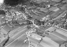
Brittnau ( Swiss German ˈprɪtːˌnɔu ) is a municipality in the Swiss canton of Aargau . It belongs to the district of Zofingen , is located in the lower Wiggertal and borders the canton of Lucerne .
geography
The village center is located immediately west of the Wigger on a raised side terrace. The Altachenbach, which also forms the border with the canton of Lucerne , flows parallel to the Wigger at an average distance of 250 meters . The flat, elongated area in between is completely built over. One kilometer north of the village center is the Hard district on the western edge of the Wiggerebene. A hilly zone extends west of the plain with the Chilchberg ( 583 m above sea level ), the Stockhubel ( 546 m above sea level ) and the Schürberg ( 532 m above sea level ). Both the side valleys in between (ditch and suburb) and the Schürberg plateau are also built over. The Heidenhubel ( 614 m above sea level ), a foothill of the Brettschellenberg, rises to the far south .
The valley zone and the Schürberg are historically considered to be the “inner community”. To the west of the three hills, in the Pfaffneren catchment area , is the so-called “outer community”. This includes the small hamlets and individual farms Bergacker, Bösenwil, Bötschishalden, Fennern, Geissbach, Grod, Leidenberg, Liebigen, Mattenwil, Rossweid, Sennhof and Wilacker.
The area of the municipality is 1367 hectares , of which 473 hectares are forested and 170 hectares are built over. The highest point is on the Heidenhubel at 614 meters, the lowest point at 433 meters on the Wigger. Neighboring communities are Murgenthal in the west, Vordemwald in the northwest, Strengelbach in the north, Zofingen in the northeast and the Lucerne communities Wikon in the east, Langnau bei Reiden in the south and Pfaffnau in the southwest.
history
Finds on the Chilchberg prove a settlement during the Neolithic Age , on the Schürberg Roman coins and an Alemannic grave from the 7th century were discovered. Pritinuova was first mentioned in a document in 893, in an interest sled from the Fraumünster in Zurich . This form of the place name goes back to the Old High German term for "water-near land of the Prito". The foundation walls of the church date from around the year 1000. The village of Brittnau and the surrounding hamlets were then part of the Aarburg office , which was owned by the Counts of Frohburg . They sold the office in 1299 to the Habsburgs , who thus had blood jurisdiction. They shared the lower jurisdiction with the Lords of Büttikon , who resided in the nearby Wikon Castle.
In 1415 the confederates conquered Aargau. The area around Brittnau now belonged to the subject area of the city of Bern , the so-called Berner Aargau . In 1481 the lords of Büttikon sold half of their rulership rights to the Bernese, and in 1516 the rest as well. Bern now exercised sole power over Brittnau and in 1528 introduced the Reformation . The St. Urban monastery (located in the area of the Catholic estate of Lucerne ) remained the most important landowner and feudal lord. On July 26th 1547 a devastating fire destroyed the village, which was then rebuilt.
Even under the rule of Bern, the Brittnauer had their own subordinate and had their own court, which was composed of six representatives each from the inner and outer community. Compared to surrounding villages, this special position enabled a certain degree of independence, which was often exploited to the limit of what was permitted. In March 1798 the French took Switzerland, ousted the «Gracious Lords» of Bern and proclaimed the Helvetic Republic . The part of the Aarburg office to the west of the Wigger initially belonged to the Langenthal district in the canton of Bern , but came to the canton of Aargau in March 1803 when the mediation act came into force .
By the middle of the 19th century, large parts of the population were impoverished. Between 1851 and 1855 alone, local authorities forced 155 residents to emigrate to North America in order to reduce welfare costs. The Aarau - Olten - Emmenbrücke railway line had already opened on June 9, 1856, but Brittnau only got its own train station in 1910 (together with Wikon). After a period of growth up to around 1930, the population stagnated for several decades. Since the opening of the A2 motorway in 1980, there has been increased growth again and the community is developing more and more into a suburb of Zofingen .
Attractions


The village fire of 1547 almost completely destroyed the medieval church, only a small part of the north wall was preserved. The completion of the new church was delayed until 1585. In 1641 the nave was lengthened by a third.
The mill, built in 1603, stands on the banks of the Wigger, a solid structure under a bent gable roof . The most striking feature is the attached octagonal stair tower with a pointed tent roof . In the Ausserdorf there is a granary built from wood in 1752.
Free-living storks were at home in Brittnau until 1927 , after which they disappeared. As early as 1915, the news-world newspaper linked the disappearance with the loud noise and the ability to move quickly from overflying fighter planes . It was not until 1960 that four Algerian young storks moved into the newly created stork's nest in the gymnasium as part of the nationwide resettlement attempt . In decades of efforts, their descendants were raised in a specially constructed enclosure and made settled again. After the keeping of the enclosure was loosened in 1995, the storks received food only in exceptional cases and moved to their winter quarters in late autumn. The resettlement attempt has been considered successful since 2001, and storks are now part of the townscape and sometimes overwinter on site. The enclosure was demolished in spring 2007.
coat of arms
The blazon of the municipality's coat of arms reads: "In red over the green Dreiberg, white inclined left river." The sloping river first appeared in 1581 on the chalice of the parish church of Brittnau. In 1811 a three mountain was added to the community seal. In 1963, the cantonal coat of arms commission proposed that the Dreiberg be abandoned, but the local council rejected this.
population
The population developed as follows:
| year | 1850 | 1900 | 1930 | 1950 | 1960 | 1970 | 1980 | 1990 | 2000 | 2010 |
| Residents | 2,249 | 2,229 | 2,615 | 2,972 | 3,070 | 2,888 | 2,822 | 3,091 | 3'400 | 3,652 |
On December 31, 2019, 3948 people lived in Brittnau, the proportion of foreigners was 10.8%. In the 2015 census, 48.9% described themselves as Reformed and 22.7% as Roman Catholic ; 28.4% were non-denominational or of other faiths. In the 2000 census, 96.1% said their main language was German , 1.2% Italian and 0.7% Portuguese .
Politics and law


The assembly of those entitled to vote, the municipal assembly , exercises legislative power. The executing authority is the five-member municipal council . He is elected by the people in the majority procedure, his term of office is four years. The parish council leads and represents the parish. To this end, it implements the resolutions of the municipal assembly and the tasks assigned to it by the canton. The District Court of Zofingen is primarily responsible for legal disputes . Brittnau belongs to the Peace Judges' Circle XVI (Zofingen).
economy
According to the company structure statistics (STATENT) collected in 2015, there are around 680 jobs in Brittnau, of which 22% are in agriculture, 21% in industry and 57% in the service sector. Although numerous small and medium-sized industrial and service companies have settled here, agriculture is still of great importance. The municipality has the second largest arable land in the canton. Most of the employed are commuters and work in Zofingen and the surrounding area.
traffic
Brittnau can be reached via secondary roads, but is only two kilometers from the main road 2 from Olten to Lucerne and the Reiden junction of the A2 motorway. From Zofingen train station , two Limmat Bus lines operate on different routes to Brittnau. The hamlets of Grod and Liebigen are accessed by the Zofingen– St. Urban line . East of the village center, in the area of the municipality of Wikon, is the SBB train station Brittnau-Wikon on the Lucerne – Olten railway line , where regional trains to Olten and Lucerne stop. On weekends there is a night bus from Olten train station via Zofingen and Brittnau to Vordemwald .
education
The community has two kindergartens and three school houses in which the primary school , the junior high school and the secondary school are taught. The district school can be attended in Zofingen . The closest grammar school is the Zofingen Cantonal School .
Personalities
- Ernst Aeppli (1892–1954), psychoanalyst
- Markus Flückiger (* 1969), hand organ player
- Emma Kunz (1892–1963), alternative practitioner and artist
- Werner Wälchli (1922–2010), graphic artist, lithographer, draftsman and painter
literature
- Andreas Steigmeier : Brittnau. In: Historical Lexicon of Switzerland .
- Michael Stettler : The art monuments of the canton of Aargau . Ed .: Society for Swiss Art History . Volume I: The districts of Aarau, Kulm, Zofingen. Wiese Verlag, Basel 1948, DNB 366495623 .
Web links
Individual evidence
- ↑ Cantonal population statistics 2019. Department of Finance and Resources, Statistics Aargau, March 30, 2020, accessed on April 2, 2019 .
- ↑ Cantonal population statistics 2019. Department of Finance and Resources, Statistics Aargau, March 30, 2020, accessed on April 2, 2019 .
- ↑ a b Beat Zehnder: The community names of the canton of Aargau . In: Historical Society of the Canton of Aargau (Ed.): Argovia . tape 100 . Verlag Sauerländer, Aarau 1991, ISBN 3-7941-3122-3 , p. 110-111 .
- ↑ a b National map of Switzerland, sheet 1109, Swisstopo.
- ↑ Standard area statistics - municipalities according to 4 main areas. Federal Statistical Office , November 26, 2018, accessed on May 29, 2019 .
- ^ Stettler: The art monuments of the Canton of Aargau, Volume I: The districts of Aarau, Kulm, Zofingen. Pp. 266-269.
- ↑ Michael Stettler: The art monuments of the Canton of Aargau, Volume I: The districts of Aarau, Kulm, Zofingen. Pp. 269-270.
- ↑ (News) Welt Blatt of December 19, 1915, page 12
- ↑ Stork enclosure in the ditch. Brittnau community, archived from the original on September 23, 2007 ; Retrieved January 4, 2010 .
- ^ Joseph Galliker, Marcel Giger: Municipal coat of arms of the Canton of Aargau . Lehrmittelverlag des Kantons Aargau, book 2004, ISBN 3-906738-07-8 , p. 131 .
- ↑ Population development in the municipalities of the Canton of Aargau since 1850. (Excel) In: Eidg. Volkszählung 2000. Statistics Aargau, 2001, archived from the original on October 8, 2018 ; accessed on May 29, 2019 .
- ↑ Resident population by religious affiliation, 2015. (Excel) In: Population and Households, Community Tables 2015. Statistics Aargau, accessed on May 29, 2019 .
- ↑ Swiss Federal Census 2000: Economic resident population by main language as well as by districts and municipalities. (Excel) Statistics Aargau, archived from the original on August 10, 2018 ; accessed on May 29, 2019 .
- ↑ circles of justice of the peace. Canton of Aargau, accessed on June 21, 2019 .
- ↑ Statistics of the corporate structure (STATENT). (Excel, 157 kB) Statistics Aargau, 2016, accessed on May 29, 2019 .
Aarburg | Bottenwil | Brittnau | Kirchleerau | Kölliken | Moosleerau | Murgenthal | Oftringen | Reitnau | Rothrist | Safenwil | Staffelbach | Strengelbach | Uerkheim | Vordemwald | Wiliberg | Zofingen
Former municipality: Attelwil | Balzenwil | Mühlethal | Riken | Wittwil
Canton of Aargau | Districts of the Canton of Aargau | Municipalities in the Canton of Aargau