
Moosleerau
| Moosleerau | |
|---|---|
 |
|
| State : |
|
| Canton : |
|
| District : | Zofingen |
| BFS no. : | 4277 |
| Postal code : | 5054 |
| UN / LOCODE : | CH MLU |
| Coordinates : | 647 400 / 235558 |
| Height : | 509 m above sea level M. |
| Height range : | 471–713 m above sea level M. |
| Area : | 3.81 km² |
| Residents: | 898 (December 31, 2019) |
| Population density : | 236 inhabitants per km² |
|
Proportion of foreigners : (residents without citizenship ) |
14.1% (December 31, 2019) |
| Website: | www.moosleerau.ch |
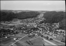
 View of Moosleerau |
|
| Location of the municipality | |
  |
|
Moosleerau (in the local dialect Moslerb, ˈmosˌleːrb ) is a municipality in the Swiss canton of Aargau . It belongs to the district of Zofingen , is located in the middle of the Suhrental and borders on the canton of Lucerne .
geography
The village is located on the eastern edge of the completely flat valley floor on a slightly elevated lateral moraine . This was created during the Würme Ice Age when the Reuss Glacier retreated . The Suhre forms the western boundary of the municipality. The river was straightened in the mid-1920s and the extensive swamp in the plain drained. Immediately to the east of the village, the Stieregart ( 624 m above sea level ) rises steeply. A side valley over a kilometer long branches off at the southern edge of the village. It lies between the Stieregart and the Längegg ( 653 m above sea level ) and climbs up to the Nutziweid ( 708 m above sea level ) and the Rossücken ( 713 m above sea level ). These foothills of an elongated plateau form the natural border to the Ruedertal . The development has grown together with that of Kirchleerau .
The area of the municipality is 381 hectares , of which 108 hectares are forested and 53 hectares are built over. The highest point is at 713 meters on the Rossrücke, the lowest at 474 meters on the Suhre. Neighboring communities are Reitnau in the southwest, Staffelbach in the northwest, Kirchleerau in the north, Schmiedrued in the east and the Lucerne municipality of Triengen in the south.
history
Finds of bricks and wall remains in neighboring Kirchleerau indicate that the area was already inhabited by the Romans . Moslerovva was first mentioned in a document in 1243. The name comes from the Old High German lewirouwo , which means "in the land of graves near the water". The addition of moss indicates swampy terrain. In the Middle Ages the village was under the rule of the Counts of Lenzburg , from 1173 on that of the Counts of Kyburg . After these died out, the Habsburgs took over sovereignty and blood jurisdiction in 1273 .
In 1415 the confederates conquered Aargau. Moosleerau now belonged to the subject area of the city of Bern , the so-called Bernese Aargau . From the 15th century the village was part of the Rued rule, a judicial district within the Lenzburg office . The owners of the rulership exercised the lower jurisdiction and were the main landowners. After various noble families from the surrounding area had owned the estate, it was acquired in 1520 by the Lords of May, who originally came from Italy . Their residence was the Rued Castle in neighboring Ruedertal . In 1528 the Bernese introduced the Reformation .
In March 1798 the French took Switzerland, ousted the «Gracious Lords» of Bern and proclaimed the Helvetic Republic . Since then, Moosleerau has belonged to the canton of Aargau. It was not until 1834 that the May sold their last remaining rights to the canton. Agriculture shaped the life of the community well into the 20th century . Since the beginning of the 1980s, the population has increased by more than forty percent due to increased construction activity.
Attractions
coat of arms
The blazon of the municipal coat of arms reads: "In white on green ground covered with white river, brown moss harrier on black perch between two black cattails on green leafy stems." The bird on the pole goes back to a pane of glass painted in 1683 in the church of Schöftland . In 1961 the reed wall was replaced by two cattails, but the unheraldic brown color of the bird was retained.
population
The population developed as follows:
| year | 1764 | 1850 | 1900 | 1930 | 1950 | 1960 | 1970 | 1980 | 1990 | 2000 | 2010 |
| Residents | 298 | 646 | 452 | 459 | 531 | 546 | 599 | 593 | 724 | 798 | 853 |
On December 31, 2019, 898 people lived in Moosleerau, the proportion of foreigners was 14.1%. In the 2015 census, 51.5% described themselves as Reformed and 21.6% as Roman Catholic ; 26.9% were non-denominational or of other faiths. 92.0% said German as their main language in the 2000 census , 2.5% Albanian and 2.1% Italian .
Politics and law
The assembly of those entitled to vote, the municipal assembly , exercises legislative power. The executing authority is the five-member municipal council . He is elected by the people in the majority procedure, his term of office is four years. The parish council leads and represents the parish. To this end, it implements the resolutions of the municipal assembly and the tasks assigned to it by the canton. The District Court of Zofingen is primarily responsible for legal disputes . Moosleerau belongs to the XVI judges of peace (Zofingen).
economy
According to the corporate structure statistics (STATENT) collected in 2015, there are around 350 jobs in Moosleerau, 7% of them in agriculture, 54% in industry and 39% in the service sector. The most important employers are a manufacturing company in the chemical industry and a construction company. Most of the employed are commuters and work in the lower Suhrental or in the Aarau region .
traffic
Moosleerau is located on Hauptstrasse 24 between Aarau and Sursee . The connection to public transport is provided by a post bus line from Schöftland to Sursee train station .
education

The community has a school building with a kindergarten and primary school . The Realschule and the secondary school can be attended in Staffelbach , the district school in Schöftland . The closest grammar school is the Zofingen Cantonal School .
literature
- Christian Lüthi: Moosleerau. In: Historical Lexicon of Switzerland .
- Michael Stettler : The art monuments of the canton of Aargau . Ed .: Society for Swiss Art History . Volume I: The districts of Aarau, Kulm, Zofingen. Wiese Verlag, Basel 1948, DNB 366495623 .
Web links
Individual evidence
- ↑ Cantonal population statistics 2019. Department of Finance and Resources, Statistics Aargau, March 30, 2020, accessed on April 2, 2019 .
- ↑ Cantonal population statistics 2019. Department of Finance and Resources, Statistics Aargau, March 30, 2020, accessed on April 2, 2019 .
- ↑ a b Beat Zehnder: The community names of the canton of Aargau . In: Historical Society of the Canton of Aargau (Ed.): Argovia . tape 100 . Verlag Sauerländer, Aarau 1991, ISBN 3-7941-3122-3 , p. 277-280 .
- ^ National map of Switzerland, sheet 1109, Swisstopo.
- ↑ Standard area statistics - municipalities according to 4 main areas. Federal Statistical Office , November 26, 2018, accessed on May 27, 2019 .
- ^ Joseph Galliker, Marcel Giger: Municipal coat of arms of the Canton of Aargau . Lehrmittelverlag des Kantons Aargau, book 2004, ISBN 3-906738-07-8 , p. 217 .
- ↑ Population development in the municipalities of the Canton of Aargau since 1850. (Excel) In: Eidg. Volkszählung 2000. Statistics Aargau, 2001, archived from the original on October 8, 2018 ; accessed on May 27, 2019 .
- ↑ Resident population by religious affiliation, 2015. (Excel) In: Population and Households, Community Tables 2015. Statistics Aargau, accessed on May 27, 2019 .
- ↑ Swiss Federal Census 2000: Economic resident population by main language as well as by districts and municipalities. (Excel) Statistics Aargau, archived from the original on August 10, 2018 ; accessed on May 27, 2019 .
- ↑ circles of justice of the peace. Canton of Aargau, accessed on June 21, 2019 .
- ↑ Statistics of the corporate structure (STATENT). (Excel, 157 kB) Statistics Aargau, 2016, accessed on May 27, 2019 .
Aarburg | Bottenwil | Brittnau | Kirchleerau | Kölliken | Moosleerau | Murgenthal | Oftringen | Reitnau | Rothrist | Safenwil | Staffelbach | Strengelbach | Uerkheim | Vordemwald | Wiliberg | Zofingen
Former municipality: Attelwil | Balzenwil | Mühlethal | Riken | Wittwil
Canton of Aargau | Districts of the Canton of Aargau | Municipalities in the Canton of Aargau