
Safenwil
| Safenwil | |
|---|---|
 |
|
| State : |
|
| Canton : |
|
| District : | Zofingen |
| BFS no. : | 4283 |
| Postal code : | 5745 |
| UN / LOCODE : | CH SAF |
| Coordinates : | 641 159 / 241013 |
| Height : | 484 m above sea level M. |
| Height range : | 429–643 m above sea level M. |
| Area : | 5.99 km² |
| Residents: | 3934 (December 31, 2019) |
| Population density : | 657 inhabitants per km² |
|
Proportion of foreigners : (residents without citizenship ) |
24.5% (December 31, 2019) |
| Website: | www.safenwil.ch |
 View of a large part of the village from Walterswil |
|
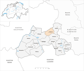
| Location of the municipality | |
  |
|
Safenwil ( Swiss German ˌz̥ɑv̥əˈʋiːʊ ) is a municipality in the Swiss canton of Aargau . It belongs to the district of Zofingen , lies between the Uerkental and the Wiggertal and borders the canton of Solothurn .
geography
The community lies in a hollow at the transition between the valleys of the Wigger in the west and the Uerke in the east. In the south of this hollow rise the 644 meter high Hochwacht and the 626 meter high Halden. Safenwil is a scattered settlement and consists of several districts that grew together loosely in the second half of the 20th century. The motorway and railway line form a distinctive dividing line. The districts of Striegel, Dorf and Dörfli are to the south of these main traffic axes, while the districts of Fritz, Hard and Holz are to the north (viewed from west to east). The municipality is drained to the east by the Mülibach, which flows into the Uerke.
The area of the municipality is 599 hectares , of which 277 hectares are forested and 166 hectares are built over. The highest point is at 644 meters on the Hochwacht, the lowest at 450 meters on the eastern municipality border. Neighboring communities are Kölliken in the east, Uerkheim in the southeast, Zofingen in the south, Oftringen in the west and the Solothurn communities Walterswil and Gretzenbach in the north.
history
The area around Safenwil was already settled during Roman times. There was a manor on the mule track between the Wiggertal and the legionary camp in Vindonissa . The Alemanni settled in the 7th or 8th century. In 893 Sabenewilare was first mentioned in an interest sled in the Fraumünster in Zurich . The place name comes from the Old High German Sabininwilari and means "Hofsiedlung des Sabino".

In the Middle Ages the village was under the rule of the Counts of Lenzburg , from 1173 on that of the Counts of Kyburg . After these were extinct, the Habsburgs took over the sovereignty in 1273 and were the owners of blood jurisdiction . At that time there was a small Scherenberg castle on the Sodhubel , of which only the foundations have been preserved. In 1361 the lords of Ifenthal took over the bailiwick of Safenwil including the lower jurisdiction from the barons of Belp .
In 1415 the confederates conquered Aargau. Safenwil now belonged to the subject area of the city of Bern , the so-called Berner Aargau . In 1458, the city of Solothurn acquired lower jurisdiction over the area around Gösgen , including Safenwil. Bern felt compelled to unite all rights on its territory in one hand, but this only succeeded in 1665. As a result, Safenwil and Uerkheim formed a judicial district within the Lenzburg office . In 1528 the Bernese introduced the Reformation . In March 1798 the French took Switzerland, ousted the «Gracious Lords» of Bern and proclaimed the Helvetic Republic . Since then, Safenwil has belonged to the canton of Aargau.
In 1866 Safenwil received its own reformed church after the village had been part of a church before the Reformation after Gretzenbach , from 1528 to Zofingen and from 1616 to Kölliken . Commercial, industrial and commercial displaced agriculture early on due to the expansion of the road Zurich -Berne in the 1770s and the opening of the railway line Zofingen-Wettingen the National Railway on September 6, 1877. Since 1900, has nearly tripled the population. The opening of the autobahn in 1967 led to a rapid economic upswing, but the community has since been divided into two parts and suffers from a lot of noise pollution.
coat of arms


The blazon of the municipal coat of arms reads: "In blue and white boar head, overlaid by a six-pointed yellow star." The coat of arms, which first appeared on the municipal seal in 1811, was created due to a misunderstanding. The medieval spelling Savenwil was incorrectly interpreted as Sauenwil . In 1963, the five-pointed white star was replaced by a yellow star with six rays.
Attractions
The village museum in the former school and community building deals with the settlement, industrial and cultural history of the community. The Emil Frey Group operates the Classic Car Museum in the halls of a former textile factory, in which up to 60 vintage vehicles from predominantly British and Japanese production are presented.
population
The population developed as follows:
| year | 1764 | 1798 | 1850 | 1900 | 1930 | 1950 | 1960 | 1970 | 1980 | 1990 | 2000 | 2010 |
| Residents | 506 | 713 | 1'200 | 1,347 | 1,781 | 1'919 | 2,396 | 2,608 | 2,568 | 2,957 | 3,128 | 3,489 |
On December 31, 2019, 3,934 people lived in Safenwil, the proportion of foreigners was 24.5%. In the 2015 census, 36.5% described themselves as Reformed and 22.0% as Roman Catholic ; 41.5% were non-denominational or of other faiths. In the 2000 census, 92.1% stated German as their main language, 1.6% Italian , 1.5% Albanian , 1.2% Serbo-Croatian and 0.5% French .
Politics and law
The assembly of those entitled to vote, the municipal assembly , exercises legislative power. The executing authority is the five-member municipal council . He is elected by the people in the majority procedure, his term of office is four years. The parish council leads and represents the parish. To this end, it implements the resolutions of the municipal assembly and the tasks assigned to it by the canton. The District Court of Zofingen is primarily responsible for legal disputes . Safenwil belongs to the Peace Judges' Circle XVI (Zofingen).
economy
According to the company structure statistics (STATENT) collected in 2015, Safenwil has around 1,600 jobs, 3% of them in agriculture, 22% in industry and 75% in the service sector. The best known and by far the most important company is the Emil Frey Group . It is active in the import and trade of automobiles (including Toyota , Subaru , Jaguar , Suzuki ) and is the largest company of its kind in Switzerland. Many people in employment are commuters and work in the Zofingen or Aarau regions .
traffic
Hauptstrasse 1 runs through Safenwil from Zurich to Bern . The Oftringen junction of the A1 motorway, which runs right through the village, is a few kilometers to the west. The connection to public transport is provided by the SBB - Lenzburg – Zofingen railway line with Safenwil station and Walterswil-Striegel station.
education
The community has a kindergarten and three schoolhouses, in which the primary school , the secondary school and the secondary school can be completed. The district school can be attended in Kölliken . A special feature is that the pupils of the neighboring community of Walterswil in Solothurn also attend the upper levels here and there is a joint cross-border school administration. The closest grammar school is the Zofingen Cantonal School .
Personalities
- The renowned Protestant theologian Karl Barth was pastor of Safenwil from 1911 to 1921; his children Christoph and Markus also became theologians and university teachers.
- National Councilor Walter Hilfiker (1897–1945) was born in Safenwil .
literature
- Christian Lüthi: Safenwil. In: Historical Lexicon of Switzerland .
- Michael Stettler : The art monuments of the canton of Aargau . Ed .: Society for Swiss Art History . Volume I: The districts of Aarau, Kulm, Zofingen. Wiese Verlag, Basel 1948, DNB 366495623 .
Web links
Individual evidence
- ↑ Cantonal population statistics 2019. Department of Finance and Resources, Statistics Aargau, March 30, 2020, accessed on April 2, 2019 .
- ↑ Cantonal population statistics 2019. Department of Finance and Resources, Statistics Aargau, March 30, 2020, accessed on April 2, 2019 .
- ↑ a b Beat Zehnder: The community names of the canton of Aargau . In: Historical Society of the Canton of Aargau (Ed.): Argovia . tape 100 . Verlag Sauerländer, Aarau 1991, ISBN 3-7941-3122-3 , p. 369-370 .
- ^ National map of Switzerland, sheet 1109, Swisstopo.
- ↑ Standard area statistics - municipalities according to 4 main areas. Federal Statistical Office , November 26, 2018, accessed on May 28, 2019 .
- ^ Joseph Galliker, Marcel Giger: Municipal coat of arms of the Canton of Aargau . Lehrmittelverlag des Kantons Aargau, book 2004, ISBN 3-906738-07-8 , p. 262 .
- ^ Safenwil village museum
- ^ Classic Car Museum
- ↑ Population development in the municipalities of the Canton of Aargau since 1850. (Excel) In: Eidg. Volkszählung 2000. Statistics Aargau, 2001, archived from the original on October 8, 2018 ; accessed on May 28, 2019 .
- ↑ Resident population by religious affiliation, 2015. (Excel) In: Population and Households, Community Tables 2015. Statistics Aargau, accessed on May 28, 2019 .
- ↑ Swiss Federal Census 2000: Economic resident population by main language as well as by districts and municipalities. (Excel) Statistics Aargau, archived from the original on August 10, 2018 ; accessed on May 28, 2019 .
- ↑ circles of justice of the peace. Canton of Aargau, accessed on June 21, 2019 .
- ↑ Statistics of the corporate structure (STATENT). (Excel, 157 kB) Statistics Aargau, 2016, accessed on May 28, 2019 .
Aarburg | Bottenwil | Brittnau | Kirchleerau | Kölliken | Moosleerau | Murgenthal | Oftringen | Reitnau | Rothrist | Safenwil | Staffelbach | Strengelbach | Uerkheim | Vordemwald | Wiliberg | Zofingen
Former municipality: Attelwil | Balzenwil | Mühlethal | Riken | Wittwil
Canton of Aargau | Districts of the Canton of Aargau | Municipalities in the Canton of Aargau