
Reitnau
| Reitnau | |
|---|---|
 |
|
| State : |
|
| Canton : |
|
| District : | Zofingen |
| BFS no. : | 4281 |
| Postal code : | 5056 Attelwil 5057 Reitnau |
| Coordinates : | 645920 / 233 462 |
| Height : | 508 m above sea level M. |
| Height range : | 471–687 m above sea level M. |
| Area : | 8.02 km² |
| Residents: | 1553 (December 31, 2019) |
| Population density : | 194 inhabitants per km² |
|
Proportion of foreigners : (residents without citizenship ) |
11.3% (December 31, 2019) |
| Website: | www.reitnau.ch |
 Reitnau |
|
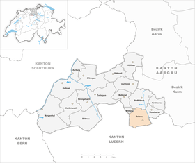
| Location of the municipality | |
  |
|
Reitnau ( Swiss German : ˈrɛitːˌnɔu ) is a municipality in the Swiss canton of Aargau . It belongs to the district of Zofingen , is located in the middle of the Suhrental and borders on the canton of Lucerne . Since a municipality merger on January 1, 2019, the municipality also includes the previously independent village of Attelwil .
geography
The community consists of four districts, the buildings of which have grown together loosely. On the western edge of the largely flat valley is the Unterdorf, Attelwil around one kilometer north of it. Oberdorf and Hubel are around 40 meters elevated on an elongated lateral moraine that was created during the Würme Ice Age when the Reuss Glacier retreated . The Suhre forms the eastern boundary of the municipality. The river was straightened in the mid-1920s and the extensive swamp in the plain drained. To the west of the moraine there are numerous hills; from north to south these are the Hornig ( 643 m above sea level ), the Tannholz ( 679 m above sea level ), the Bluemisweg ( 652 m above sea level ), the Stockrüti ( 673 m above sea level ), the Birch ( 672 m above sea level ) and the Lügisried ( 687 m above sea level ). These hills drop steeply into the Uerkental on the canton border.
The area of the municipality is 802 hectares , of which 283 hectares are forested and 99 hectares are built over. The highest point is at 687 meters on the Lügisried, the lowest at 472 meters on the Suhre. Neighboring communities are Wiliberg in the northwest, Staffelbach in the north, Moosleerau in the northeast, the Lucerne community Triengen in the south and east and Reiden in the west.
history

Various found objects point to a kind of dealer depot on the Birch during the Bronze Age . Reitinowa was first mentioned in a document in 1045. At that time, the Count von Lenzburg sold the village and the church to the Schänis monastery . The place name comes from the Old High German Reitinouwa and means "land of Reito close to the water". In the chronicle of Johannes Stumpf from the year 1548 it can be read that a noble family lived in Reitnau who moved to the Allgäu . The Counts of Kyburg followed the Lenzburger in 1173 . After these died out, the Habsburgs exercised sovereignty and blood justice from 1273 .
In 1415 the confederates conquered Aargau. Reitnau now belonged to the subject area of the city of Bern , the so-called Bern Aargau . The village formed its own judicial district in the Lenzburg district . Even after the Reformation of 1528, the Catholic Schänis monastery remained the owner of the church and appointed the reformed pastor until 1785. In March 1798 the French took Switzerland, ousted the «Gracious Lords» of Bern and proclaimed the Helvetic Republic . Since then Reitnau has belonged to the canton of Aargau. The church set changed from Schänis Monastery to private hands in 1807 and has belonged to the canton since 1850.
Around 1850 the village had well over 1000 inhabitants. However, economic hardship forced many Reitnauers to emigrate, mainly overseas. The population stagnated at around 850 for several decades, but has increased by over a quarter since the early 1990s due to increased construction activity. In a referendum on November 26, 2017, the incorporation of Attelwil was decided, the result was 340 yes to 65 no.
Attractions
From the first church, built in Romanesque style, some of the wall remains, which were uncovered in 1948. The new Reformed Church Reitnau in Gothic style was built in 1522, the neo-Romanesque church tower in 1900. The stained glass on the church windows also date from 1522 and refer to the donors of the new building (Schänis Abbey and the cities of Bern and Lucerne ). The rectory is a late Gothic building from 1616.
The Gutenberg Museum, opened in 2016 in the basement of the Altherr printing house, shows the centuries of changes in the art of book printing.
coat of arms
The blazon of the municipal coat of arms reads: "In blue on a green three-mountain red armed white heron." The community seals of 1811 and 1872 showed a rooster; However, this was replaced by a heron before 1915 , which symbolizes the once extensive swamp areas on the Suhre.
population
The population developed as follows (without Attelwil) :
| year | 1764 | 1850 | 1900 | 1930 | 1950 | 1960 | 1970 | 1980 | 1990 | 2000 | 2010 |
| Residents | 461 | 1082 | 812 | 849 | 915 | 850 | 854 | 884 | 904 | 1,143 | 1'219 |
On December 31, 2019, 1,553 people lived in Reitnau, the proportion of foreigners was 11.3%. In the 2015 census, 55.3% described themselves as Reformed and 19.2% as Roman Catholic ; 25.5% were non-denominational or of other faiths. 94.0% said German as their main language in the 2000 census and 1.4% Albanian .
Politics and law

The assembly of those entitled to vote, the municipal assembly , exercises legislative power. The executing authority is the five-member municipal council . He is elected by the people in the majority procedure, his term of office is four years. The parish council leads and represents the parish. To this end, it implements the resolutions of the municipal assembly and the tasks assigned to it by the canton. The District Court of Zofingen is primarily responsible for legal disputes . Reitnau is part of the XVI judges' circle (Zofingen).
economy
In Reitnau (including Attelwil) there are around 620 jobs according to the corporate structure statistics (STATENT) collected in 2015, 17% of them in agriculture, 42% in industry and 41% in the service sector. The industrial operations include a printing shop and a packaging machine factory. In the past raincoats and Bally shoes were also made. Most of the employed are commuters and work in the lower Suhrental or in the Aarau region .
The joint external warehouse for the Swiss nuclear power plants has existed in Reitnau since June 2011, and the ENSI supervisory authority requested it to be set up after the Fukushima nuclear disaster . Pumps, emergency power generators, hoses, fuel and other material are stored in it, which, if necessary , can be flown to the scene in Super Puma helicopters of the Swiss Air Force .
traffic
Reitnau is located on Kantonsstrasse 325 between Schöftland and Knutwil . The main road 24 between Aarau and Sursee runs one kilometer east of the village. The connection to public transport is provided by a post bus line from Schöftland via Reitnau to Sursee train station .
education
The community has a kindergarten and a school house where primary school is taught. The Realschule and the secondary school can be attended in Staffelbach , the district school in Schöftland . The closest grammar school is the Zofingen Cantonal School .
Motorsport
The Swiss Automobile Club has held the Reitnau hill climb since 1965 . This motorsport hill climb takes place at the end of June and attracts more than 12,000 spectators. Racing drivers compete in various categories on a steeply inclined and winding route that leads from the village center up to the Berghof.
Personalities
- Susanne Hochuli (* 1965), member of the government
literature
- Christian Lüthi: Reitnau. In: Historical Lexicon of Switzerland .
- Michael Stettler : The art monuments of the canton of Aargau . Ed .: Society for Swiss Art History . Volume I: The districts of Aarau, Kulm, Zofingen. Wiese Verlag, Basel 1948, DNB 366495623 .
Web links
Individual evidence
- ↑ Cantonal population statistics 2019. Department of Finance and Resources, Statistics Aargau, March 30, 2020, accessed on April 2, 2019 .
- ↑ Cantonal population statistics 2019. Department of Finance and Resources, Statistics Aargau, March 30, 2020, accessed on April 2, 2019 .
- ↑ a b Beat Zehnder: The community names of the canton of Aargau . In: Historical Society of the Canton of Aargau (Ed.): Argovia . tape 100 . Verlag Sauerländer, Aarau 1991, ISBN 3-7941-3122-3 , p. 344-345 .
- ^ National map of Switzerland, sheet 1109, Swisstopo.
- ↑ Standard area statistics - municipalities according to 4 main areas. Federal Statistical Office , November 26, 2018, accessed on May 27, 2019 .
- ↑ Two villages become one: Attelwil (wafer-thin) and Reitnau (clear) say yes to the merger. Aargauer Zeitung , November 26, 2017, accessed on November 27, 2017 .
- ^ Stettler: The art monuments of the Canton of Aargau, Volume I: The districts of Aarau, Kulm, Zofingen. Pp. 288-292.
- ^ Gutenberg Museum
- ^ Joseph Galliker, Marcel Giger: Municipal coat of arms of the Canton of Aargau . Lehrmittelverlag des Kantons Aargau, book 2004, ISBN 3-906738-07-8 , p. 248 .
- ↑ Population development in the municipalities of the Canton of Aargau since 1850. (Excel) In: Eidg. Volkszählung 2000. Statistics Aargau, 2001, archived from the original on October 8, 2018 ; accessed on May 27, 2019 .
- ↑ Resident population by religious affiliation, 2015. (Excel) In: Population and Households, Community Tables 2015. Statistics Aargau, accessed on May 27, 2019 .
- ↑ Swiss Federal Census 2000: Economic resident population by main language as well as by districts and municipalities. (Excel) Statistics Aargau, archived from the original on August 10, 2018 ; accessed on May 27, 2019 .
- ↑ circles of justice of the peace. Canton of Aargau, accessed on June 21, 2019 .
- ↑ Statistics of the corporate structure (STATENT). (Excel, 157 kB) Statistics Aargau, 2016, accessed on May 27, 2019 .
- ↑ External warehouse for emergencies is available. ENSI Federal Nuclear Safety Inspectorate, accessed on February 17, 2014 .
- ↑ External camp Reitnau is a teaching from Fukushima. ENSI Swiss Federal Nuclear Safety Inspectorate, accessed on February 17, 2014 (including video from the TV program Schweiz aktuell on the Reitnau camp (broadcast on June 6, 2011)).
- ↑ Reitnau hill climb
- ↑ Ann-Kathrin Amstutz: Track record and 12,000 spectators: The motorsport classic ran like a picture book. Aargauer Zeitung , July 2, 2018, accessed on May 27, 2019 .
Aarburg | Bottenwil | Brittnau | Kirchleerau | Kölliken | Moosleerau | Murgenthal | Oftringen | Reitnau | Rothrist | Safenwil | Staffelbach | Strengelbach | Uerkheim | Vordemwald | Wiliberg | Zofingen
Former municipality: Attelwil | Balzenwil | Mühlethal | Riken | Wittwil
Canton of Aargau | Districts of the Canton of Aargau | Municipalities in the Canton of Aargau