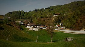
Mühlethal
| Mühlethal | ||
|---|---|---|
| State : |
|
|
| Canton : |
|
|
| District : | Zofingen | |
| Residential municipality : | Zofingen | |
| Postal code : | 4812 | |
| former BFS no. : | 4278 | |
| Coordinates : | 640 797 / 239082 | |
| Height : | 539 m above sea level M. | |
| Residents: | 800 (2001) | |
|
Proportion of foreigners : (residents without citizenship ) |
unknown | |
|
Mühlethal |
||
| map | ||
|
|
||
Mühlethal ( Swiss German : ˈmœʊɪ.tɑʊ ) is a village in the canton of Aargau in Switzerland . Until the end of December 2001 it was an independent political municipality in the Zofingen district before it was incorporated into the neighboring town of Zofingen . At the time of the merger, Mühlethal had around 800 inhabitants, the area of the municipality was 1.45 km².
geography
The village is located about two kilometers northeast of the city center of Zofingen in the rear part of the Mühletal (without h), a two-kilometer long eastern side valley of the Wigger . The narrow valley is bounded in the north by the Hochwacht ( 638 m above sea level ) and in the south by the foothills of the Munihubel. Mühlethal consists of three districts that have now grown together: The actual center is the "Dörfli" ( 539 m above sea level ), to the west of it is the new housing estate Öltrotte ( 520 m above sea level ). In the east, at the transition to the neighboring Uerkental , is Linden ( 583 m above sea level ); the border to the neighboring municipality of Uerkheim runs right through this district. In the north, the municipality of Mühlethal bordered on Safenwil , in the northwest on Oftringen and in the south on Zofingen.
history
Mulintal was first mentioned in a document in 1242. The place name comes from the Old High German (ze) mulintale and means "valley near the mill". The most important landowner was the Zofingen canon monastery . Until 1299 the village was under the rule of the Counts of Frohburg , then that of the Habsburgs . From 1415 Mühlethal was part of the subject area of the city of Bern , the so-called Berner Aargau . Again and again Mühlethal had to fight to be recognized as an independent community. It was not until 1756 that the authorities finally determined the border with Oftringen. In 1782, the Bernese authorities even considered the village to be part of Oftringen. Only a document sealed by the local council in 1804 confirmed that Mühlethal was now an independent municipality in the new canton of Aargau.
In 1812, when the forests of the former Aarburg office were divided among the various municipalities, Mühlethal seemed to have been forgotten or passed over, because the forest in the municipal area belonged entirely to the city of Zofingen or private individuals. Not least because of this, Mühlethal was a very poor community and in 1874 sought for the first time to join a neighboring community. Both Zofingen and Oftringen refused. Zofingen refused further requests in 1895 and 1897. In 1911, 1921 and 1937 three more requests for incorporation were made. Oftringen and Zofingen again rejected incorporation, but were at least willing to pay support. In addition, Zofingen was involved in building a new school building in the 1960s.
In 1970 it was Mühlethal that refused a merger, because the newly introduced financial equalization allowed taxes to be noticeably reduced. Within thirty years, the community's population doubled. However, the newly arrived residents were more oriented towards Zofingen, especially in economic terms. When the merger issue was back on the agenda in 1998, there was little resistance. In the referendum on June 13, 1999, the merger was clearly accepted in both communities, with 2,669: 316 votes in Zofingen and 333: 67 votes in Mühlethal. The merger finally took place on January 1, 2002.
population
The population developed as follows:
| year | 1764 | 1850 | 1900 | 1950 | 1980 | 2000 |
| Residents | 177 | 392 | 361 | 281 | 505 | 785 |
At the census in December 2000, almost a year before the merger, 785 people lived in Mühlethal. 56.3% described themselves as Reformed and 15.0% as Roman Catholic ; 28.7% were non-denominational or of other faiths. 95.2% said German as their main language and 1.7% Italian .
Attractions
literature
- Michael Stettler : The art monuments of the canton of Aargau . Ed .: Society for Swiss Art History . Volume I: The districts of Aarau, Kulm, Zofingen. Wiese Verlag, Basel 1948, DNB 366495623 .
Web links
- Christian Lüthi: Mühlethal. In: Historical Lexicon of Switzerland .
Individual evidence
- ↑ a b Beat Zehnder: The community names of the canton of Aargau . In: Historical Society of the Canton of Aargau (Ed.): Argovia . tape 100 . Verlag Sauerländer, Aarau 1991, ISBN 3-7941-3122-3 , p. 411-412 .
- ^ National map of Switzerland, sheet 1109, Swisstopo
- ↑ Information on the congregation merger ( Memento from March 4, 2016 in the Internet Archive )
- ↑ Population development in the municipalities of the Canton of Aargau since 1850. (Excel) In: Eidg. Volkszählung 2000. Statistics Aargau, 2001, archived from the original on October 8, 2018 ; accessed on May 28, 2019 .
- ↑ Swiss Federal Census 2000: Economic resident population by religious affiliation as well as by districts and municipalities. Statistical Office of the Canton of Aargau, archived from the original on November 5, 2012 ; Retrieved October 9, 2012 .
- ↑ Swiss Federal Census 2000: Economic resident population by main language as well as by districts and municipalities. (Excel) Statistics Aargau, archived from the original on August 10, 2018 ; accessed on May 28, 2019 .


