
Pfaffnau
| Pfaffnau | |
|---|---|
 |
|
| State : |
|
| Canton : |
|
| Constituency : | Willisau |
| BFS no. : | 1139 |
| Postal code : | 4915 (St. Urban) 6264 (Pfaffnau) |
| Coordinates : | 634 899 / 230 894 |
| Height : | 506 m above sea level M. |
| Height range : | 436–722 m above sea level M. |
| Area : | 17.68 km² |
| Residents: | 2678 (December 31, 2018) |
| Population density : | 151 inhabitants per km² |
|
Proportion of foreigners : (residents without citizenship ) |
13.3% (December 31, 2,015) |
| Website: | www.pfaffnau.ch |
 Parish church of St. Vinzenz, St. Antonius chapel and rectory with tithe barn |
|
| Location of the municipality | |
  |
|
Pfaffnau is a municipality in the Willisau constituency in the canton of Lucerne in Switzerland . The former St. Urban monastery with its enclosed garden is also in the municipality of Pfaffnau and is located 4.5 km west of the village of Pfaffnau.
geography
The community lies between the valley of the (Gondiswiler-) Rotbach and the Wiggertal in the north-west corner of the canton of Lucerne. The community consists of the districts Pfaffnau-Dorf and St. Urban ( 452 m above sea level ; 4.5 km west of Pfaffnau-Dorf), which is located directly at the point where the cantonal borders of Aargau , Bern and Lucerne meet. The two villages are defined by the two large forest areas cows forest and Tell forest separated. The place is in a hill area. The Pfaffneren flows through Pfaffnau-Dorf .
65.7% of the entire municipality is used for agriculture. Another 25.2% is forest area and 8.8% is settlement area.
Districts
In the east of the village are the Hüttenwald and the Bannwald . At (Gondiswiler) Rotbach and thus on the street Zell-St. Various hamlets are located in the urban area. The southernmost of these is Ludligen ( 527 m above sea level ; 4.1 km southwest of the village), in the east of which lies the large forest . Further north is the Berghof, which consists of two parts ( Unterberghof 496 m above sea level , Berghof 550 m above sea level ; 4.1 and 3.6 km west-southwest of the village, respectively), at whose eastern border the Baanwald begins. 1.5 km south of St. Urban is the hamlet of Grosse Sonnhalde ( 493 m above sea level ).
The district of St. Urban itself consists of several settlements. The southernmost is the Weiherhof , then to the north is the former St. Urban monastery . Neuschür is to the east of the monastery . In the north of the monastery there is a new building area and Murhof . The hamlet of Krummen ( 523 m above sea level ; 1.8 km northwest of the village) is located on the northern border of the municipality . Sagen is 600 m north of the village and has grown together with Hubel and is the third largest settlement in the municipality. In the northeast of the municipality are the hamlets Schulerslehn ( 526 m above sea level ; 1.9 km northeast) and Tannbach ( 560 m above sea level ; 1.8 km east-northeast). The hamlet of Käppeli is located between Tannbach and Pfaffnau-Dorf (1.2 km to the northeast). South of Tannbach is Nuttelen (1.2 km east of the village) and further south Burg (1.2 km southeast of the village) with the ruins of Pfaffnau Castle . To the east of Nuttelen and Burg lies the large Burgwald , which merges directly into the Langnauerwald in the north . Between Roggliswil and Richenthal lie the hamlets of Eberdingen (1.8 km southeast of the village; -119 m above sea level ) with the adjacent Eberdingerhöhe ( 712 m above sea level ) to the south and Uelihof ( 653 m above sea level ) even further south . ) and Witelingen ( 673 m above sea level ; 3 km south of Pfaffnau-Dorf).
Neighboring communities
The neighboring communities of Pfaffnau are in three different cantons. The Bernese neighboring towns are Melchnau , Roggwil and Langenthal , Brittnau and Murgenthal in Aargau and Altbüron , Grossdietwil , Reiden and Roggliswil in Lucerne .
population
| 1778 | 1860 | 1880 | 1900 | 1950 | 1970 | 1990 | 2006 |
|---|---|---|---|---|---|---|---|
| 1'215 | 1,907 | 1,771 | 1'954 | 2,523 | 2,584 | 2,601 | 2,106 |
The population increased sharply between 1798 and 1860 (1798-1860: +57.0%). This was followed by a decline in the resident population until 1870 and a sharp increase in the 1870s. Although the number of inhabitants fell by around a hundred between 1880 and 1900, the loss of population was small compared to other rural communities. This is also shown by a comparison (1850–1900: + 3.7%). The population grew moderately but steadily until 1950 (1900–1950: +29.1%), after which it stagnated for two decades. A minus between 1970 and 1980 was followed by a plus until 1990. Since then, the resident population has been falling again (1990–2004: −19.3%).
languages
The population uses a highly Alemannic dialect as their everyday language. At the last census in 2000, 94.02% gave German, 1.72% Serbo-Croatian and 0.96% Albanian as their main language.
Religions - denominations
In the past, all residents were members of the Roman Catholic Church . This has changed as a result of leaving the church and immigration from other regions in Switzerland and abroad. Today (as of 2000) the religious composition of the population is as follows: There are 70.75% Roman Catholic, 15.82% Evangelical Reformed and 3.89% Orthodox Christians. In addition, there are 3.64% non-denominational and 2.55% Muslim. The Orthodox are members of Slavic peoples (Serbs, Montenegrins and Macedonians) from the former Yugoslavia. The Muslims are almost without exception of Albanian origin.
Origin - nationality
At the end of 2014, of the 2,304 inhabitants, 2,045 were Swiss and 259 (= 11.2%) were foreigners. The population consisted of 88.8% Swiss citizens. The foreign residents came from Germany (37.1%), Serbia including Kosovo (18.1%), Portugal (13.9%), Italy (2.3%), Spain (1.2%) and Turkey ( 0.4%). 16.6% came from the rest of Europe and 10.4 % came from outside Europe.
history

The place was first mentioned under the name Fafanhaa in a deed of ownership from the Fraumünster Abbey in Zurich in 893. At the end of the 12th century, the Beromünster Canons and the Engelberg Monastery (OW) also owned goods in the community. The high level of jurisdiction is exercised by the Habsburgs who beat the community to the office of Willisau. The lower jurisdiction lies in the hands of the Lords of Pfaffnau and later of the St. Urban monastery . The year 1375 was an unlucky year for both Pfaffnau and the St. Urban monastery. The Gugler , the mercenary troops of Enguerrand VII. De Coucy , burned down both districts. After Habsburg lost the Battle of Sempach , the expanding city of Lucerne seized the area in 1407. Pfaffnau remained part of the Landvogtei Willisau until 1798 . Then the place was assigned to the Altishofen district until 1803 , before it was turned into the newly established Amt Willisau .
politics
Municipal council
The Pfaffnau municipal council consists of five members and is set up as follows:
- Thomas Grüter ( CVP ): Mayor
- Sandra Cellarius ( FDP ): Finance and Education / School
- Pirmin Bucheli (CVP): Social affairs
- Jörg Vonmoos (CVP): Construction
- Walter Eberhard ( IG UPS ): Environment / Security
Cantonal elections
In the 2015 Cantonal Council elections for the Canton of Lucerne, the share of the vote in Pfaffnau was: CVP 50.5%, SVP 26.1%, FDP 13.5%, SP 5.1%, GPS 3.4%, glp 1.5%.
National Council elections
In the 2015 Swiss parliamentary elections, the share of the vote in Pfaffnau was: CVP 32.9%, SVP 32.5%, FDP 14.2%, SP 6.9%, Greens 5.0%, glp 3.7%, BDP 2, 8th %.
traffic
The two districts of Pfaffnau and St. Urban can be reached by the Zofingen – Pfaffnau – St. Urban connected to the public transport network of the Limmat Bus company. St. Urban is also connected to the surrounding area by the Zell LU –Altbüron – St. Urban and the St. Urban– Langenthal railway line connected to the former Langenthal-Melchnau railway .
Pfaffnau and St. Urban are on the Reiden – Langenthal road. From Pfaffnau a road leads via Vordemwald AG to Zofingen AG, another to Altbüron. Various roads lead away from St. Urban - including to Zell LU and Langenthal. The next motorway junction in Reiden on the A2 motorway , from which you can reach Lucerne to the south-east after about 45 km, is 5 km from the village of Pfaffnau.
Attractions
Sons and daughters of the church
- Niklaus Purtschert (1750–1815), master builder and politician
- Guido Graf (* 1958), politician, Government Councilor of the Canton of Lucerne
- Christoph Graf (* 1961), officer in foreign services and 35th commander of the Pontifical Swiss Guard in the Vatican
- Eric Blum (* 1986), ice hockey player
- Nadja Purtschert (* 1989), snowboarder
photos
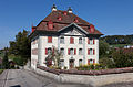
Pfaffnau, rectory with tithe barn (all of the following buildings are protected as cultural assets)

Pfaffnau, rectory and St. Antonius chapel
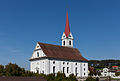
Pfaffnau, parish church of St. Vinzenz
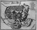
St. Urban , monastery complex 1654

St. Urban Monastery in the St. Urban district


.jpg)

Web links
- Official website of the Pfaffnau community
- Website of the district of St. Urban
- Community profile of the cantonal statistical office (PDF; 107 kB)
- Waltraud Hörsch: Pfaffnau. In: Historical Lexicon of Switzerland .
Individual evidence
- ↑ Permanent and non-permanent resident population by year, canton, district, municipality, population type and gender (permanent resident population). In: bfs. admin.ch . Federal Statistical Office (FSO), August 31, 2019, accessed on December 22, 2019 .
- ↑ Permanent resident population according to nationality category, gender and municipality ( memento of the original from January 1, 2015 in the Internet Archive ) Info: The archive link was inserted automatically and has not yet been checked. Please check the original and archive link according to the instructions and then remove this notice. (Permanent resident population)
- ↑ Balance of the permanent resident population according to demographic components, institutional structure, nationality and gender (Federal Statistical Office, STAT-TAB)
- ↑ LUSTAT: Pfaffnau community profile ( Memento of the original from May 8, 2016 in the Internet Archive ) Info: The archive link has been inserted automatically and has not yet been checked. Please check the original and archive link according to the instructions and then remove this notice.
- ↑ Municipal Council. Retrieved February 28, 2017 .
- ^ Stefan Calivers: Willisauer Bote. (PDF) Retrieved February 28, 2017 .
- ↑ LUSTAT: Pfaffnau community profile ( Memento of the original from May 8, 2016 in the Internet Archive ) Info: The archive link has been inserted automatically and has not yet been checked. Please check the original and archive link according to the instructions and then remove this notice.
- ↑ National Council elections 2015: strength of the parties and voter turnout by municipality. In: Results of the National Council elections 2015. Federal Statistical Office, 2016, accessed on June 3, 2016 .
Alberswil | Altbüron | Altishofen | Dagmersellen | Egolzwil | Ettiswil | Fischbach | Gettnau | Grossdietwil | Hergiswil near Willisau | Luther | Menznau | Nebikon | Pfaffnau | Reiden | Roggliswil | Schötz | Ufhusen | Wauwil | Wikon | Willisau | Cell
Former parishes: Buchs | Boar corners | Kottwil | Langnau near Reiden | Ohmstal | Richenthal | Uffikon | Willisau Land | Willisau city
Canton of Lucerne | Constituencies of the Canton of Lucerne | Municipalities of the Canton of Lucerne