
Wigger (river)
|
Wigger Änziwigger (upper course) |
||
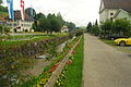
 The wiggers between Zofingen and Strengelbach |
||
| Data | ||
| Water code | CH : 507 | |
| location | Switzerland | |
| River system | Rhine | |
| Drain over | Aare → Rhine → North Sea | |
| source |
Well 47 ° 0 ′ 22 " N , 7 ° 56 ′ 40" E |
|
| Source height | approx. 1260 m above sea level M. | |
| muzzle | Between Rothrist and Aarburg near Wiggerspitz in the Aare Coordinates: 47 ° 18 ′ 56 ″ N , 7 ° 53 ′ 32 ″ E ; CH1903: 634 306 / 240620 47 ° 18 '56 " N , 7 ° 53' 32" O |
|
| Mouth height | 392 m above sea level M. | |
| Height difference | approx. 868 m | |
| Bottom slope | approx. 21 ‰ | |
| length | 41 km | |
| Catchment area | 380.29 km² | |
| Discharge at the gauge Zofingen A Eo : 366 km² Location: 4.5 km above the mouth |
NNQ (2003) MNQ 1980–2016 MQ 1980–2016 Mq 1980–2016 MHQ 1980–2016 HHQ (2007) |
800 l / s 3.45 m³ / s 5.77 m³ / s 15.8 l / (s km²) 7.87 m³ / s 168 m³ / s |
| Left tributaries | Luther | |
| Right tributaries | Buechwigger , Seewag , Wanger-Rot , Ron , Hürnbach | |

| ||
Source and mouth of the Wigger
|
The Wigger (formerly also Wiggeren , dialect Wiggere or Wegere ) is a 41 kilometer long river in the Swiss cantons of Lucerne and Aargau . It is an important tributary of the Aare and flows for almost its entire length in a south-north direction. The most important town in the Wiggertal is Zofingen .
course
The river, called Enziwigger in the uppermost part, rises on the northern slope of the Napf , not far from the border with the canton of Bern , at an altitude of around 1300 meters. It flows steeply down through a narrow valley to Hergiswil , where the valley becomes wider and much flatter. Shortly below the town of Willisau , it merges with the Buechwigger and is henceforth called Wigger. The valley widens to a flat and wide plain. To the north of Dagmersellen , the Wigger is largely canalised and partly runs parallel to the A2 motorway . The Aargau canton border is crossed between Reiden and Brittnau . Between Rothrist and Aarburg , the Wigger flows into the Aare at an altitude of 392 meters.
Tributaries of the Wigger are the Seewag , the Wanger-Rot , the Ron , the Luthern and the Hürnbach .
Usage and cultural history
The Wigger was subjected to a water correction in 1821 by the government of the Canton of Aargau . Up until the second half of the 19th century there were gold panning operations at the mouth of the Wigger , which were then given up due to a lack of income.
gallery
Enziwigger in Hergiswil near Willisau

Enziwigger in front of the historic town of Willisau

Estuary of the Wigger between Aarburg and Rothrist


Web links
- Waltraud Hörsch: Wigger (river). In: Historical Lexicon of Switzerland .
Individual evidence
- ↑ a b Geoserver of the Swiss Federal Administration ( information )
- ↑ Evaluations of the water network. (XLSX) FOEN , December 2013, accessed on August 9, 2017 (listing of Swiss rivers> 30km).
- ↑ Topographical catchment areas of Swiss waters: sub-catchment areas 2 km². Retrieved June 10, 2019 .
- ↑ Zofingen measuring station 1980–2016 (PDF) Federal Office for the Environment FOEN
- ^ A b Charles Knapp, Maurice Borel, Victor Attinger, Heinrich Brunner, Société neuchâteloise de geographie (editor): Geographical Lexicon of Switzerland . Volume 6: Tavetsch Val - Zybachsplatte, supplement - last additions - appendix . Verlag Gebrüder Attinger, Neuenburg 1910, p. 632, keyword Wigger, also Wiggeren . ( Scan the page )
Rivers with a total length of more than 30 km:
Aare |
Albula |
Allaine |
Old Rhine |
Arbogne |
Areuse |
Swiss stone pine |
Birs |
Brenno |
Broye |
Calancasca |
Doubs |
Drance de Bagnes |
Thinning |
Emme |
Engelberger Aa |
Ergolz |
Glâne |
Smooth |
Glenner (Glogn) |
Hinterrhein |
Inn (En) |
Julia (Gelgia) |
Kander |
Little Emme |
Landquart |
Land water |
Langete |
Limmat |
Linth |
Lorze |
Maggia |
Mentue |
Moësa |
Muota |
Murg |
Necker |
Orbe |
Petite Glâne |
Plessur |
Rabiusa |
Reuss |
Rhine |
Rhone |
Saane |
Schüss (Suze) |
Seez |
Scythe |
Sihl |
Simme |
Sitter |
Sorne |
Suhre |
Talent |
Tamina |
Ticino (Ticino) |
Thur |
Töss |
Venoge |
Verzasca |
Vispa |
Vorderrhein |
Wigger |
Wyna