Luthern (river)
|
Luthern Luthere |
||
|
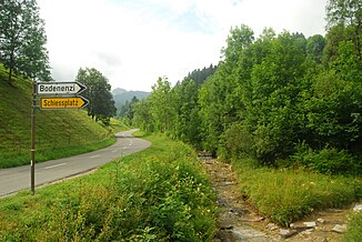
The Luthern between Luthern Dorf and Luthern Bad with the confluence of the Änzibach (from right) |
||
| Data | ||
| Water code | CH : 506 | |
| location |
Mittelland
|
|
| River system | Rhine | |
| Drain over | Wigger → Aare → Rhine → North Sea | |
| source | the bowl 47 ° 0 '24 " N , 7 ° 56' 28" O |
|
| Source height | approx. 1310 m above sea level M. | |
| muzzle | in the Wigger in Nebikon Coordinates: 47 ° 11 '28 " N , 7 ° 58' 27" E ; CH1903: 640 584 / 226815 47 ° 11 '28 " N , 7 ° 58' 27" O |
|
| Mouth height | 484 m above sea level M. | |
| Height difference | approx. 826 m | |
| Bottom slope | approx. 31 ‰ | |
| length | 26.9 km | |
| Catchment area | 104.68 km² | |
| Discharge at the Nebikon A Eo gauge : 105 km² Location: 110 m above the mouth |
NNQ (1998) MNQ 1988–2016 MQ 1988–2016 Mq 1988–2016 MHQ 1988–2016 HHQ (2002) |
190 l / s 920 l / s 1.5 m³ / s 14.3 l / (s km²) 2.09 m³ / s 75 m³ / s |
The Luthern ( Swiss German Luthere ) is an approximately 27 kilometers long left tributary of the Wigger in the Willisau office of the Canton of Lucerne and gives its name to the Luthern Valley ( Luthertal ).
course
The source of the Luthern lies north of the Napf . Especially after thunderstorms, the river is first a thundering mountain stream, which overcomes a height difference of 450 m over a distance of 2.5 km. Then it reaches - always flowing northwards - as the first larger settlement the district Luthern Bad (855 m high; 4 km south of the village of Luthern ). During the first 6 km it takes in several small and large streams from the side valleys. The most important, almost all of which flow from the left, are the Längenbach , Wilmisbach and Walenbach . Only the Spitzweidbach and the Wissenbach come from the right .
The rear Luthern Valley and the side valleys are heavily forested, in the higher elevations there are also some Alps. In the last few decades, the forest area has increased significantly, a development that began at the beginning of the 20th century when the government bought up many small farms in the back of the municipality and reforested the sometimes barren pastures. The clearing areas still predominate further north . Without changing its northern direction, the Luthern continues through the district of Hofstatt (2.5 km north of the village; 705 m), Rüediswil (3.3 km north; 696 m) to the Schachenfluh (683 m). Here is the deepest and at the same time northernmost point of the community of Luthern. In Hofstatt the Ellbach joins the Luthern from the left . The Ellbachtal (also called Flühlental) is a western side valley of the Luthern Valley. In this valley lies the hamlet of Flühlen (2.5 km northwest of Luhern Dorf; 772 m). North of the Ellbachtal, on the other side of the hill, there is a parallel valley. This is called Warmisbachtal and is completely forested in the upper reaches (Hegenwald). The Warmisbach forms the north-western boundary of the municipality.
The forest area, which covers 47.5% of the municipal area, and the agricultural area with 47.8% are the same size. In addition, 3.5% of the village is settlement area. The Luthern continues through Hüswil, Zell, Briseck, Gettnau and Niderwil to Schötz, where it was expanded in 2010. At Nebikon it finally flows into the Wigger .
Web links
- The Wigger and Luthern , Umwelt-luzern.ch
- Hydrological data from the Lutherans on the FOEN website
Individual evidence
- ↑ a b Geoserver of the Swiss Federal Administration ( information )
- ↑ Hydrological Atlas of Switzerland of the Federal Office for the Environment FOEN, Table_13
- ↑ Topographical catchment areas of Swiss waters: sub-catchment areas 2 km². Retrieved July 22, 2018 .
- ^ Luthern - Nebikon. (PDF) In: Federal Office for the Environment. Retrieved July 22, 2018 .
- ↑ pd / das: Expansion of the Luthern begins in November. Neue Luzerner Zeitung Online, October 28, 2010, accessed on December 29, 2010 .

