
Hergiswil near Willisau
| Hergiswil near Willisau | |
|---|---|
 |
|
| State : |
|
| Canton : |
|
| Constituency : | Willisau |
| BFS no. : | 1132 |
| Postal code : | 6133 |
| Coordinates : | 639 380 / 214 987 |
| Height : | 646 m above sea level M. |
| Height range : | 610-1382 m above sea level M. |
| Area : | 31.34 km² |
| Residents: | 1913 (December 31, 2018) |
| Population density : | 61 inhabitants per km² |
|
Proportion of foreigners : (residents without citizenship ) |
7.0% (December 31, 2,015) |
| Website: | www.hergiswil-lu.ch |
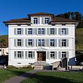
 View of Hergiswil with the village church Johannes d. baptist |
|
| Location of the municipality | |
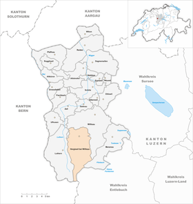  |
|
Hergiswil bei Willisau is a municipality in the Willisau constituency in the canton of Lucerne in Switzerland .
geography
The community is also known under the names Hergiswil am Napf and Hergiswil LU to distinguish it from Hergiswil NW, which is at the foot of the Pilatus . The extensive community consists of hills and mountains north of the Napf. The sprawl into a large number of individual farmsteads, groups of houses and hamlets is typical for this mountainous landscape, similar to that in Entlebuch .
The border to the municipality of Willisau goes from the Hengst (a mountain east of the Napf; 1372 m above sea level ) in the south along the Krachenbach to Wildhüsli ( 905 m above sea level ), then turns northeast to the Kanzelegg ( 1040 m above sea level) . M. ) and then follows the course of the Buchwigger to the hamlet of Rohrmatt ( 665 m above sea level ). This valley of the Buchwigger is called Kanzelgraben . The whole area on the left (western) bank belongs to the municipality of Hergiswil, the one on the right (eastern) bank to Willisau. However, the main valley of the community lies along the course of the Enziwigger . It rises near the Napf ( 1406 m above sea level ) and flows northwards down into the valley. Numerous streams from the small side valleys flow into it. The most important are the Ritterlochbach , the Weissenbach and the Dürstenbach from the right - and the Holzbach and the Fürbach from the left. The upper reaches of both streams are heavily forested; further down the clearing predominates. The main settlement is the village of Hergiswil ( 647 m above sea level ) , which consists of several parts . Other larger settlements are: the district of Hübeli (2.6 km south; 704 m above sea level ), Opfersei (east of Hübeli; 707 m above sea level ), Unterskapf (east of Opfersei; 861 m above sea level ) and St. Joder (5 km southeast of the village; 945 m above sea level ) in the so-called hinterland - and Mörisegg (1.4 km northeast of the village; 708 m above sea level ) as the largest hamlet in the so-called Unterland .
59.3% of the municipal area of 3,137 ha is used for agriculture; 36.7% (mainly in the hinterland) are covered with forest and wood and only 3.5% is settlement area.
population
| Population development | |
|---|---|
| year | Residents |
| 1816 | 2,021 |
| 1850 | 2,487 |
| 1900 | 1,940 |
| 1910 | 1,938 |
| 1930 | 2,138 |
| 1950 | 2,130 |
| 1980 | 1,708 |
| 1990 | 1,728 |
| 2000 | 1'809 |
| 2004 | 1,816 |
By 1850, the population grew rapidly due to a high birth surplus (1816–1850: + 23.1%). In the fifty years to 1900 it fell massively due to emigration to the industrial areas (1850–1900: –22.0%) - slowly until 1880, then faster. It stagnated in the first decade of the 20th century, then grew again until 1930 (1910–1930: + 10.3%). After a further stagnation phase of 20 years, another strong wave of emigration followed until 1980 (1950–1980: −19.2%). A slight growth began from 1990, which continues to this day (becoming weaker) (1980–2004: +5.1).
languages
The population uses a highly Alemannic dialect as their everyday language. In the last census in 2000, 97.95% said German, 0.83% Albanian and 0.33% Serbo-Croatian as their main language.
Religions - denominations
The entire population used to be members of the Roman Catholic Church. This has changed due to immigration from other regions and from abroad. Today (as of 2000) the religious landscape looks like this: There are 86.07% Roman Catholic, 7.52% Evangelical Reformed and 0.44% Free Church Christians. In addition, there are 1.66% non-denominational and 0.55% Muslim.
Origin - nationality
At the end of 2014, 1,761 of the 1,869 inhabitants were Swiss and 108 (= 5.8%) foreigners. The population consisted of 94.2% Swiss citizens. At the end of 2014, the foreign residents came from Germany (39.8%), Portugal (13.0%), Serbia including Kosovo (6.5%), Spain (4.6%), Turkey (3.7%) and Italy (0.9%). 17.6% came from the rest of Europe and 13.9 % came from outside Europe.
history

The place appears for the first time under the name Hergiswile in the oldest goods toboggan of the monastery Einsiedeln from the years 1217/1222. The supremacy changed from the Counts of Lenzburg to the Habsburgs . These set the barons of Hasenburg as local administrators. After their extinction, the Counts of A (a) rberg-Valangin took over the reign. With the consent of the Habsburgs, they sold the entire county of Willisau, to which Hergiswil belonged, to the city of Lucerne in 1407 . Until 1798 the place was part of the Landvogtei Willisau. After that he belonged to the Helvetian district of Willisau until 1803 - since then to the then newly created office of Willisau .
politics
Municipal council
The Hergiswil near Willisau municipal council consists of five members and is set up as follows:
- Urs Kiener ( FDP ): Mayor
- Pius Hodel ( CVP ): Mayor
- Anna Christen (CVP): Social Director
- Markus Kunz (CVP)
- Renate Ambühl ( SVP )
Cantonal elections
In the 2015 cantonal elections in the canton of Lucerne, the share of the vote in Hergiswil near Willisau was: CVP 53.9%, SVP 28.4%, FDP 14.2%, GPS 1.5%, SP 1.3%, glp 0.7% .
National Council elections
In the Swiss parliamentary elections in 2015, the share of the vote in Hergiswil near Willisau was: CVP 44.5%, SVP 37.1%, FDP 12.6%, SP 1.9%, Greens 1.8%, glp 1.3%, BDP 0.4%.
traffic
Most of the community is served by the Willisau-Hübeli post bus line. In Willisau there is a train station on the Wolhusen-Huttwil-Langenthal line. The community is off the main roads. The closest motorway connections are Dagmersellen 17 km and Sursee 18 km away. Both on the A2 .
Attractions

The parish church of St. John the Baptist is a monumental, classical work from 1840–1842. The exterior is matter-of-fact and strict. The designer is Josef Weibel from Lucerne.
In the village there are several houses, including the former schoolhouse and today's parish hall, which testify to the immigration of Italians around 1900. The construction manager was Luigi Macchi, who came from Varese , Italy . The Chapel of Our Lady is located about three kilometers from the village in the direction of Napf in the hamlet of Hübeli. It was built in 1951. The reason was the sparing of the Second World War and the long distance to the parish church. The designer was the pastor Adolf Bösch from Richenthal . A large part of the artistic equipment comes from Albert Wider from Widnau in Sankt Gallen .
photos
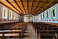
Interior view of the Hübeli way chapel
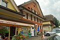
Bakery-Café Thalmann

Gasthaus Kreuz

Catholic parish church
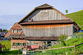
Farmhouse

Enziwigger

Parish Church of St. John the Baptist
Local government

school


literature
- Hergiswil near Willisau: the gold and herb village on the Napf . Hergiswil municipality near Willisau, 2017.
Web links
- Official website of the Hergiswil community
- Community profile of the cantonal statistical office (PDF; 111 kB)
- Waltraud Hörsch: Hergiswil near Willisau. In: Historical Lexicon of Switzerland .
Individual evidence
- ↑ Permanent and non-permanent resident population by year, canton, district, municipality, population type and gender (permanent resident population). In: bfs. admin.ch . Federal Statistical Office (FSO), August 31, 2019, accessed on December 22, 2019 .
- ↑ Permanent resident population by nationality category, gender and municipality ( memento from January 1, 2015 in the Internet Archive ) (permanent resident population)
- ↑ Balance of the permanent resident population according to demographic components, institutional structure, nationality and gender (Federal Statistical Office, STAT-TAB)
- ^ LUSTAT: Community profile Hergiswil b. Willisau ( Memento from May 8, 2016 in the Internet Archive )
- ^ LUSTAT: Community profile Hergiswil b. Willisau ( Memento from May 8, 2016 in the Internet Archive )
- ↑ National Council elections 2015: strength of the parties and voter turnout by municipality. In: Results of the National Council elections 2015. Federal Statistical Office, 2016, accessed on June 3, 2016 .
Alberswil | Altbüron | Altishofen | Dagmersellen | Egolzwil | Ettiswil | Fischbach | Gettnau | Grossdietwil | Hergiswil near Willisau | Luther | Menznau | Nebikon | Pfaffnau | Reiden | Roggliswil | Schötz | Ufhusen | Wauwil | Wikon | Willisau | Cell
Former parishes: Buchs | Boar corners | Kottwil | Langnau near Reiden | Ohmstal | Richenthal | Uffikon | Willisau Land | Willisau city
Canton of Lucerne | Constituencies of the Canton of Lucerne | Municipalities of the Canton of Lucerne