
Hergiswil NW
| NW is the abbreviation for the canton of Nidwalden in Switzerland and is used to avoid confusion with other entries of the name Hergiswil . |
| Hergiswil | |
|---|---|
 |
|
| State : |
|
| Canton : |
|
| District : | No district division |
| BFS no. : | 1507 |
| Postal code : | 6052 |
| Coordinates : | 666 481 / 204108 |
| Height : | 449 m above sea level M. |
| Height range : | 433–2129 m above sea level M. |
| Area : | 14.30 km² |
| Residents: | 5777 (December 31, 2018) |
| Population density : | 404 inhabitants per km² |
|
Proportion of foreigners : (residents without citizenship ) |
20.5% (December 31, 2,015) |
| Website: | www.hergiswil.ch |
 Hergiswil seen from the lake |
|
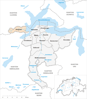
| Location of the municipality | |
  |
|
Hergiswil (also Hergiswil am See ) is a municipality in the Swiss canton of Nidwalden .
Surname
The place name is first documented in 1246 in the phrase Ruodolfus dictus de Hergoßwile, "Rudolf called von Hergiswil". It is a combination of the Old High German male personal name Harigaoz, Herigoz or the like with Old High German wĩlari "hamlet, farmstead" and thus means "court settlement of Harigaoz, Herigoz". The popular interpretation as "Herrgotts Weiler" is linguistically untenable.
geography
Hergiswil lies at the foot of Mount Pilatus on Lake Lucerne . The area of the municipality is 1699.6 hectares. Only 29.3% of the entire municipal area can be used for agriculture. Another 44.4% is covered by forest or wood. 9.7% of the municipal area is used as settlement area; another 16.6% are unproductive areas. The reason for the low proportion of agriculturally usable soil and settlement area is simple: the entire eastern slope of the Pilatus massif belongs to the municipality. This consists partly of rock and rubble. This also explains the high proportion of forest and wood. Both on the Lopper - a hill that separates Hergiswil and Alpnach - and on the slope of the Pilatus there are large areas of protective forest. So that there is no erosion and snow avalanches and rockfalls do not get down to the place.
history
The name Hergiswil (Hergenswile) was first mentioned in a Habsburg document around 1306. The land on which Hergiswil was built had belonged to the city of Lucerne since the 9th century and was bought by the von Moos family, more precisely Heinrich von Moos , at the beginning of the 14th century . In 1378, the inhabitants of the small fishing village of Hergiswil bought themselves free from the von Moos family with 700 guilders, and on November 17, 1378 they became an independent community ( Yrti ) of the canton of Nidwalden.


In 1798 and the following years there were repeated battles in Hergiswil between Unterwaldners and French and Helvetic troops. This led to tensions with the other municipalities of the canton because the Hergiswil residents surrendered to the French without a fight and shot at the French from Hergiswil from Stansstad. In contrast to the rest of the canton, the Hergiswil residents were more pro-federal. Hergiswil has been a liberal (free-thinking) stronghold since Switzerland was founded. This is in contrast to the other municipalities of Nidwalden, where the CVP dominated.
On January 1, 1906, the first telephone exchange was opened in Hergiswil. At that time the village had 11 telephone connections; today there are around 3800 connections.
population
Population development
The population grew strongly between 1769 and 1850. The high birth surplus and the founding of Glasi Hergiswil (newcomers) were the main reasons for this. Between 1850 and 1900 the population grew only slowly. In that fifty year period it increased by 276 people or 34.3%. The high population of 1888 is due to construction work on the Brünig Railway. This growth accelerated between 1900 and 1920, when tourism came into the community. From 1920 to 1970 the number of residents rose sharply (1920–1970: +199.5%). It had tripled in half a century. The low taxes and the proximity to the city of Lucerne (less than 10 km) contributed significantly to this. The number of newcomers meant that there were more and more people who felt closer to Lucerne than the Nidwalden communities 'ennet dem See'. Hergiswil is today the only Nidwalden municipality to be part of the Lucerne agglomeration. Due to the scarcity of building land and the influx of wealthy people, which led to the sharp rise in land prices, population growth was slowed from 1970 onwards. In the 1970s, the population even fell. As a result, the population only increased by 1.5% from 1970 to 1990. The community then zoned agricultural areas on the hillside into additional residential areas. At the same time, the construction method in the previous residential areas became more concentrated. Single-family houses were demolished and multi-family houses were built on the same site. Because of the high rents resulting from the low taxes, more and more young families moved away. The population was aging. The community responded and built social housing for families with children and the poor. This led again to the rejuvenation of the population and to a strong population growth from 1990 (1990–2013: + 25.9%).
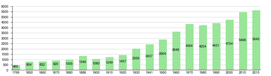
Population development of Hergiswil since 1769 Source: Population censuses (1850–2000 Federal), Federal Statistical Office (2010 and 2015)
languages
Almost the entire population speaks German as the everyday language. In the last census in 2000, 91.0% said German, 2.0% Italian and 1.1% French were their main languages.
The highest Alemannic Nidwalden German is spoken less and less. The many newcomers and, increasingly, the locals speak a high-Alemannic dialect stadtluzernischer embossed with a sprinkling of other dialects. Long-established Hergiswiler say as yet fRii and füüf for the words "free" and "five", the vast majority of immigrants while in the city of Lucerne Fräi and föif used.
Religions - denominations
The population used to be fully members of the Roman Catholic Church. The denominational relationships in 2000 still show the original structure, despite the mixture: 3252 people were Catholic (68.41%). There were also 16.13% Evangelical Reformed and 0.65% Orthodox Christians, 1.96% Muslims, 0.23% Jews and 7.91% non-denominational. 164 people (3.45%) did not provide any information on their creed. In Hergiswil there is next to the Catholic Church of St. Nikolaus and various chapels (Rengg and Fräkmünt) also a Reformed Church (consecrated in 1947).
Origin - nationality
At the end of 2017, 4,569 (79.95%) of the residents were Swiss nationals. The majority of the immigrants come from Central Europe (Germany 314, Austria 36, Netherlands 25, Great Britain and Hungary each 24, France 21 people), from Southern Europe (Italy 139, Portugal 103 and Spain 23 people), the former Yugoslavia (Kosovo 55, Bosnia and Herzegovina) Herzegovina 34, Serbia 17, Slovenia 13 and Croatia 11 people), Eritrea (30 people) and Sri Lanka (27 people). At the 2000 census, 4,199 people (88.33%) were Swiss citizens; of these, 242 people had dual citizenship.
age structure
The church has a high proportion of middle-aged people. While the proportion of people under the age of twenty makes up 14.84% of the local population, 29.29% are senior citizens (60 years and older). The largest age group is now between 45 and 59 years. In 2000 it was still in the 30 to 44 age group. The reason for this is the aging of the baby boomer generation (born up to 1965). For every 100 people of working age (20–64 years; 3585 people) there are 24 young people (848 people) and 36 people (1282 people) of retirement age.
The current age distribution is shown in the following table:
| Age | 0–6 years | 7-15 years | 16-19 years | 20-29 years | 30–44 years | 45–59 years | 60–79 years | 80 years and more | Residents | ||
| number | 288 | 386 | 174 | 639 | 1069 | 1485 | 1344 | 330 | 5715 | ||
| proportion of | 5.04% | 6.75% | 3.04% | 11.18% | 18.71% | 25.98% | 23.52% | 5.77% | 100% | ||
| Source: Federal Statistical Office, population by age at the end of 2017 | |||||||||||
The aging increases. A comparison with the year 2000 proves this. The last census in 2000 showed the following age structure:
| Age | 0–6 years | 7-15 years | 16-19 years | 20-29 years | 30–44 years | 45–59 years | 60–79 years | 80 years and more | Residents |
| number | 264 | 394 | 172 | 439 | 1263 | 1088 | 921 | 213 | 4754 |
| proportion of | 5.55% | 8.29% | 3.62% | 9.23% | 26.57% | 22.89% | 19.37% | 4.48% | 100% |
economy
In earlier times the main occupations were farmers (mostly cattle breeding) and fishermen. From the 17th century onwards, businesses such as brickworks and sawmills were added. This remained so until the 19th century. In addition to the glass factory mentioned below, road and rail construction, the construction industry and other small businesses were added. Bigger employers are the headquarters of the lift manufacturer Schindler as well as companies from the construction industry. At the same time a major tourist attraction is the Glasi Hergiswil , founded in 1817 , which produces handcrafted glass and exhibits the history of glass blowing in a museum.
In Hergiswil there were (2005) 2846 employees in 489 companies. 3.1% of employees in Hergiswil work in agriculture / forestry / fishing, 23.4% in industry and trade and 73.5% in service companies. The unemployment rate in 2007 was 1.24%.
The current figures for 2017 are as follows:
| Companies 1st sector |
Employees 1st sector |
Full-time positions 1st sector |
Companies 2nd sector |
Employees 2nd sector |
Full-time positions 2nd sector |
Companies 3rd sector |
Employees 3rd sector |
Full-time positions 3rd sector |
Operations total |
employees Total |
Total full-time positions |
|
| number | 22nd | 54 | 34 | 74 | 470 | 406 | 697 | 2283 | 1660 | 793 | 2807 | 2100 |
| proportion of | 2.77% | 1.92% | 1.62% | 9.33% | 16.74% | 19.33% | 87.89% | 81.33% | 79.04% | 100% | 100% | 100% |
| Source: Federal Statistical Office; Statistics of the company structure STATENT, workplaces and employees by municipality and economic sector | ||||||||||||
The 1st or primary sector comprises agriculture / forestry / fisheries; the 2nd or secondary sector includes industry and commerce; the 3rd or tertiary sector are service companies. Micro companies are companies with fewer than 10 employees, small companies have 10 to 49 employees, medium-sized companies have 50 to 249 employees and large companies have 250 or more employees. For data protection reasons, the number of companies has not been listed since 2016, which only includes a small number of companies in their area. All businesses in the 1st sector were micro-businesses. In the 2nd sector there were 65 micro-enterprises, in the 3rd sector 653 micro-enterprises, 39 small enterprises and 5 medium-sized enterprises.
In 2000 there were 2403 people in employment in Hergiswil. Of these, 941 (39.16%) were locals and 1462 were commuters. The commuters came from all over the region. The largest contingent was made up of people from the canton of Lucerne (over 40%); 39% came from Nidwalden communities; 14% from Obwalden. In the same year, 2,658 people from Hergiswil were employed. Thus 1717 people worked in other parishes. 533 people (= 31% of all commuters) commuted to the city of Lucerne, 215 people to Stans and 130 people to Kriens. A total of only 18.5% commuted to other Nidwalden communities. In contrast, 56% in the canton of Lucerne. 7% also worked in the canton of Zug, 5% in the canton of Obwalden (especially Sarnen and Alpnach) and 4% in the canton of Zurich.
traffic
Until the middle of the 19th century, large goods could only be reached by boat from Stansstad or Lucerne . Overland there were only mule tracks over the Lopper to Obwalden or towards Horw and Kriens. After Hergiswil was opened up for the first time in the years 1854–1858 through the construction of the Brünigstrasse, it was also possible to get to Hergiswil by land. This road leads from Lucerne through Hergiswil to Obwalden and from there over the Brünig Pass to the Canton of Bern . Since the construction of the Acheregg bridge across Lake Lucerne, there has also been a road connection to the other municipalities of the canton of Nidwalden.
With the construction of the Brünigbahn (1887–1889), Hergiswil was finally connected to the rail network. Since December 16, 1964, Hergiswil has also been connected to the rest of the canton by rail. At that time, the Stanstad-Hergiswil line of the Lucerne-Stans-Engelberg Railway was opened. Both lines are now part of the Zentralbahn, which was founded in 2005 .
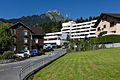
Today a road network of around 34.5 km runs through the village. It is connected to the A2 motorway , which has been running through the village since the 1970s and is clearly visible on a viaduct along the Lopper towards the south. In order to relieve the community of alternative traffic on the autobahn, a traffic control concept was developed. The first measures from the concept are to be implemented by April 2020. Two train stations , Hergiswil and the current bus station Hergiswil Matt, as well as a landing stage of the shipping company of Lake Lucerne, connect the village to the region's public transport .
schools
organization
With the ballot of May 15, 2011, it was decided to merge the independent bodies “Political Community” and “School Community”. Since May 23, 2012, the school has been part of the “Hergiswil Municipality” single community. The school commission, consisting of two municipal councils and three other members elected by the voters, is the strategic authority. The general school principal and the school principal are responsible for the operational implementation. The school secretariat and the property department head with his caretaker team support the school commission and school management. A mission statement sets out the most important principles and goals of the school.
Elementary level
Children from the age of 4 (due date June 30) can enter the basic level (GS). It combines the 1st and 2nd year of kindergarten and the 1st primary class. The basic level usually lasts three years, the classes are mixed in age. Then the children enter the 2nd grade of primary school.
Primary classes
The 2nd to 6th primary classes are in the Matt school building and the Dorf school building. Some of them are mixed in age. Classes, levels, school buildings and the entire primary school work closely together.
Lower secondary level (ORS)
The cooperative orientation school with the core classes A and B is run in the Grossmatt school building. Mathematics, English and French are taught at levels A and B; Optional offers for all classes supplement the compulsory lessons.
Culture
The multi-day Lake Side Festival has been held every year on the shores of Lake Lucerne in Hergiswil since 2001 . It started with 10 bands from central Switzerland on two weekends. In the meantime, bands from abroad can also be seen regularly and the festival is frequented by more than 5000 visitors. The hard rock band Fighter V from Hergiswil achieved greater awareness in 2019 with their debut album Fighter .
Attractions
- The Sigristenhaus from the late 15th century is one of the oldest surviving wooden houses in Central Switzerland.
- The neighboring church of St. Nicholas is a Byzantine style building from the years 1855–1857.
- The " Glasi ", a glassworks with a museum, glass labyrinth, water park, etc. a.
photos

Parish Church of St. Nicholas

reformed Church
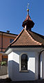
Chapel Maria for good advice

Sigristenhaus

Village square

Old village school house

Village schoolhouse

Grossmatt school building

Schoolhouse Matt

Loppersaal
Senior Center Zwyden

Parish hall
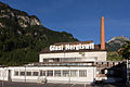
Glasi (glassworks)

Boat harbor

Section of the A2 in Hergiswil

Residential area Riedtmatt


Personalities
- Werner Sylten (1893–1942), Protestant theologian, victim of National Socialism
- Evelyne Binsack (* 1967), extreme mountaineer
- Michael Steiner (* 1969), Swiss filmmaker
- David Zibung (* 1984), goalkeeper of FC Luzern
- Reto Schmidiger (* 1992), slalom junior world champion 2010 and 2011
literature
- 600 years of Hergiswil 1378–1978. Published by the Hergiswil municipal council, 1978, commemorative publication on the occasion of the 600th anniversary
- Edwin Huwyler, Eduard Müller: The Hostattmätteli or Sigristenhaus in Hergiswil. (= Swiss Art Guide. Volume 562). Ed. Society for Swiss Art History GSK. Bern 1994, ISBN 3-85782-562-0 .
- Peter Steiner: Hergiswil (NW). In: Historical Lexicon of Switzerland .
Web links
Individual evidence
- ↑ Permanent and non-permanent resident population by year, canton, district, municipality, population type and gender (permanent resident population). In: bfs. admin.ch . Federal Statistical Office (FSO), August 31, 2019, accessed on December 22, 2019 .
- ↑ https://secure.i-web.ch/dweb/nw/de/onlinemain/publikationen/?pubid=8254&action=info ( page no longer available , search in web archives ) Info: The link was automatically marked as defective. Please check the link according to the instructions and then remove this notice.
- ↑ Lexicon of Swiss municipality names . Edited by the Center de Dialectologie at the University of Neuchâtel under the direction of Andres Kristol. Frauenfeld / Lausanne 2005, p. 439.
- ↑ See also Willy Elmer: Between the seas and heeche bears. A linguistic biography of the canton of Nidwalden: history - geography - everyday social life. Historischer Verein Nidwalden, Stans 2000, ISBN 3-906377-06-9 , where p. 38–41 and 52–55 specifically on Hergiswil.
- ↑ Nidwalden is fighting against traffic jams with dead ends and bans. In: luzernerzeitung.ch . January 30, 2020, accessed January 30, 2020 .
- ↑ History and festival posters 2001 to 2013 at lakesidefestival.ch, accessed on September 12, 2014.
- ↑ Eduard Huwyler, Eduard Müller: The Hostatt-Mätteli or Sigristenhaus in Hergiswil. (= Swiss art guide. No. 562). Ed. Society for Swiss Art History GSK. Bern 1994.
Beckenried | Buochs | Dallenwil | Emmetten | Ennetbürgen | Ennetmoos | Hergiswil | Oberdorf | Stans | Stansstad | Wolf shooting
Former municipality: Büren
Canton of Nidwalden | Districts | Municipalities in the canton of Nidwalden