
Stansstad
| Stansstad | |
|---|---|
 |
|
| State : |
|
| Canton : |
|
| District : | No district division |
| BFS no. : | 1510 |
| Postal code : |
6362 (Stansstad) 6363 (Fürigen) 6363 (Obbürgen) 6363 (Bürgenstock) 6365 (Kehrsiten) |
| Coordinates : | 668 494 / 203668 |
| Height : | 436 m above sea level M. |
| Height range : | 432-1004 m above sea level M. |
| Area : | 9.07 km² |
| Residents: | 4580 (December 31, 2018) |
| Population density : | 505 inhabitants per km² |
|
Proportion of foreigners : (residents without citizenship ) |
16.0% (December 31, 2,015) |
| Website: | www.stansstad.ch |
 Stansstad |
|
| Location of the municipality | |
  |
|
Stansstad is a municipality in the canton of Nidwalden in Switzerland .
geography


Stansstad is located on the narrow point of Lake Lucerne , which separates the Alpnachersee from the rest of the lake. The village itself is at the west foot of the Bürgenstock .
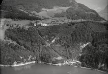
The districts of Obbürgen, Fürigen, Kehrsiten and part of the Rotzlochs also belong to Stansstad. Kehrsiten is located on the southern shore of Lake Lucerne 3 km east of Stansstad. Obbürgen is located on a plateau of the Bürgenstock immediately east of the village. Fürigen is located on a high plateau east of the village on the northern flank of the Bürgenstock. All of these three districts border on Bürgenstock, which, however, belongs to the city of Lucerne. The Bürgenstock Resort is located in the municipality of Stansstad. Rotzloch is located on the Alpnachersee.
33.8% of the entire municipal area can be used for agriculture. Almost half (49.9%) are covered by forest or wood. 14.9% of the municipal area is used as settlement area, another 1.4% is unproductive area. The plain between Lake Lucerne and Stans as well as parts of the Bürgenstock are used for agriculture, although most of it is forested.
population
Population development
The population stagnated between 1850 and 1880. In the period from 1850 to 1900 it only increased by 73 people or 9.4%. In the first half of the 20th century, apart from the time of the First World War, the population grew steadily, but only slowly (1900–1950: +54.9%). This changed with the improvement of the traffic situation ( Acheregg bridge , rail link to Hergiswil – Lucerne and the A2 motorway ). Stansstad also massively lowered the tax rate and became a 'tax haven' like the neighboring municipality of Hergiswil . This led to strong population growth from 1950 to 1990 (1950–1990: +187%). In 2000 the population was five times that of 100 years earlier. From 1990 onwards the growth slowed somewhat; the resident population has stagnated since 2010.

Population development in Stansstad since 1850 Source: Population censuses (1850–2000 Federal), Federal Statistical Office (since 2010)
languages
The population speaks a highly Alemannic dialect. Nidwalden German is spoken less and less. Due to the adaptation of the locals and due to the large number of newcomers, the majority speaks a mixed dialect of Lucerne German with sprinkles of other dialects. Almost the entire population speaks German as the everyday language. In the last census in 2000, 90.1% said German, 2.1% Italian and 1.5% Albanian were the main language.
Religions - denominations
The population used to be fully members of the Roman Catholic Church. The denominational relationships in 2000 still show the original structure despite the mixture. 2969 people were Catholic (68.65%). There were also 15.42% Evangelical Reformed and 0.95% Orthodox Christians, 2.80% Muslims and 9.16% non-denominational. 108 people (2.50%) did not provide any information on their creed. In Stansstad there are two other Catholic churches in Obbürgen and Kehrsiten in addition to the Catholic Church of St. Anna in the village (consecrated in 1943). There is also an ecumenical parish hall. The Reformed usually (apart from ecumenical occasions in the parish hall) visit the Reformed church in Stans.
Origin - nationality
At the end of 2015, 3,703 (84.24%) of the residents were Swiss nationals. The majority of the immigrants come from Central Europe (Germany and Austria), Southern Europe (Italy and Portugal) and the former Yugoslavia (Serbia, Montenegro, Kosovo and Bosnia-Herzegovina). At the 2000 census, 3768 people (87.12%) were Swiss citizens; 211 of them had dual citizenship.
age structure
The average age in the community has risen sharply in recent years. The proportion of people under the age of twenty was 19.56% in 2000 and only 14.40% of the local population in 2015. At the same time, the proportion of senior citizens (60 years and older) rose from 18.77% (2000) to 30.96% (2015). In 2000, the largest age group was made up of people between 30 and 44 years of age, now it is the age group between 60 and 79 years of age.
The following age structure emerged at the end of 2015:
| Age | 0–6 years | 7-15 years | 16-19 years | 20-29 years | 30–44 years | 45–59 years | 60–79 years | 80 years and more |
| number | 222 | 258 | 153 | 465 | 837 | 1100 | 1127 | 234 |
| proportion of | 5.05% | 5.87% | 3.48% | 10.58% | 19.04% | 25.02% | 25.64% | 5.32% |
Source: Federal Statistical Office, STATPOP
economy
In earlier times the main occupations were farmers (mostly cattle breeding), cheese makers, boatmen, timber traders and fishermen. This remained so until the 19th century. The rotating Acheregg Bridge from 1860 caused the proportion of boatmen to decline sharply. Today, in addition to small service companies, a detergent factory, a gravel and concrete factory, a hard stone factory, the construction industry, sawmills, wood, metal and boat building, the electronics industry, the Zentralbahn and the logistics company Intergate offer jobs.
In Stansstad there were (2005) 2245 employees in 320 companies. 3.6% of the employees in Stansstad work in agriculture / forestry / fishing (sector 1), 16.7% in industry and trade (sector 2) and 79.9% in service companies (sector 3). The unemployment rate in 2007 was 1.49%.
In 2017, 1241 of the 2,119 employees were male and 878 female. The numbers for the 3 sectors are as follows:
| Companies 1st sector |
Employees 1st sector |
Full-time positions 1st sector |
Companies 2nd sector |
Employees 2nd sector |
Full-time positions 2nd sector |
Companies 3rd sector |
Employees 3rd sector |
Full-time positions 3rd sector |
Operations total |
employees Total |
Total full-time positions |
|
| number | 24 | 57 | 41 | 56 | 421 | 361 | 338 | 1641 | 1256 | 418 | 2119 | 1658 |
| proportion of | 5.74% | 2.69% | 2.47% | 13.40% | 19.87% | 21.77% | 80.86% | 77.44% | 75.75% | 100% | 100% | 100% |
| Source: Federal Statistical Office; Statistics of the company structure STATENT, workplaces and employees by municipality and economic sector | ||||||||||||
In 2000 there were 1,486 people in employment in Stansstad. Of these, 696 (46.84%) were locals and 790 were commuters. Half of the commuters came from the closer region. The largest contingent was made up of people from the other Nidwalden communities (63%); 16% came from the canton of Lucerne and 10% from Obwalden. In the same year 2577 people from Stansstad were employed. Thus 1881 people worked in other parishes. 449 people commuted to the city of Lucerne (= 23.9% of all commuters), 385 people to Stans (20.5%), and 145 people (7.7%) to Hergiswil. A total of 36.7% commuted to other Nidwalden communities. In contrast, 42.5% in the canton of Lucerne. In addition, 6% worked in the canton of Zug and 5% in the canton of Obwalden (mainly Sarnen and Alpnach).
traffic
Until the middle of the 19th century, the village was mainly approached by boats from Hergiswil or Lucerne for large goods . Overland there was the all-way between Ennetmoos and Kerns. After Stansstad was opened for the first time in the 1860s with the construction of the rotating Acheregg Bridge, there was a connection to Brünigstrasse and therefore to Alpnach and the city of Lucerne. The first rail connection within the Engelberg Valley was the Stansstad – Stans tram , which opened in 1893. In 1898 the electrified Stansstad – Engelberg – Bahn was opened. The wish for a connection to Lucerne was fulfilled in 1964, and from then on the StEB railway company was called Lucerne-Stans-Engelberg-Bahn . Since the construction of the new Acheregg bridge and the construction of the A2 motorway , Stansstad has been extremely well developed in terms of transport. In order to relieve the community of alternative traffic on the autobahn, a traffic control concept was developed. The first measures from the concept are to be implemented by April 2020.
Attractions
- A former fortress of the Swiss Army from 1942 can be visited on Kehrsitenstrasse in the Fürigen district .
- Carving tower
photos
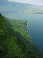
View from the Bürgenstock to Kehrsiten on Lake Lucerne
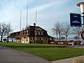
Ship landing with the former train station (until 1964)
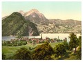
Stansstad around 1891


literature
- Stefan Länzlinger, Martin Lengwiler : The Fürigen fortress . GSK, Bern 2001, ISBN 3-85782-689-4 (= Swiss Art Guide GSK , Volume 689).
- Christoph Berger: The little book from the Stanserhorn . Odermatt, Dallenwil 2005, ISBN 3-907164-12-1 .
- Romano Cuonz , Hanspeter Niederberger : hotel king, manufacturer: Franz Josef Bucher - mountain railway builder, inventor: Josef Durrer - painter, dreamer: Beda Durrer. Brunner, Kriens 1998, ISBN 3-905198-45-2 .
Web links
- Official website of the municipality of Stansstad
- Christoph Baumgartner: Stansstad. In: Historical Lexicon of Switzerland .
Individual evidence
- ↑ Permanent and non-permanent resident population by year, canton, district, municipality, population type and gender (permanent resident population). In: bfs. admin.ch . Federal Statistical Office (FSO), August 31, 2019, accessed on December 22, 2019 .
- ↑ https://secure.i-web.ch/dweb/nw/de/onlinemain/publikationen/?pubid=8254&action=info ( page no longer available , search in web archives ) Info: The link was automatically marked as defective. Please check the link according to the instructions and then remove this notice.
- ↑ Nidwalden is fighting against traffic jams with dead ends and bans. In: luzernerzeitung.ch . January 30, 2020, accessed January 30, 2020 .
Beckenried | Buochs | Dallenwil | Emmetten | Ennetbürgen | Ennetmoos | Hergiswil | Oberdorf | Stans | Stansstad | Wolf shooting
Former municipality: Büren
Canton of Nidwalden | Districts | Municipalities in the canton of Nidwalden