
Wolf shooting
| Wolf shooting | |
|---|---|
 |
|
| State : |
|
| Canton : |
|
| District : | No district division |
| BFS no. : | 1511 |
| Postal code : |
6386 (Wolfenschiessen) 6387 (Oberrickenbach) |
| Coordinates : | 673 028 / 195 846 |
| Height : | 510 m above sea level M. |
| Height range : | 486–2896 m above sea level M. |
| Area : | 92.70 km² |
| Residents: | 2097 (December 31, 2018) |
| Population density : | 23 inhabitants per km² |
|
Proportion of foreigners : (residents without citizenship ) |
10.7% (December 31, 2,015) |
| Website: | www.wolfenschiessen.ch |
| Location of the municipality | |
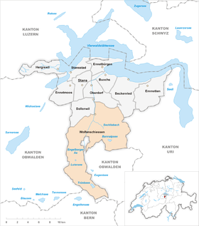  |
|


Wolfenschiessen (in the highest Alemannic local dialect Woufe (r) schiässä [ʋɔu̯fə (r) ʃiæsːæ] ) is a municipality in the Swiss canton of Nidwalden .
geography
The village of Wolfenschiessen is located in the lower Engelbergertal between Stans and Engelberg , at 510 m above sea level. M. The community area is 92.76 km², the boundary length 45.8 km.
The Oberrickenbach chapel community ( 894 m above sea level ), which also belongs to the Wolfenschiessen community , is located in a high eastern side valley, 400 meters above the Engelberg Valley and a good 4 km from the village center . The hamlet of Altzellen ( 658 m above sea level ) between Wolfenschiessen and Grafenort also belongs to the community . Numerous alpine areas such as Arni, Bannalp , Ober and Unter Trüebsee and Sinsgäu (am Brisen ) also belong to the largest municipality in terms of area in the canton of Nidwalden. The highest point in Wolfenschiessen is the Rotstöckli on the Titlis ( 2901 m above sea level ). The Jochpass, located in the Wolfenschiesser area, leads to the Bernese Oberland. To the east of the Engelberg Valley, the 1,341-meter-high Wellenberg rises between the inhabited parts of the community . It was viewed by NAGRA as a possible storage facility for radioactive waste.
Only 1.2% of the entire municipal area is settlement area. A large part of the community area is covered by wood and forest with a 33.0% share. An even larger area of 40.8% is used for agriculture - often as the Alps. And a full 24.9% are unproductive areas (mostly mountains and lakes).
history
The lower Engelbergertal was already settled by the Celts , Romans and from the 6th century by the Alemanni .
Wolfenschiessen is first attested in writing in a document from the 11th century (copy from the 14th century). The basic word probably goes back to Old High German scioʒ «Giebelseite»; In the fore link is probably the Old High German male personal name Wolfo . Wolfenschiessen means “at the farm, near Wolfo's houses” or, if shooting in Middle High German is seen in a figurative sense, in “Wolfo's corner of the terrain”. The municipal coat of arms is a talking coat of arms in that it interprets the place name according to folk etymology and shows a wolf that is pierced by an arrow.
The discussion about a repository for radioactive waste in Wellenberg has caused heated controversy in the Wolfenschiessen community and throughout Nidwalden over the past 25 years. Sometimes they split entire families. Despite multiple no's from the Nidwalden population to the Landsgemeinde and urn, NAGRA is still sticking to the (potential) location of Wellenberg.
population
Population development
Because of the limited number of jobs, the community experienced several large waves of emigration (1850–1860, 1880–1888 and 1960–1970). However, there was also a strong growth phase between 1888 and the beginning of World War I (1888–1910: +27.3%). Three further waves of growth (1930–1941, 1950–1960 and 1970–2000) ensured that the population is now much higher than it was in 1850. After a period of stagnation between 2000 and 2010, the population is growing again (2010-2013: +4.8 %). The reason for the increase was the improvement in public transport and, above all, the construction of the A2 . The community also became attractive for commuters due to its proximity to the Nidwalden capital, Stans, and the low building land prices.
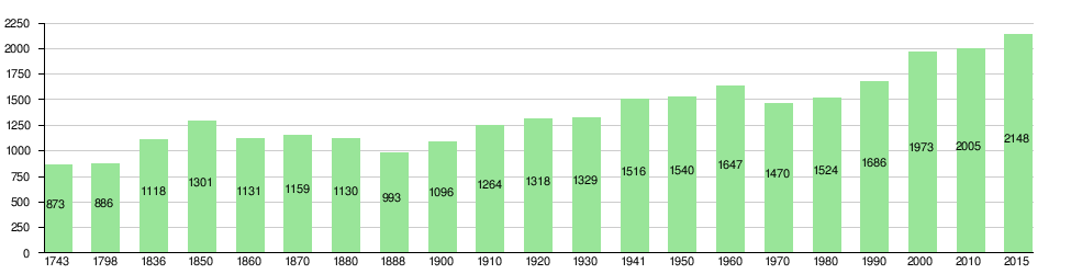
Population development in Wolfenschiessen since 1743 Source: Population censuses (1850–2000 Federal), Federal Statistical Office (2010 and 2015)
languages
The population speaks a highly Alemannic dialect, Nidwalden German. In the last census in 2000, 93.6% said German, 2.7% Albanian and 1.4% Serbo-Croatian as their main language.
Denominations
In 2000, 1,634 people were Catholic (82.82%). There were also 5.37% Protestant and 1.06% Orthodox Christians, 4.36% Muslims and 2.99% non-denominational. 63 people (3.19%) did not provide any information about their creed. Until about the 1970s, almost the entire population was Catholic. The secession of the church and immigration from other parishes and abroad has led to an increase in other confessional groups in Wolfenschiessen.
Origin - nationality
Of the 2,097 residents, 1,892 (90.22%) were Swiss nationals at the end of 2018. The majority of the immigrants come from Central Europe (Germany 42, Austria and Poland each 7, Netherlands 5 people), Southern Europe (Portugal 43 and Italy 14 people), the former Yugoslavia (Kosovo 37, Serbia 12 and Bosnia-Herzegovina 5 people) and Sri Lanka (7 people). At the 2000 census, 1,773 people (89.86%) were Swiss citizens; 45 of them had dual citizenship.
age structure
The church had a high percentage of younger people in 2000. While the proportion of people under the age of twenty made up 30.41% of the local population, 14.55% were senior citizens (60 years and older). The largest age group was made up of people between 30 and 44 years of age.
The last census in 2000 showed the following age structure:
| Age | 0–6 years | 7-15 years | 16-19 years | 20-29 years | 30–44 years | 45–59 years | 60–79 years | 80 years and more |
| number | 191 | 301 | 108 | 262 | 481 | 343 | 244 | 43 |
| proportion of | 9.68% | 15.26% | 5.47% | 13.28% | 24.38% | 17.38% | 12.37% | 2.18% |
The church today has a high proportion of younger and middle-aged people. While the proportion of people under the age of twenty makes up 23.94% of the local population, 23.22% are senior citizens (60 years and older). The largest age group is now between 45 and 59 years. The reason for this is the aging of the baby boomer generation (born up to 1965). For every 100 people of working age (20–64 years; 1230 people) there are 41 young people (502 people) and 30 people (365 people) of retirement age. The current age distribution is shown in the following table:
| Age | 0–6 years | 7-15 years | 16-19 years | 20-29 years | 30–44 years | 45–59 years | 60–79 years | 80 years and more | Residents | ||
| number | 155 | 245 | 102 | 251 | 396 | 461 | 397 | 90 | 2097 | ||
| proportion of | 7.39% | 11.68% | 4.86% | 11.97% | 18.88% | 21.98% | 18.93% | 4.29% | 100% | ||
| Source: Federal Statistical Office, population by age at the end of 2018 | |||||||||||
politics
coat of arms
Blazon : "In blue a soaring silver wolf , pierced from behind by a left-slanted golden arrow." - Thus it represents the place name as a talking coat of arms .
economy
Agriculture originally dominated in Wolfenschiessen. For the place important economic sectors are forestry and agriculture, the latter mainly in the form of dairy farming. Then there is tourism. Some craft and small businesses are also represented. In Oberrickenbach there is a hydropower plant that is operated with the water from the Bannalpsee , a good 500 m higher .
In Wolfenschiessen there were (2005) 634 employees in 181 companies. 36.0% of the employees in Wolfenschiessen worked in agriculture / forestry / fishing (sector 1), 21.8% in industry and trade (sector 2) and 42.3% in service companies (sector 3). The unemployment rate in 2007 was 0.88%.
The current figures for 2017 are as follows:
| Companies 1st sector |
Employees 1st sector |
Full-time positions 1st sector |
Companies 2nd sector |
Employees 2nd sector |
Full-time positions 2nd sector |
Companies 3rd sector |
Employees 3rd sector |
Full-time positions 3rd sector |
Operations total |
employees Total |
Total full-time positions |
|
| number | 81 | 204 | 115 | 28 | 180 | 155 | 103 | 507 | 353 | 212 | 891 | 623 |
| proportion of | 38.21% | 22.90% | 18.46% | 13.21% | 20.20% | 24.88% | 48.58% | 56.90% | 56.66% | 100% | 100% | 100% |
| Source: Federal Statistical Office; Statistics of the company structure STATENT, workplaces and employees by municipality and economic sector | ||||||||||||
In 2000 there were 535 employees in Wolfenschiessen. Of these, 385 (71.96%) were locals and 150 were commuters. Most of the commuters came from the region; namely from Dallenwil and Oberdorf (13.3% each), Beckenried (9.3%), Ennetbürgen (8.7%), Stans and Engelberg (8.0% each), Buochs (7.3%) and Stansstad ( 6.7%). In the same year 1,046 people from Wolfenschiessen were gainfully employed. Thus 661 people worked in other communities. 200 people (= 30.3% of all commuters) commuted to the main town of Nidwalden, Stans, 80 people (12.1%) to Engelberg, 47 people (7.1%) to the city of Lucerne, 43 people (6.5%) to Oberdorf %), according to Dallenwil 38 people (5.7%) and according to Buochs 31 people (4.7%). A total of 408 people (61.7%) commuted to other Nidwalden communities, 105 people (15.9%) to the canton of Obwalden and 80 people (12.1%) to the canton of Lucerne.
traffic
The Stans-Süd junction of the Gotthard motorway is only 6 km away. Wolfenschiessen is connected to the Luzern – Stans – Engelberg line of the Zentralbahn . Since the end of 2013, the S4 has also been leading from Lucerne to here. From the valley town of Wolfenschiessen, 4 small aerial cable cars lead to the surrounding Alps and mountain forests, which are used by locals, hikers and some paragliders . From the small mountain village of Oberrickenbach, no fewer than four cable cars, some of which seem quite adventurous, lead to Bannalp and Haldigrat .
tourism
Above all, the Oberrickenbach district and the Bannalp with its lake above are the starting point for alpine walks and hikes, for example over the Haldigrat to Niederrickenbach with its Benedictine monastery, or below the Walenstocks to Engelberg , or over the Schonegg pass towards Lake Uri .
From the Oberrickenbacher cable cars, the small 8-person cabin up to the Bannalpsee with its free slack in front of the vertical rock face is a particularly rewarding ride. On the Bannalp there is a small ski area at a height of 1700 m .
Attractions
In the center of the village is the large, late Baroque parish church built in 1775 .
Personalities
- Konrad Scheuber (1481–1559), Landammann, judge and hermit
- Jakob Joseph Matthys (1802–1866), priest, linguist and dialectologist
- Josef Scheuber (1881–1961), Rector of the Cantonal School Kollegium Schwyz and Regens of the Chur Seminary (today: Chur Theological University )
- Erika Hess (* 1962), ski racer
photos

Church in Wolfenschiessen

Hechhuis (Melchior Lussy)

Chapel of St. Sebastian

Station after conversion to the S-Bahn terminus with a view of the Rotsandnollen
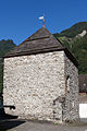
Tower in the Dörfli

Cable car to the Bannalpsee

On the way to Bannalp: View of Oberrickenbach

On the Bannalp: view of the Walenstock


Web links
- Official website of the community of Wolfenschiessen
- Information from the canton of Nidwalden about the municipality
- Hansjakob Achermann: Wolfenschiessen. In: Historical Lexicon of Switzerland .
Individual evidence
- ↑ Permanent and non-permanent resident population by year, canton, district, municipality, population type and gender (permanent resident population). In: bfs. admin.ch . Federal Statistical Office (FSO), August 31, 2019, accessed on December 22, 2019 .
- ↑ https://secure.i-web.ch/dweb/nw/de/onlinemain/publikationen/?pubid=8254&action=info ( page no longer available , search in web archives ) Info: The link was automatically marked as defective. Please check the link according to the instructions and then remove this notice.
- ↑ Albert Hug, Viktor Weibel: Nidwalden place and field names. Lexicon, index, commentary in 5 volumes. Edited by the historical association Nidwalden. Stans 2003, Vol. 4, Col. 1826-1832; Lexicon of Swiss municipality names . Edited by the Center de Dialectologie at the University of Neuchâtel under the direction of Andres Kristol. Frauenfeld / Lausanne 2005, p. 976.
- ↑ Old High German Glossary Dictionary, including the glossary index started by Taylor Starck. Compiled, edit. and ed. by John C. Wells. Heidelberg 1990.
- ^ Karl Keel: Nidwalden place and field names. Dissertation University of Freiburg. o. O. 1972.
- ↑ Albert Hug, Viktor Weibel: Nidwalden place and field names. Lexicon, index, commentary in 5 volumes. Edited by the historical association Nidwalden. Stans 2003, Vol. 4, Col. 1832. - Hug / Weibel name a - not attested - Old High German scioʒa as an exit, which they put in terms of vocabulary to Old High German scōʒ "Schoss, Bucht". This information is erroneously shortened in the lexicon of Swiss community names to the effect that scioʒa itself means "lap, bay", which is neither said by Hug / Weibel nor supported by any other source.
- ↑ fahrplanfelder.ch: PDF , accessed on October 21, 2010
- ↑ See route network of December 15, 2013
Beckenried | Buochs | Dallenwil | Emmetten | Ennetbürgen | Ennetmoos | Hergiswil | Oberdorf | Stans | Stansstad | Wolf shooting
Former municipality: Büren
Canton of Nidwalden | Districts | Municipalities in the canton of Nidwalden